
Copyright© 2004
North Fork Books, Publisher
201 Mine St. Leavenworth, WA 98826
northfork@nwi.net
Library of Congress Cataloging-in-Publications Data: Marler
East of the divide: travels through the eastern slope of the north cascades 1870-1999 by Chester Marler
ISBN: 0-9754605-051495
Cover and book design: Mark MacKay
Maps and preliminary design: Dan O’Connor/Glacier Graphics
Cover photo: Mt. Stuart, Enchantment Lakes–Wenatcehee World
Back Cover: Mt. Stuart, Iscrael C. Russel, 1897
Back cover inset: Enchantment Lakes, ski touring–Chester Marler
A note on the text : This book was set using Mrs. Eaves designed by Zuzan Licko for Emigre. It is a revival of a typeface designed by John Baskerville and named after his wife Sarah Eaves.
Acknowledgements
Foreword
Introduction
Prologue
Chapter One From High Pass to Ice Creek Ridge–Contrasting Landscapes
Chapter Two The Chiwaukum Mountains–Sylvester’s Range of High Lakes and Mountain Meadows
Chapter Three The Stuart Range–Granite Crags and Alpine Lakes
Chapter Four Ancient Ice
Chapter Five The Chelan and Sawtooth Ranges and North to the Pasayten Country
Chapter Six A Journey in 1870–A Grand Circle Through the Cascades
Chapter Seven Glacier Peak and Ice Creek Ridge–1906
Chapter Eight Miss Wheeler’s Solo Pack Trip–1932
Chapter Nine Hard-Rock Miners of Phelps Creek
Chapter Ten A Mountaineer In His Eighties–Climbing in the Chelan Mountains and Stehekin Country
Chapter Eleven Forgotten Sheep Trails
Chapter Twelve On Skis and Snowshoes
Chapter Thirteen Seasonal Change
Epilogue On the Edge
Reference Glossary
Plant List
Endnotes

Acknowledgments
I owe a great deal to friends who have shared mountain trips with me over the years, often helping me see things I might otherwise have not noticed. My wife, Ann, more than any other person, has brought me to see the less obvious, pointing out and naming so many plants, and trying to keep me from rushing past interesting aspects of the natural world in my haste to climb a peak or reach a remote vista. The list of others who have traveled with me throughout the Cascades would be long. Some shared experiences described in the following pages, others were on different trips, but all added to my appreciation of the mountain world of the Cascades, Canada and Alaska. I have tried to include those most relevant to the chapters of this book: Rob Scott, Ed Arnold, Don Fager, Bill Prater, David Dahl, Thea Fager, Earl Tilly, Fred Lieberg, Mike Colpitts, Bob Kominski, Del Young, Mark Welch, Chuck Kauffman, Steve Lieberg, Peter Valaas, Bill Asplund, Rusty Thompson, Mike Dull, Peter Houck, Jack Owen, Fred Stanley, Dave Whitmore, Mike Power, and of course, my wife Ann Fink. Gene Prater, Burr Singleton Sr., Jack Wilson, and my father, Chester Marler Sr., are no longer living, but my memories of our trips remain vivid.
Special thanks go to those who reviewed the entire text, add- ing valuable critiques to style and content: Rick Steigmeyer, Sally Bjorklund, Ed Arnold, Rob Scott and Earl Tilly. Alison Jeffries reviewed a number of early chapters. Tina Rieman helped transcribe early handwritten versions of many chapters, an important phase near the beginning of the project. Heather Murphy made a number of important suggestions for the text and overall design, as did Cindy Jackson. Sara Pickering of Design Elements scanned dozens of old black and white photographs, often electronically enhancing damaged sections of old prints. Dan O’Connor of Glacier Graphics did preliminary design work, including creating the maps and extensive work with photographs. Without Dan, the project would never have developed beyond an elementary phase. Mark MacKay’s cover and book design added notably to the project, with his professionalism and consummate sense of design. Yvonne Prater offered encouragement over the years.
Many people were gracious in making available family and personal collections of black and white photographs, some go- ing back to the early days of the 20th century. These included Jean Renfro, the great-granddaughter of A. L. Cool, and Burr Singleton Jr., who shared many photographs of his father. Robert W. Woods’ collection of mountain photographs added excellent 1960s-era black and whites, especially of Dale Allen. Pat Allen shared photographs of his father, and verified stories and assumptions. Marilyn Wilson made available her husband’s photographs from many years of hiking and climbing in the Cascades. Their quality is unsurpassed. Lloyd Berry added photographs and text concerning his grandfather’s mining activities; Byron Dickinson shared related facts from his knowledge of the area. Mary and Gene Staley helped with 1940s and 50s Stuart Range history. Bill and Peg Stark shared their memories, writing and photographs of many years in the Enchantment Lakes. Barry George of the Okanogan National Forest helped with Pasayten wildfire history. Others provided photographs as well, and are noted in individual credits. These included the Wenatchee Valley Cultural Center and Museum, the U.S. Forest Service, and the Wenatchee World. Special thanks also go to the Wenatchee National Forest for giving me access to their historical files. Houghton Mifflin and the Riverside Press permitted excerpting from C.E. Rusk’s Tales of a Western Mountaineer. A special thanks to Wilfred Woods for writing the forward. His sense of history and feeling for this part of the Northwest are genuine.
My wife Ann was always understanding and supporting of this project, helping me frequently and willing to share me with the word processor. Our daughter, Simone, likewise had less time with me because of the project. My thanks to her as well.
East of the Divide is dedicated to people who have helped preserve wildlands in the Northwest and throughout the world.
CM, Leavenworth, Washington, 2004
Foreword
Chet Marler has brought into print a story of the Eastern Slope of the Cascade Mountains from the viewpoint on an active mountaineer who has had a lifetime of exploring those slopes in both summer and winter.
He brings not only his own travels, but stories of exploration and of travels going back into the nineteenth century.
Anyone who has hiked or skied the headwaters of the Wenatchee, Entiat, Chelan or Methow Rivers will recognize familiar territory as Marler describes the country.
His book recounts the travels of Daniel Linsley of the Northern Pacific Railroad looking for a railway location in 1870, and also an early ascent of Glacier Peak by E.C. Rusk and A.L. Cool of Chelan in 1906.
The naming of the many features of the Chiwaukum Mountains by Forest Supervisor A.H. “Hal” Sylvester is recounted during the latter’s tenure in the first quarter of the twentieth century.
Marler brings in Dale Allen and Walt Anderson’s winter Pasayten trips of the 1940’s, two of the best know back country travelers of the 1930’s and 40’s.
He tells the story of a Miss Wheeler, who in 1932 hiked from the vicinity of Lake Wenatchee to the Canadian border and back, accompanied only by her pack horse.
And he also interviewed the late Burr Singleton Sr. of Chelan, who spent a lifetime of hiking the Chelan area.
Marler interspersed his own hiking, skiing and snowshoe experiences with comments on the flora and fauna, which fits his experience as a Forest Service backcountry ranger for several years.
Marler’s knowledge of the Eastern Slope of the Cascades is well expressed in this readable volume of mountain lore.
To those who have followed Dale Allen or Chet Marler through the mountains, it is a graphic reminder of the awesome scale of our North Cascade Eastern Slope, its vagaries of weather, and the reality of being virtually alone among those peaks and valleys.
Wilfred Woods, Wenatchee, Washington
Introduction
Late September in the Cascade Range can be the best of times, especially if the weather is fair, as this day was. Nights below freezing had eliminated the few remaining deer flies, and the autumn colors and late season smells of matured plants were inviting. I was finishing my last patrol of the 1977 season as a U.S. Forest Service wilderness ranger. This trip, near the northern edge of the ranger district, was a welcome change from my normal pattern of working in the popular Enchantment Lakes, giving me an opportunity to hike into an area more remote and with a more varied landscape. It was also a chance to return to a part of the Cascades that had been the scene of my first mountain trip ever as a 10-year-old, impressionable boy. I was eager to visit our old campsite, its surrounding meadows and nearby summits, and try to bring back some of the emotions of my first wilderness experience.
For four days I backpacked along most of the length of Icicle Ridge, beginning in the high meadow country of Frosty Pass, ending in the drier, larch dotted ridges and basins of Painter and Cabin Creek. Cabin Creek drains the eastern portion of Icicle Ridge, the abrupt and dramatic end to that section of the Cascades. Since leaving Frosty Pass two days earlier I had seen no one. This didn’t surprise me because it was nearly October, but I had expected to see more indications of recent camping.
My trip was reaching back in time in two ways. Not only was I recollecting a boyhood experience, I was also seeing a part of the Cascades bypassed by much of the recent growth in wilderness recreation that had taken place in nearby areas, especially the Enchantment Lakes. What I was seeing was what much of the Cascades had been like 20 or 30 years earlier, less traveled and seemingly more remote. As I reached the last high divide, ready to descend into the Cabin Creek basin, the feeling of genuine wilderness was still with me. I removed my pack and stood for some time, free from distraction, consciously trying to absorb the beauty and feeling of the place. There was time to listen, feel and see the details surrounding me; a cool breeze at the pass made the experience especially fresh and vivid. The scene and personal situation were compelling, and set the stage for a long- term commitment to someday write about the Eastern Slope of the North Cascades, its rugged peaks, isolated basins, and the wildness it represented. East of the Divide is the result, combining features of journal-based historical narrative, natural history, and essay.
My 1977 autumn trip along the length of Icicle Ridge prepared me in another, more intellectual way, for East of the Divide. I began to understand more broadly the roles of both human and non-human changes on the evolving character of the Cascade landscape. Even before my years as a wilderness ranger, I was accustomed to the idea that the Cascades had changed countless times during geologic history. The range continues to do so, with cycles of climatic variation and alterations in the appearance of the landscape. In terms of naturally occurring processes, what we see today in the Cascades is not identical to what others saw in 1870, or what our descendants might see in 2070. The scale of human effects on the natural landscape of the Cascades has been less gradual and often uneven, varying sharply over relatively short periods of time, and affecting some pieces of the geography more than others. Portions of Icicle Ridge remain lightly touched by human use today, where the wildland character of the area is substantially intact. Other areas nearby have needed entry quotas to reduce overuse to acceptable levels. My father’s hiking trips in the Stuart Range and the Chelan Mountains in the 1930s were considerably more remote than now. In many cases, roads had not yet penetrated so far up the major valleys. Yet even today, there are large areas of the forest not bisected by roads. Some are protected as National Forest Wilderness or as part of the North Cascades National Park. That such preserves have been set aside as wildland is a positive public act, a sign of wisdom and restraint, an optimistic chord in the midst of change.
For thousands of years before European contact, groups of native Americans had traveled throughout the range: hunting; gathering huckleberries; fishing for salmon; and trading with one another. Their effects, even though measurable, were small compared to the present scale of human effects on the land. It has only been during the last one hundred plus years that our culture has begun to dominate the Northwest landscape and dramatically alter the Cascades. Logging, mining, highway and railroad construction, and recreational use have all made their mark, some more heavily than others. Today the Cascade Range is an anomaly. While parts of the range have retained much of their character as wildland (often through enlightened choice by society), the Cascades are alarmingly close to a large and growing urban area. Air quality issues, recreational growth, wildlife habitat fragmentation and a host of other resource demands are the result of nearby urbanization, and by their nature tend to be intrusive upon the integrity of wilderness lands.
The status of today’s wildlands is the result of over a century of change. East of the Divide mirrors much of this period of change as it has affected the Eastern Slope of the North Cascades. The journeys of over a dozen individuals from 1870 to the present express themes of change as well as those of constancy. By “constancy” I mean universal or common experiences many of the individuals share. In most cases a common element is a sense of wonder or joy about the natural world, an appreciation for the beauty of the mountain world. Most of this book is centered about a particular region of the Washington Cascades. My focus, the Eastern Slope of the North Cascades, is defined as the mountainous country extending from the Stuart Range in the south, to the Canadian border in the north, bordered on the west by the crest of the Cascades and on the east by the last out- posts of the Cascades, not many miles from the Columbia River. This region includes much of the northern portion of the pre- 1968 Wenatchee National Forest, some of which is now within the North Cascades National Park and the Lake Chelan National Recreation Area. The area of interest also includes much of the western portion of the Okanogan National Forest, which in earlier days was called the Chelan National Forest.
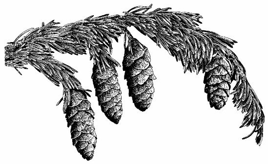
The geographical focus of this book—the North Cascade’s Eastern Slope—also closely follows the range of alpine larch, a remarkable high elevation tree species. The presence of alpine larch throughout the high country of the Eastern Slope is a biological and esthetic theme that will be recalled throughout the book. A line drawing of its foliage and cones, created by Forest Service dendrologist and artist George B. Sudworth, is the icon for the title page of each chapter. His beautifully detailed drawings of dozens of Pacific West trees and shrubs were published in 1908, and are still used by the Forest Service for graphic displays. His illustrations of subalpine fir, whitebark pine, mountain hemlock and Engelmann spruce are also used in several chapters where they relate closely to the text.
Glaciers and high elevation springs from the North Cascade’s Eastern Slope feed streams that eventually become the Wenatchee, Entiat and Methow Rivers, as well as Lake Chelan. This diverse region has a remarkable geographical niche, with its intricate river systems and contrasting moist and dry, high elevation zones. Its plant communities are rich and varied, mirroring differences of elevation and relative distance from the crest of the range. Indeed, the crest of the range creates a major ecological boundary, the transition from uniformly moist areas west and along the crest, to much drier areas to the east, strongly influenced by the rain shadow effect.
East of the Divide combines features of natural history writing, history and essay. The Prologue and Chapter 1 define the physical setting of the Eastern Slope of the North Cascades, and are intended to be part natural history and part narrative on the character of this landscape, both human and non-human. My observations are those one might make while hiking through the basins and along the ridge-tops, with a layman’s approach to landforms and plant communities. Although I have sought descriptions that are scientifically sound, the objective is not science, but rather a synthesis of esthetic appreciation, accurate description, and a sense of wonder.
The goals of Chapters 2 through 13 are to describe the character of this land and the changes it has undergone, through the journeys of more than a dozen individuals. There are differences of time, ranging from the 19th century to the late 1990s. Not surprisingly, each individual has their unique perspective on the wilderness of the rugged high country east of the Cascade divide. Some individuals, such as A.H. Sylvester, who first appears in Chapter 2, will be familiar to readers of Northwest history. Sylvester was the most influential supervisor of the early years of the Wenatchee National Forest, traveling through much of the forest before the trail system was fully developed. His many trips have given us a long list of place names, one of his most enduring contributions. Sylvester died from an accident near Mary’s Pass in the Chiwaukum Mountains, just before the end of the Second World War. Israel C. Russell was a pioneer geologist in the Cascades at the end of the 19th century. His 1897 journey in the Stuart Range is recounted in Chapter 3. Daniel C. Linsley, the most prominent character of Chapter 6, was an engineer and surveyor engaged in a search for a route through the Cascades for the Northern Pacific Railroad. His journal has only recently become well known to regional historians. C.E. Rusk was a well known mountaineer and writer of the early 20th century. His book, Tales of a Western Mountaineer, is a classic of early day Northwest climbing and adventuring. Excerpts from his writing are used throughout Chapter 7, recounting a 1906 trek from Lake Chelan to Glacier Peak, and back. His companion, A.L. Cool, although less well known, was a fascinating individual who spent decades living in the Chelan and Entiat high country. The other individuals from whom I have drawn are known more locally or among specialized circles, but their perceptions and experiences are in no way less sensitive or less compelling. John Charlton and Gene Prater, prominent in Chapter 3, provide some of the most personal and perceptive observations. Also included in Chapter 3, Bill and Peg Stark’s lifelong involvement with the Enchantment Lakes re-affirms the special character of that high, lake filled basin in the Stuart Range. A young woman’s multi-week, solo horse packing trip in the 1930s is recalled in Chapter 8. Her journey is filled with challenges and occasional hardship. Chapter 10 includes the observations of a remarkable mountaineer, Burr Singleton Sr., engaged in reaching the summits of his favorite peaks in the 1960s, even as he approached his mid-80s. Dale Allen’s love of ski touring through the snow covered Cascade high country is expressed with simplicity and without pretense through his journals and interviews in Chapter 12.
Even though I could never have met many of the men and women whose journal entries and adventures enrich chapters of the book, many hours of reading their letters and notes have left me with a strong sense of kinship—both intellectually and emotionally. I believe we share elemental values, and have had many of the same feelings about places and experiences, and we have seen many of the same details of the Cascade landscape. It is my intent that you will be able to share their experiences in a similar way. The final chapter begins with a hike along the top of Icicle Ridge, a striking landform that rises abruptly from the valley floor less than a mile from the community of Leavenworth. Walking along its top is an occasion to consider the value of wildlands, especially those near towns and other developed areas. The relationship of the town and Icicle Ridge can be seen as a model for the compatibility of the natural world with human communities—assuming a strong sense of land stewardship and restraint on our part. The latter part of the chapter is more self-consciously ethical and reflective in character. I describe different approaches to viewing ourselves as individuals and also as members of a species—our shared humanity. A telling issue is how we relate to the natural world in general, and wildlands in particular. What I hope emerges is a synthesis of complementary points of view, where we experience, with a sense of balance, both the natural world and our human created culture: our technology, art, all the substance of our civilization. The existence of intact wildland is acknowledged as fundamental for our species to continue a life of diversity—intellectually, emotion- ally, and biologically. Throughout, my intent is to focus on the genuine experiences, feelings and thoughts one can have in the mountain world of the Cascades.
Prologue
By mid-February the snowpack along the Cascade Crest lies deep. Along the shoulder of Indian Head Peak and Wenatchee Ridge, mountain hemlock and subalpine fir are enveloped by a burden of windblown snow and rime ice, often bent into tortured shapes by the onslaught of white. Even at this late date, the winter’s snowpack has usually not reached its maximum. Most years the greatest snow depth is measured in March, or in some winters as late as April, with depths at Indian Pass and Buck Creek Pass reaching up to 15 feet. Ski touring across either of these passes is a journey into the very substance of a Cascade winter, sharpening one’s awareness of elemental forces, and creating a deep respect for the power and uncertainty of mountain storms. The one time I skied across Buck Pass it was snowing horizontally, and the only shelter for a short rest was a grove of tightly growing subalpine fir, barely dense enough to shield us against the blowing snow. Even though it was the end of March, it was winter, not spring. Because the full force of moisture laden Pacific storms usually strikes the north-south oriented Cascades from the west or southwest, the heaviest precipitation takes place at the crest or slightly west. As the storm fronts are lifted by the mountain mass, much of their moisture falls as rain or snow. East of the divide precipitation diminishes rapidly. In traveling only a few miles to the east, the mountain world begins to change. Most of the moisture has been absorbed by ridges and high summits to the west. This pronounced eastward gradation of precipitation zones, together with their corresponding plant communities, is the starting point—the central theme—supporting and tying together secondary themes and images of this book. It is the single most defining element of the landscape, creating the complex patterns that have made the Eastern Slope of the North Cascades such a fascinating area to come to know.
In 1902, forester and naturalist Fred Plummer described the Cascades in considerable detail, while reporting on the forest conditions of the recently formed Forest Reserves for the U.S. Geological Survey. He spent days hiking through different watersheds on the eastern side of the range, as well as those west of the crest. His observations were grounded upon a thorough training as a forester, and were remarkably insightful. The counterpoint between east and west was evident to him almost immediately:
The climatology of this region must of necessity be written in a very general manner, as the data are of a fragmentary character and not always trustworthy. The general truth is that the western slope is a region of excessive humidity, which with the timber, overlaps slightly onto the eastern slope. The remainder of the eastern slope shows a decrease of precipitation, nearing its minimum in the arid region of eastern Washington... [1]
Plummer was a keen observer and noticed that the character of the Western Slope—in the sense of its plant communities—ex- tends to varying degrees into areas east of the divide, creating a mosaic of plant communities, a landscape with variety and subtlety. What he termed the “botanical summit” was a line that separated the characteristic forests of the west from those of the eastern side of the range.
Upon the large scale map this line would be a band or strip varying in width from four to eight miles, and in this strip the timber features of both slopes would overlap, and this overlap would extend along the eastern slope...In other words, the timber of the western slope has flowed eastward over the geographical summit—freely through the low passes and with difficulty through the higher saddles or over the ridges and peaks.
While Plummer’s description of the Cascade’s precipitation zones—and their respective plant communities—is generally true, a series of elements have worked together to create the distinctive character of the eastern portion of the range. Most are related in varying ways to differences in moisture, but as Plummer suggested, it is a causal web more complex than a simple function of distance from the east/west dividing line. After all, most mountain ranges of the world have a moist, or windward aspect, and a contrasting dry or leeward side. Adding complexity to the texture of the North Cascade’s Eastern Slope are other elements as well, most relating to specific topography. As Plummer observed, low passes allow the effects of moisture laden storms to penetrate farther east than would otherwise be the case, creating areas of lush vegetation east of the crest. High sub-ranges also help to create diversity by blocking moisture and capturing it for their own plant communities, creating islands of surprising variety.
Diversity created by the height and location of sub-ranges is a defining characteristic of much of the Eastern Slope. Standing atop Snowgrass Mountain in the Chiwaukum Mountains one afternoon, I was suddenly struck by what should have been obvious to me years before from simply looking at a map. In this part of the Cascades many of the summits east of the crest are higher, or at least equal to, major peaks lying along the main divide. This is especially evident in the Stuart, Chiwaukum, Entiat, Chelan and Sawtooth sub-ranges, all examples of high elevation outposts on the eastern edge of the range. Because of their height, these summits retain more snow and have a more alpine environment than the casual observer might expect. So, even though the lower slopes of the Chiwaukum Mountains are predominantly a drier, Eastern Slope forest type with Ponderosa pine and Douglas fir, the high basins at the head of Glacier Creek, in the center of the range, are covered with lush subalpine and alpine plants. They are surrounded by rocky, snow-covered cirques where dozens of waterfalls cascade toward moist meadows. Climbing through these hanging gardens early one summer helped me appreciate the smaller scale, more detailed features of the landscape—the vibrant purple of small, moisture-loving shooting stars, and the more subdued, yellow hue of low-lying buttercups.
The overall contrast between plant communities and the variety of landscapes one can explore, are at a peak in Eastern Slope environments. West of the Cascade divide the effects of precipitation are more uniformly pervasive, reducing the effects of elevation and local topography on the character of the landscape and its plant communities. On the Western Slope there is greater homogeneity because of similarities in available moisture. East of the divide the opposite is generally true, where a wider variation in moisture creates environments more rich in contrasts. Often only a few air miles separate moist meadows near the crest of the range, from much drier and more varied landscapes to the east. The transitions are sometimes dramatic and can be magnified by local topography. Even areas very near to one another can be strikingly different. A high, sheltered basin may retain its snow cover through September, its small streams flowing the entire summer, while an adjacent south-facing slope is dry by June. Ribbons of streamside vegetation, where pink monkey flower bloom inches from the water edge, thrive a short distance from matured grasses and other flowers, long since gone to seed. Walking through such a place allows us to become more sensitive to the complexity and beauty of the natural world—helping us understand how different elements of our world fit together, their interrelationships and dependencies. Observing all that is around us becomes an enriching experience, supported by a sense of immediacy, pleasure and discovery.
The geographical alignment of some of the major sub-ranges, and their relationship to one another, likewise affect the east- west variation in moisture. To the north of the Lake Wenatchee country the Cascades widen. There, the Tenpeak, Chiwawa, Entiat and Chelan ranges lie in a northwest-southeast direction. Their acute angle to the Cascade Crest has the effect of lessening precipitation the farther north and east a peak lies. The highest summits of the Entiat Mountains—Mount Maude, Seven Fingered Jack and Fernow—tend to reduce the effects of storms on the Chelan Mountains to the northeast. In a similar way the Tenpeak Range and Buck Mountain can affect portions of the Entiat Mountains.
Along the craggy Tenpeak Range are a series of extensive glaciers draining into the upper Napeequa Valley. Although diminishing in mass over the last two centuries, the range’s half-dozen glaciers are more than symbolic. Lying at the Cascade Crest and several miles to the east, the range sometimes accumulates a snowpack of more than a dozen feet during the winter. Its summers can be cool and overcast, helping to sustain the valley’s ice, and setting the stage for its plant communities and the overall character of the country. Not far away is a different kind of mountain environment. Traveling eight miles to the northeast toward Ice Creek Ridge in the Entiat Range, the snowpack is usually no more than five to six feet, and mid-summer days are often warm and dry. The differences in vegetation, topography and the overall appearance of the landscapes are striking. The two environments evoke different feelings. Comparing the two, and appreciating their differences as well as similarities, will help tell the story of the Eastern Slope of the North Cascades—a mountain world of fascination, contrasts and subtlety. The chapter to follow is a journey through both environments: the upper Napeequa Valley and Ice Creek Ridge.
Chapter One
From High Pass to Ice Creek
Ridge—Contrasting Landscapes
High Pass spans the Cascade Crest a few miles north of the glaciers that feed the upper Napeequa River. Anyone who has not hiked there might think the name plain or unimaginative, but “high” matches the setting perfectly. Forest Supervisor Hal Sylvester, who valued the simplicity of the imagery, gave the name around 1920. When I first walked across its heather and pumice slopes on a clear day in September, the air was charged with the odor of moist pumice soil. If it had been a drizzly or overcast day I might have been looking more closely at individual plants and other details of the landscape, perhaps more aware of the less dramatic, subtle qualities surrounding me. But this day the air was clear and cold. Images were sharp and drew me toward the larger scale aspects of the place, the glaciers, rock faces and steep green meadows. The scene was engrossing, especially for a first time visitor. From the pass I was able to look westward into the upper reaches of Triad Creek, where it begins its fall toward the milky, glacially floured Suiattle River. The creek drops steeply out of sight from Triad Lake, carrying snowmelt to the west of the Cascade divide. Bordered by steep granite and perennial snow, the lake fills a rocky basin sculpted by ice over
thousands of years. Its surface remains frozen and snow-covered until late summer, when its azure water is finally visible. Polished, bare granite surrounds much of the lake. Three hundred years ago, when the Little Ice Age was near full force, the rock outcrops were covered by perennial snow and ice. The slowgrowing meadows above the lake escaped the ice, and as a result, support a dense carpet of heather and dwarf huckleberry. Looking south toward the glaciers of Clark Mountain and the remainder of the Tenpeak Range, the landscape is equally absorbing. The range’s heavily crevassed glaciers are fundamental to understanding the character of this piece of Cascade geography. Their scale is a result of the heavy winter snowfall and relatively cool and moist summers near the Cascade Crest. Even though High Pass is several thousand feet lower than Clark Mountain, its climate is much the same, with a late-lying snowpack determining the nature of its plants.

THE SETTING FOR CHAPTER ONE
The pass’s subalpine plant communities are well adapted to its short growing season. Springtime comes late—often it is mid-July before either pink or white heather is blooming. [1] Other plants flower as well during the short spring: dwarf huckleberry; buttercup; valerian; bistort; and lupine. The most intense period of bloom lasts only a few weeks, although blue gentian will flower late into the fall.

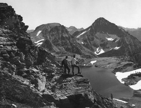
High pass (center), Clark Mountain at left. Dale Allen (far right) and companion.
1959, Robert W. Woods Collection
Even though the long-lasting snow cover explains much of what can be seen at High Pass, other factors play important, if less obvious roles. Beginning over 13 thousand years ago, Glacier Peak erupted and covered the pass, and many areas to the northeast, with smothering layers of pumice. [2] The resulting soil has an unusual texture, helping to create the well drained soil where heather plant communities seem to thrive. Although High Pass is at the crest of the range, its pumice deposits help to make its plant communities ever so slightly similar to areas farther east. Glacier Peak’s height (over 10,000 feet) and its distance of only five miles to the southwest of the pass, may also alter the flow of storms toward the pass, slightly reducing annual precipitation. High Pass is a hybrid, with heavy precipitation, yet admitting some characteristics of the Eastern Slope. Even so, summer rainfall is enough to provide life-giving moisture for its dense floral carpets. Walking through them in a late July bloom is always an experience of joy, even with the ever-present whine of mosquitoes. Their vigor, even after bloom time, gives a lasting impression of how tenacious life forms can be, flourishing amidst the apparent harshness of the mountain environment.
The meadows near High Pass are broken by transitions in topography, forming a setting of some complexity. Cliffs and rock outcrops have created benches and terraces, so its meadows are not as expansive as those near Buck Pass three miles to the north, or Harts Pass in the Pasayten country. But, when all the fragments are summed in the mind as one strolls through the pass, their cumulative scale becomes apparent. Small groves of mountain hemlock are scattered throughout the meadows, especially along the edge of benches, creating a parkland of tree islands. Grove perimeters are sculpted into a krummholz pattern, the low-lying shrub character of conifers affected by harsh, windblown conditions. In places subalpine fir have developed a krummholz around groups of hemlock, using the more snow and wind hardy hemlock as physical protection. In less exposed sites, fir have been able to form their own tree islands without the protection of hemlock. Small differences become important when survival is marginal.
Throughout much of the High Pass area, extensive patches of heather have created a rich mosaic of textures and color, explaining, in large part, why this kind of parkland is so pleasing esthetically. The pattern extends both north and south from the pass, but especially to the north toward Buck Pass. Surprisingly, for several miles north of High Pass the crest of the range is comparatively gentle, with meadow-covered buttes and steep grassy slopes most of the distance to Buck Pass. Rugged Fortress Mountain, northeast of Buck Pass, brings an end to this softer section of the crest.
Mountain Hemlock Tsuga mertensiana, common along the Cascade Crest.
Less than seven air miles east of High Pass towers Ice Creek Ridge, an 8,000-foot rocky spine shading small pockets of ice on its precipitous north side. While scrambling along its multiple summits, it becomes clear what a counterpoint Ice Creek Ridge is to the moisture-rich parklands and large glaciers of the upper Napeequa. Its glaciers are only stagnant hunks of slowly melting old ice, small when measured against the ice masses of Clark Mountain and the Tenpeak Range. Nevertheless, it is no less appealing than High Pass, and in some ways more complex. Even the rock and soil of Ice Creek Ridge seem to have a scent distinct from areas near the crest. Perhaps the lower humidity and mix of plants account for the uniqueness of its smells.
The most telling features of Ice Creek Ridge may not be its vanishing ice, but its groves of gnarled alpine larch, scattered whitebark pine and distant views of the Cascade Crest. Alpine larch are found in the Cascades at high elevations, beginning near the crest and extending eastward toward the edge of the range. Their southern boundary is just south of the Stuart Range, and to the north they reach into Canada. Larch survive in some surprisingly harsh habitats, in high talus slopes or near the foot of permanent snowfields and glaciers, in the very poorest of soils. The species is a remarkable tree. Their light green and delicately soft spring foliage changes to a brilliant yellow/golden during late September or early October. Back-lighting by the low angle sunlight of autumn enhances its color and form, creating some of the most vivid impressions one can experience in the Cascades. Their needles fall by mid-October, sometimes covering the ground already white from recently fallen snow. If an autumn snowstorm is too strong and occurs during the height of color, most of the needles can fall in less than a day. The weight of the snow and force of the wind will dislodge already weakly attached needles.
The species is unusually adaptable and hardy, and is often the first tree to gain a foothold in harsh or recently disturbed environments, where other trees could not yet survive. Larch are the first conifer to grow in morainal areas at the foot of retreating glaciers, surviving in very rocky, bouldery sites, or even in avalanche paths frequently swept by sliding snow. Young larch trees are so flexible they often withstand the effects of avalanche debris bending them out of their upright position. Their flexibility adapts them to less steep slopes as well, where snow-creep over the winter has a similar bending effect, although snow-creep forces act more slowly, over a much greater time span.

Alpine Larch Larix lyallii

Larch trees highlight the landscape along the Eastern Slope.
Jack Wilson collection, 1955.
The larch’s lack of needles gives them another advantage over other conifers during severe winter storms, being less likely toppled or broken by intense winds.
The adaptability of alpine larch allows them to thrive in sheltered locations as well, sometimes becoming the predominant conifer in Ice Creek Ridge’s meadows of partridge foot and white heather. They can grow to a large diameter for a high elevation tree, if located in a suitable habitat and free from major misfortune. Stephen Arno, in Northwest Trees, describes the largest known alpine larch growing on a north-facing talus slope high above Lake Chelan in the Sawtooth Range. This giant measured 75 inches in diameter and 94 feet tall, with a large, spreading crown, perhaps as old as one thousand years. [3]
Over a period of many years—on nearly a dozen occasions—I hiked past a specimen nearly as large in a high basin below Ice Creek Ridge. Its size had always impressed me, especially in comparison to nearby trees. In one sense it seemed out of place, so much older than its neighbors, the twisted, multi-limbed patriarchs that are themselves several centuries old. In a technical sense it may not have been a single tree. Two separate stems may have grown together long ago, and over the centuries developed into a nearly indistinguishable form. In the summer of 1993 I climbed through the basin toward the old tree like so many times before, but this time my emotions dropped. The huge larch was lying prostrate, limbs broken and crushed. I spent some time examining the tree, carefully climbing over its trunk, wondering whether its heartwood had deteriorated and led to its demise. Surprisingly, only the outer shell of its trunk had been sound, and somehow had supported the tree for a considerable time. It had fallen the previous winter—most likely during an intense storm—having lived perhaps a thousand years. Something that survives that long gives us a different sense of time, changing our perspective of place and process.
Another distinctive species, whitebark pine, also thrives along Ice Creek Ridge and similar elevations of the Eastern Slope. Although larch and whitebark are often found adjacent to one another, the two trees are not adapted to identical habitats. To a degree they are complementary. Whitebark often grow along exposed ridges battered by wind, where the winter snowpack is not deep. The winds are too extreme and frequent to allow a deep accumulation of snow. On the snow-rich lee of wind-swept ridges, where wind-blown snow accumulates, is an environment for larch. Their greater tolerance to snow damage allows them to survive. Wind-exposed ridgelines become drought ridden by mid or late summer; whitebark are one of the few conifers that can survive in such a desiccated environment without shelter from other trees. Their success in cold, windy and dry locations helps the establishment of other species, using the older pine as shelter from the most severe conditions. In many cases a krummholz of subalpine fir will develop around the base of a pine, in time moving beyond its protective neighbor.
Under the most severe wind conditions whitebark develop the krummholz form of a large, low-growing shrub.

Whitebark Pine Pinus albicaulis
When conditions are more moderate it shows its more common pattern of a broad, complex crown with either several stems or a single, sturdy trunk. Limbs growing from trees with a single stem can be surprisingly large, sometimes resembling the major limbs of a domestic shade tree.
Because of their life on exposed ridges, whitebark are at risk from occasional lightning strikes, where individual trees are left shattered or burned, or entire groves killed by wildfire. In time these can become outposts of stark, silver-colored snags. One rocky outcrop along Ice Creek Ridge, not far from Carne Basin, is covered with silvered sentinels, symbolic of the role of natural changes so fundamental to the mountain world. Even though whitebark are highly flammable, the rockiness of the ridge kept the fire from spreading into adjacent groves of larch and subalpine fir, enhancing the mosaic-like character of the landscape.
The mountain world of alpine larch and whitebark pine sustains a variety of meadow types, ranging from dry, sparse fescue-covered slopes to isolated basins lush with sedge, grasses and wildflowers. The contrast between well-watered basins and dry slopes is puzzling at first, but becomes more understandable after some observation of the topography. While hiking through Carne Basin, set just below the summit of Ice Creek Ridge, I first began to appreciate some of what was happening. Considerable snow falls in the winter, and although it melts quickly in the early summer from steep, south-facing slopes, on the north slopes a water source is provided that seeps into deep pumice deposits at the lower end of the basin. The pumice soils seem to act like a sponge, slowly releasing moisture, helping to produce luxuriant meadow and streamside vegetation. Move a short distance vertically and you will see vegetation adapted to drier conditions—sparse fescue grass, anemone and aster. In meadows intermediate between moist and dry environments, pink and white heather have become well established, although not with the same dense carpeting that is such a natural signature of the Cascade Crest. Still, on some of the area’s north slopes there are impressive blooms of heather, as well as partridge foot, a frequent ground cover of poor, rocky soils. In places partridge foot creates a solid carpet between boulders, giving a sense of softness to an otherwise harsh landscape. The result may be less luxuriant than along the Cascade Crest, but no less appealing in color, texture and form.
Like High Pass, Ice Creek Ridge has scattered areas of deep pumice soils. Some of its highest slopes are covered with barren, wind-exposed pumice where plants struggle to establish themselves and reproduce. The route to the highest point of the ridge passes through several pumice fields, the highest one dotted with a number of hollowed-out mountain goat beds. The loose and light material makes for easy digging and a soft, forgiving surface for an unequaled goat bed. Climbing across pumice can be difficult for two legged creatures, sliding back a half-step for each step forward. The condition that makes digging so appealing for mountain goats makes climbing slow for humans. Yet, the experience of the summit, its views to the west and north, and the chance to watch goats on the north side of the peak, are a strong incentive.

Larch trees along Ice Creek Ridge.
Buck Mountain and Glacier Peak.
Descending from the summit is unusually relaxing, with loose pumice cushioning each step, evenly absorbing the potential energy gained from the ascent.
The high basins along Ice Creek Ridge are characteristic of the Cascade Eastern Slope landscape. Its topography and variety of plant communities define it as a distinctive mountain environment. The first of several southwest-facing basins along the ridge is Carne Basin, set on the eastern end of the ridge’s sun-drenched side, and nearly 3,000 feet higher than Phelps Creek, a broad U-shaped valley where the basin trail begins in a forest of western hemlock and Douglas fir. Pacific yew, Cascade azalea and myrtle box spread beneath the forest canopy, giving depth and texture to the setting. The climb passes steeply through the lower forest, eventually reaching the zone where subalpine fir become noticeable with their refreshing, resinous scent. A second transition, from forested area to high elevation parkland, occurs quickly, as islands of subalpine fir and whitebark pine are reached, interspersed with huckleberry, mountain ash and asters. A third transition is even more abrupt. In a span of less than 50 yards the steep, rocky slope is left behind as the trail enters Carne Basin. Its shades, textures and morphology are a contrasting pattern to the relatively dry, sunfacing slope the trail has just left. In July the basin is a mixture of brightly colored flower heads and fresh, green, new growth from grasses and sedges. From mid-August through September blue gentian are scattered throughout the basin, adding patches of blue together with the dried seed heads of earlier flowers. Early October adds a thick scent of fermenting huckleberries. By then the basin’s dense, grass-like sedge carpet has turned a brown/golden color, not as brilliant as larch, but just as clearly signaling the drift toward winter.
The trail climbs from Carne Basin, passing groves of larch and open, sedge-covered benches. From this point on, the summits of Chiwawa and Fortress Mountain, rising abruptly along the Cascade Crest, form the northwestern skyline. Several steep, short switchbacks lead toward the saddle between the basin and upper Rock Creek, the headwaters of a 15-mile-long valley leading eastward into drier, more rain-shadowed country. Standing at the saddle it is possible to see other summits to the west: Buck Mountain, Napeequa and Glacier Peaks, as well as the far eastern edge of the range—Rampart and Garland Peaks. Carne Basin is a transition zone between these contrasting moist and dry mountain environments.
The Forest Service maintained, official trail drops slightly into Rock Creek, traversing northward toward Ice Creek Ridge near groves of ancient larch. Just as the upper Rock Creek trail descends toward meadows lower in the basin, a very noticeable, but abandoned trail, continues to the north toward a second saddle. This is the beginning of an old route that follows westward below the summit of Ice Creek Ridge, [4] and in less than two miles passes through two less visited basins west of Carne, similar in vegetation, although not as well defined topographically. These basins rise more abruptly toward the backbone of the ridge, and so retain less moisture and provide a much smaller area for moisture-loving vegetation. Even though on a lesser scale, an oasis of a permanent streams with their ribbons of watered vegetation survives in both locations, even in the driest years.
Ice Creek Ridge, Mount Maude at left.
The band of intense green is bracketed by a broader zone of plants adapted to the drier surrounding environment. By late summer the scene becomes striking, when the dry meadows are tall with mature seed heads active in the last summer breezes. The contrast with lush streamside vegetation is at its peak, defining one aspect of the visual diversity of the Eastern Slope.
By the end of summer, from mid-August through September, gentian are nearing full bloom in the highest basins, one of the latest blooming flowers in the subalpine areas. Unlike many flowers—that might bloom in early summer and only infrequently into late summer in the shadiest sites—gentian sometimes do not bloom at all until it seems too late for blossoms of any kind to appear. Looking at a cluster near its uppermost elevation limit in mid-September, when the first snows could fall at any time, only a few flower heads may have opened. Some of the heads seem weeks away. How enough seed can be produced for longterm reproduction is not clear, yet, it happens, because blue gentian are widespread throughout the Eastern Slope of the Cascade Range.
The hiking route through the Ice Creek Ridge country can be approached from either of two directions. Access through Carne Basin begins at the eastern extremity of the ridge, while a second approach starts to the west, climbing up Leroy Creek into a striking basin below two of the area’s highest peaks, Mt. Maude and Seven Fingered Jack. Their summits rise over a thousand feet above the remainder of Ice Creek Ridge. This second approach is steep and eroded, and by the middle of summer can become unpleasantly dusty. In the early decades of the 20th century the scuffing of thousands of hooves may have made it dustier than today, when large-scale commercial sheep herding was at its peak. [5] Much of the trail system—perhaps more accurately a route—was created during this period of intensive grazing of the high country. The era of sheep herding began at the turn of the century, extended into the 1930s and 40s, and existed to a limited degree in the 1960s. Flocks of several thousand animals were driven to the grasslands of the subalpine meadows.
As the era of sheep driveways waned by mid-century, a new group of visitors began to affect the trail system. Over the years hikers and climbers had used the Leroy Creek trail on their way to and from the upper basin, and as mountaineering grew in popularity, the old sheep trail received even heavier traffic. Leroy Creek Basin has been an ideal base camp for beginning a climb of either Seven Fingered Jack or Mt. Maude, situated like it is between forest and open parkland. Like other sub-ranges of the Eastern Slope of the Cascades, these summits are nearly a thousand feet higher than main peaks to the west on the Cascade divide. The lower slopes of both mountains are patterned with islands of larch, subalpine fir and whitebark pine. Similarly to Carne Basin a few miles to the east, larch have become established in the harshest sites—those with cooler temperatures, deeper snowpacks and poorer soil. In Carne Basin one nearly pure stand of subalpine fir grows on a sun-exposed south facing slope, but below Seven Fingered Jack, the fir are more often surrounding clumps of older larch, with the larch acting as protective islands.
Spectacle Buttes and Upper Ice Lakes from Ice Creek Ridge.
Jack Wilson collection, 1955.
The younger fir trees receive wind protection, shade and a longer growing season from the taller, longer established larch.
In 1960 the northern portion of Ice Creek Ridge was included in the newly created Glacier Peak Wilderness. Further additions to the wilderness in 1984 incorporated the remainder of Ice Creek Ridge, making it an eastern outpost of the 576,865-acre Glacier Peak Wilderness—perhaps the finest wilderness preserve in the Pacific Northwest. It is bounded on the north by the North Cascades National Park, and on the south by the Henry M. Jackson Wilderness, named after a long-time Washington State senator and major sponsor of the original Wilderness Act. Wilderness designation respects the land’s beauty, diversity and fragility. We owe its present protected state to the legacy of public ownership, and the sound decision to preserve this portion of the original North Cascade ecosystem.
My most recent walk along Ice Creek Ridge was on an early October day. I had left the trailhead before 8 a.m., and within a few hours I was beyond Carne Basin, hiking over the saddle that divides Rock Creek from the high traverse along the ridge. Most of the larch were not fully golden, a slight greenish hue remaining on some of the needles, in my view, the preeminent stage of color for larch. Helped considerably by the warming midmorning sun, I was walking through a mountain environment of beauty and enveloping detail. My goal this day was to traverse the upper slopes of Rock Creek, and then reach a high point of Ice Creek Ridge, several miles east of the summit I normally climb. I was interested in exploring a large pumice area near the summit of the ridge, a slope I had been able to see only from a distance on previous trips. The easternmost high point would also give me a different perspective of South Spectacle Butte. I had never climbed it, but from this viewpoint I might be able to sort out a practical route to the summit up its south face.
After leaving the main sheep trail just beyond the saddle, I scrambled through some dense whitebark pine and discovered a secondary sheep trail emerging at the edge of the trees, heading toward the basin directly beneath the high point. The soil was dry, almost dusty where the pines were growing, but after a short distance I was walking on a thickly sodded meadow slope. Even though the meadow was very dry this time of year, the cover of grasses and other low-lying plants had created a nearly continuous carpet of vegetation, mostly dormant now, awaiting the first snows. As the terrain became steeper, rocks replaced vegetation, although scattered whitebark and golden larch dotted portions of the landscape.
The top of the ridge was classic Eastern Slope country. Dwarfed larch were growing in small clumps, punctuating areas of open pumice soil, somehow surviving in this windswept environment. The expanse of pumice continued to the north side of the ridge, eventually merging with patches of ice—the remnants of what had been a fairly extensive glacial system on the north side of Ice Creek Ridge. I could smell the dampness coming off the north slope, presumably from moisture at the interface of the ice and pumice. Sitting on the high point of this portion of the ridge, I could see almost all of the Eastern Slope country, from the Stuart and Chiwaukum Ranges in the south to the Sawtooth in the north. In between, the Tenpeak Range, the Chiwawa country, the Entiat and Chelan Mountains filled in a maze of summits and deep valleys. I spent nearly two hours on the summit, gazing across all this country. It was late afternoon before I dropped into Carne Basin and began the steep descent to the trailhead. Like nearly a dozen times before, visiting Ice Creek Ridge had been richly rewarding.
Chapter Two
The Chiwaukum Mountains—Sylvester’s
Range of High Lakes & Mountain Meadows
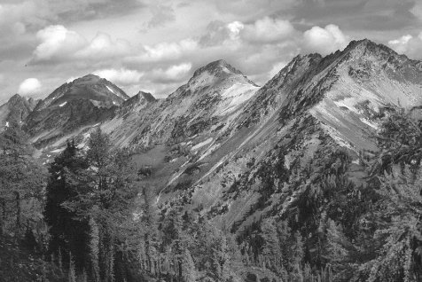
The Chiwaukum Mountains rise to 8,000 feet, the first range south of the Stevens Pass highway corridor, and 30 miles south of High Pass and Ice Creek Ridge. Although at first glance the range might appear less rugged than either Ice Creek Ridge or the summits near High Pass, the Chiwaukums can give a feeling of grandness, especially while hiking into its deepest basins, or across its highest passes. The range is set a considerable distance from other large peaks as well, which further emphasizes the feeling of its mass, and a sense of being in a high and isolated place. Lying little more than five miles east of the Cascade Crest, and thrust a thousand feet higher than summits along the divide, the Chiwaukums support an interesting mix of plant communities, receiving enough moisture from winter snowpack and summer rainstorms to create large areas of lush vegetation. In other parts of the Chiwaukums, especially along ridges and in basins fully exposed to summer sun, plant communities have developed that are adapted to drier environments. Diversity is a hallmark of the range.
As in other Eastern Slope ranges, whitebark pine have managed to survive along the Chiwaukum’s rocky ridges. I have seen them along nearly every ridge in the area, especially in the eastern portion of the range. They are a true mark of the Eastern Slope country. Subalpine fir, Engelmann spruce, lodgepole pine and Douglas fir grow throughout other parts of the higher forested areas. Larch are scattered across many of the highest slopes, especially in cold, north facing basins, giving the area a distinctive look by late September. Larch Lake and the basin surrounding it are bright with golden needles in late September and early October. Larch grow above the lake and extend down the drainage toward Ewing Basin, a place filled with the details of open meadow and parkland, blending to form precise images of Eastern Slope high country.

Glacier Creek basin in February from McCue Ridge.
Even more than larch groves and whitebark pine, what creates the Chiwaukum’s distinctive cast is the absolute variety of plant communities, often observed over small distances. Skiing along McCue Ridge in early April, I was struck by the number of different tree species in less than a mile, and all within an elevation range of less than 500 feet. At the high point of the ridge were scattered groves of whitebark pine, mixed with occasional subalpine fir and spruce. As I dropped slightly to the east I began to see lodgepole pine, and within several hundred yards they became so numerous as to appear dominant—for a short time. I continued along the ridge through a mixture of lodgepole and fir, eventually entering a small opening. At its southern edge was a solitary giant of a Douglas fir, perhaps in excess of two feet in diameter. Its size was unusual for an elevation of over 5,500 feet. It was not tall, but impressively stout and still alive. Nearby was another surprise, a hollowed out ponderosa pine snag, its top broken and now no more than 30 feet tall, with a diameter nearly as great as the fir. Farther down the ridge young Douglas fir became part of the forest mosaic, mixed with spruce, subalpine fir and lodgepole. The whitebark had all but disappeared.
The highest basins of the range—Glacier Creek and the upper South Fork below Snowgrass Mountain—are impressive places to visit. Small glaciers still exist below their rocky summits, although ever since the end of the Little Ice Age, which lasted from about 1350 to 1870, their ice has been steadily shrinking. [1] In unusually dry or warm years, when either winter snows have been below normal or summer temperatures warmer than average, only the old, dark ice of the glaciers still remains by the end of summer. Any accumulation of annual snow that might have occurred in wetter, cooler years is gone before the cold of late autumn stops the melting process. Even so, the Chiwaukums remain an area of expansive basins, waterfalls and high elevation lakes. By early July the rapidly melting winter snowpack creates a rim of waterfalls in the major cirques, equal to the high basins in the Chiwawa or Lake Chelan country farther north.
The range also carries its share of early history. Many of its place names recall the late 19th century and early 20th century. Ewing Basin honors Howard Ewing, a hard-rock miner who spent more than a decade working his claim until his death in 1905. McCue Ridge was named for Rhoderick McCue, a resourceful trapper who began his work in the Chiwaukums in the late 19th century. [2] Sheepherders’ names identify physical features like Knox Lake and Spanish Camp Creek. Early day herders were enamored of the area. They found meadows thick with green fescue, a high country grass growing in large portions of the meadows near McCue Ridge, in the basins along the South Fork of Chiwaukum Creek, and in the Wildhorse drainage. A favorite grazing area was upper Spanish Camp Creek, one of the largest meadow complexes in the Icicle watershed.

HIGH LAKES AND TRAILS OF THE CHIWAUKUM MOUNTAINS
The Chiwaukum Range—running north and south—intersects Icicle Ridge at a right angle immediately east of Frosty Pass, a grand saddle on the western extremity of the ridge. Located little more than three miles from the Cascade Crest, the Frosty Pass country is patterned with meadows, springs and groves of subalpine fir. Looking to the north into Wildhorse Creek from the summit of Frosty Pass, the effects of a wildfire of tens of thousands of acres are still visible. The burn occurred in the late 19th century, sometime between 1870 and 1880, creating large meadow areas, now being slowly reforested in interesting mosaics of old and new. [3] Many of the groves of fir are relatively young, originating after the fire. But where the fire did not pass, refugia of older fir are easily recognized, creating engaging visual shifts. Even today it is possible to see where fingers of fire burned up steep slopes, close to where trees now blend into krummholz. I have stepped over and around old, fallen snags, remnants of the fire, now mostly silvered and beginning to merge with the soil. In place of the old forest, upper Wildhorse Creek is now a parkland of huckleberry, mountain ash, grasses and scattered groves of young larch and subalpine fir. If the fire had been less extensive, the parkland-like landscape would have covered only the higher elevations of the upper Wildhorse.

Chiwaukum Range from near Frosty Pass.

Chiwaukum Range from Rock Mountain Lookout.
1934, Leavenworth Ranger District Historical Collection
For a period of over a hundred years—or at least for several generations of mountain travelers—the Wildhorse fire has given backcountry visitors a visual treat, with some of the largest meadows on the Wenatchee National Forest. Late one fall I was descending from the summit of the high point of the Chiwaukum Mountains, just north of Snowgrass Mountain. Clouds had begun to boil over from west of the Cascade Crest, and were already obscuring the highest summits. As soon as I dropped under the cloud layer nearly the entire drainage was visible below me. I sat down to rest and assimilate as much of the setting as I could. The fallen snag remnants were easy to spot, marking the extent of fingers of forest that had grown up-slope toward the summit prior to the Wildhorse fire. Large patches of huckleberry were autumn-red even in the diminished light. Their abundance is another effect of the fire that must have burned with considerable intensity. Open spaces created by fire became an ideal habitat for the berries, as well as for Cascade azalea, a distinctive shrub that changes into a translucent yellow and orange in the fall. As much as I was enjoying the scene in its present state, I realized the landscape was in transition, like every other part of the natural world. In time, unless other fires occur, many of the lower elevation meadows will become forested.

Ewing Basin in February.
Detailed geographic knowledge of the Chiwaukum Range appears to have developed later than other areas of the Cascades. As recently as the early 20th century, maps were sketchy, and much exploration and ascents of major peaks had yet to be done. One of the pioneers in accurate mapping and place naming throughout the Pacific West—extending from the Cascade Range to the Sierra Nevada—was A.H. “Hal” Sylvester, a topographer for the U.S. Geological Survey between 1897 and 1907. He transferred to the newly formed U.S. Forest Service in 1908, becoming Supervisor of the Wenatchee National Forest. Over a period of more than 40 years he traveled over much of the Cascade Range, and while attending to his duties as an administrator, surveyor and explorer, was responsible for naming many of its geographical features. Sylvester was highly respected in his era for his professionalism, personal integrity, and force of personality. Today he has become something of an icon, the quintessential early days National Forest Supervisor. There is little doubt that his reputation is well deserved. The Northwest historian Harry Majors considers him “one of the supreme figures in the history of the Cascade Mountains”.
Although the Wenatchee National Forest of 1908 was covered by USGS topographic maps, they were not detailed, without many important geographic features and very short of identifying names. As Sylvester relates:
Following my transfer to the Forest Service in the spring of 1908, I was assigned as supervisor of the Wenatchee National Forest and remained in that position until my retirement in 1931 . . . I didn’t contact the habit (place naming) very intensely in the survey . . . Coming into the Forest Service and finding that in fire protection work it was very desirable, even imperative, that the natural features capable of being named should have names as an aid in locating fires and sending in crews to combat them, I began place-naming more diligently. [5]

Subalpine Fir
Abies lasiocarpa

Chiwaukum Range from McCue Ridge, South Fork Chiwaukum Creek (left), Glacier Creek (right).
1934, Leavenworth Ranger District Historical Collection
The Frosty Pass/Icicle Ridge country, which is the southern portion of the Chiwaukum Range, remained one of Sylvester’s favorite places on the Wenatchee National Forest. In late autumn of 1909 he traveled through the area for the first time, naming many lakes, creeks and other features. The journey is a classic of early 20th century exploration and travel in the Cascades—his sensitivity to the beauty of the land is evident. Sylvester’s traveling companion was District Ranger Burne Canby, stationed at the nearby Leavenworth Ranger Station. Sylvester has perhaps remained the most public and well known of all the supervisors of the Wenatchee Forest, even many decades after his death. His legacy of place naming, by itself, has tied him to many features of Cascade geography. Sylvester had a lifetime’s acquaintance with the trails and mountains no modern administrator of a national forest could hope to equal. His knowledge of this mountainous region of the Northwest, and his ability and interest in traveling through it were genuine. Sylvester’s account of the trip follows:
1909 was a bad fire year, but rather late in its fall Ranger Burne Canby and I made a trip into the high country of the Icicle Creek watershed. Trails were very sketchy affairs, or there weren’t any. Rather late one evening we camped in a little meadow well up toward the top of Icicle Ridge. It was cold. We didn’t realize how cold until the next morning when we found our meadow heavily covered with white frost. I hadn’t been giving any names thus far on this trip, but called the meadow Frosty and the little creek that ran through it Frosty Creek. Packing up we rode to the summit of Icicle Ridge (named so later) to a fairly low pass which I called Frosty Pass. We turned east along the ridge and hadn’t gone far when we saw below us in a glacial pocket a beautiful lake of perhaps 60 acres. I had with me a copy of the Chiwaumum Quadrangle which covers the area through which we were traveling and turned to it to find the name of the lake, but lo and behold, it was not shown. The topographers had missed it. I sketched it in and asked Burne what we should call it. He had two sisters, Margaret and Mary. I said, “We will call it Margaret.” We had ridden but a little more than a quarter of a mile further when another lake showed up not very far below us but draining down to Margaret. This promptly became Mary.

A. H. Sylvester, 1930.
Wenatchee National Forest Collection
Frosty Pass lies at the transition between upland forest and parkland, where open meadows blend into scattered trees. This transition has a strong visual effect when approaching from the Frosty Creek side, just as the trail reaches the divide. An expansive skyline to the south, toward Mt. Daniel and Mt. Rainier, and an open view north along Wildhorse Creek, add depth to the setting. Glacier Peak is visible many miles to the north, and nearly the entire Chiwaukum Range parallels the valley’s east side. The range appears especially imposing when autumn snows have touched its upper slopes.
Sylvester and Canby climbed steadily as they left the pass, following a series of open meadow and parkland benches, giving them ever-broadening views. However, it is not so much the distant views that give this place its appeal, but its blend of green meadows, weathered outcrops of metamorphic rock, steep green slopes and streams cascading toward its high lakes. Sylvester continues:
We were in the mountain-meadow type of country now, of which there is none more beautiful. Somewhat tired from several previous hard days, we made camp here for a rest and to let our horses fill up on the best grass we had encountered. The next morning we continued eastward along Icicle Ridge, which shadows Icicle Creek from its head to its junction with the Wenatchee River. We climbed over a slippery shoulder and hadn’t gone far when before us, sheltered under a timbered cliff and glittering in the morning sun, was another lake likewise unmapped and unnamed. Margaret and Mary had a friend, so this became Lake Florence ... I said to Burne, “If we find another we will name it for Mrs. Sylvester.” . . . We rode on past Florence and rounded the shoulder of a little ridge making down from Icicle Ridge and looking across a wide grassy slope, an ancient glacial cirque at the head of a small branch of the Icicle, later called Spanish Camp Creek from a Spaniard who once ran sheep there. We saw glittering through alpine fir and hemlock the other lake already by agreement christened Alice. We were doing pretty well and getting on our mettle. We decided that if we discovered another lake, Flora, the wife of Ranger Green, should have it. Our trail led us up hrough a pass in the main ridge at the head of Spanish Camp Creek, where we looked down on the north slope, and there was Lake Flora on a bench breaking over into one of the forks of Chiwaukum Creek. I had seen this lake on other occasions and from other angles, when its waters were as blue as the other mountain lakes in the region, but that morning, looking down on it from above, because of the angle of observation or particular atmosphere conditions, it was a deep emerald green, very proper under the circumstances.
Sylvester’s travels in the Cascades spanned a period of nearly 50 years. His first Cascade adventure was in the summer of 1897, his last journey was in August of 1944. Those five decades were a time of dramatic change for the high country, when forest roads were extended much farther up many of the major valleys, altering the scale of many trips into the Cascades. While Sylvester’s 1908 pack trip to Frosty Pass began at road’s end just outside the mouth of Icicle Canyon—close to where Snow Creek meets the Icicle River—by the late 1930s trips to Frosty Pass would begin at the Chatter Creek Guard Station, a dozen miles up the valley. [6] By the 1930s and 40s, automobile access, even though not as rapid or convenient as today, was none the less well established up most of the primary tributaries—the Icicle, Chiwawa and Entiat River valleys. Dirt or gravel Forest Service roads had been constructed, placing most trailheads within only a day’s travel from many high mountain campsites. Sylvester’s U.S. Geological Survey field trips in the 1890s often required days of travel with riding horse and pack animal before he could even begin his high mountain triangulation work.
By 1944 Sylvester had been retired from the Forest Service for 13 years, although he had continued to travel on horseback in the Cascades, revisiting many of the areas he had first seen decades earlier. [8] At the age of 74 he led his last trip into the high country, returning with several close friends to the Chiwaukum Mountains and the scene of his 1908 trip. Their plan was an adventurous one, but not out of character for Sylvester even during retirement. The party would travel up Chiwaukum Creek to Larch Lake, then cross the very rugged Deadhorse Pass route to the Wildhorse drainage, and on to Frosty Pass and the many lakes Sylvester had named.
Their first night was spent at forested Lake Chiwaukum, just short of the open meadows of Ewing Basin. The next morning they paused in the basin before continuing up the valley to Larch Lake. It was mid-August, the grasses and sedges were dense and fully formed from a summer of growth. Late summer flowering was at its peak. Bistort, paintbrush and lupine were blooming on shaded slopes. The trail climbs gradually toward Larch Lake, sheltered on a larch spotted bench below a rocky buttress, several hundred feet above the open meadow of the valley floor. Beyond the lake the trail leaves gentle meadow country and climbs up talus slopes toward the third lake in the group. Cup Lake remains frozen for most of the summer, surrounded for the most part by rock and snow. From this point the route was difficult for stock, with steep, rocky and sometimes loose footing, by far the most difficult passage of the trip. After some delays the party crossed the pass and descended into the Wildhorse drainage, the western side of the Chiwaukum Range. By afternoon the group was nearing Frosty Pass, camping at Lake Mary for the evening. Mary is one of the area’s smallest lakes, but its setting amidst meadows and subalpine fir islands, with the steep, green buttress of Snowgrass Mountain nearby, makes it an appealing place to camp.

Near Mary’s Pass, Glacier Peak in distance.
The next morning the group resumed their trip, climbing a steep, switchbacking trail toward the high divide separating the Lake Mary drainage from Spanish Camp Creek. Sylvester was leading the group’s pack string along a steep section of the trail, presumably on the west side of Mary’s Pass. Reports have varied slightly over the years as to their exact route and itinerary, but the consequences of the event have never been in question. The first pack animal’s lead rope became caught under the tail of Sylvester’s riding horse. The horse became excited and eventually bucked, throwing him onto a rocky slope below the trail. His companions quickly realized the seriousness of his injuries, and one of his party left immediately to summon a rescue party. By midnight a telephone call had been made, and the arduous task of rescuing Sylvester began. Dozens of volunteers aided in carrying the stretcher over many miles of trail, eventually reaching an automobile and a transfer to the hospital in Wenatchee. The number of volunteers that gathered in so short a time, even during the earliest hours of the morning, were a tribute to the depth of feeling so many people shared toward Sylvester. In less than a week, Hal Sylvester, who more than any other person had left his mark on this part of the Cascades, was dead.
Over the years I have crossed Mary’s Pass more than a dozen times, and as I have, my thoughts have often turned to Sylvester. The accident has seemed so ironic, occurring at one of his favorite places in the Cascades, and caused by a mishap with his saddle horse. Sylvester was an accomplished horseman, especially in a mountain environment, and he was keenly aware of the difficulties of this section of trail. Thinking back even further, I have also wondered what Sylvester might have felt as he first traveled across the pass in 1908. It must have been an emotional experience, and no doubt a genuine adventure, even if sheepherders had already traveled through the majority of the region. While much of the remainder of our world has changed since 1908, this portion of it has changed perhaps the least, allowing us to experience the beauty of the Chiwaukums—and its emotional rewards—very much as Sylvester.
Sylvester’s importance to the history of the Cascade Range was not limited to his accomplishments with the Forest Service, even though that, alone, is perhaps without parallel. During three summers as a U.S. Geological Survey topographer he climbed over 30 major peaks while performing triangulation work for mapping. During the summers of 1897, ’98 and ’99 he climbed Mt. Stuart, Overcoat Peak, Baring, Columbia, Whitechuck, Sahale, Reynolds, Star, Gardiner and others, spanning what is now three national forests. Much of his legacy of place naming was accomplished while with the Forest Service, and often reflected his interpretations of a physical feature’s historical connections. At other times his sense of humor took control, creating a more whimsical or ingenious interpretation. [10]

The Chiwaukums in the 1950s, 60s and Beyond
August 1955: Our party of eight left the Chiwaukum Creek trailhead still shaded by ponderosa pine and Douglas fir. It was hot and dusty along the first few miles of trail, but eventually we reached the cooler, upland forest after a half-day’s ride on horseback. By late afternoon the scene had changed more than I could have imagined. We camped in a cool, mist-shrouded basin nearly 14 miles from our beginning, near the edge of a meadow basin surrounded by scattered subalpine fir and larch. I had seen nothing like it before. On opposite sides of our camp were two high lakes, Flora and Brigham, less than a half-mile away. Clouds drifted over the crest of the Chiwaukum Range, obscuring their summits, making them appear larger than they really were, especially to a 10-year-old boy taken on his first mountain trip by his father. The ground cover of partridge foot was drenched in mist, the water droplets creating a complex pattern for each plant. The resinous scent of subalpine fir was sharpened by the humidity. Shrub-like fir krummholz surrounded many of the tree islands, giving a sculptured texture to the landscape. Just before dusk the clouds unexpectedly cleared, and we soon spotted five white dots, mountain goats grazing on lichen and mosses below the summit rocks of Snowgrass Mountain.
The following morning we hiked across a low divide and dropped toward the outlet of the nearer of the two lakes. It was small, even for a high mountain lake, with a meadow shoreline for much of its circumference. With some trepidation two young boys peered over a precipice to see the outlet falls plunging into Snowgrass Basin, grasping krummholz branches for some sense of security. The two of us were awestruck. Carefully backing away, we collected our youthful composure and continued hiking around the lake, ascending a boulder field and meadow slope to a cave, looking for what we hoped would be a bear or cougar den. Instead, the entrance was covered with marmot droppings, but even marmots were exciting and new to us. We struggled across a steep talus slope, eventually dropping back to the meadows surrounding the lake, where we could travel without so much effort. In another half-hour we walked into camp with wet feet and boots—the meadows were mist soaked—but we had suffered little other damage. Our parents had given us the freedom to explore our new surrounding with no apparent supervision, and only a few general precautions—a wonderful gift, an opportunity to experience things on our own.

Ladies Pass, with Cape Horn (left), Grindstone Mountain in distance.
ca 1950s, Robert W. Woods collection
On the third morning, most of our group—two boys and six adults—left camp and rode our horses several miles to the summit of Ladies Pass, windswept and cold, but with a clear view of the Mt. Daniel country to the southwest. The pass was a harsh environment with its open slopes, twisted trees and desiccated soils. My jacket was too thin to keep me warm, but I was still able to appreciate much of what I was seeing. Our camp in the green basin a thousand feet below was a welcome refuge from high adventure on a wind-exposed pass. Both images have remained sharp for nearly 50 years.
March 1964: Nine years later I returned to the same location, but this time it was mid-March and my friend Ed and I traveled on snowshoes. Snowgrass Basin was filled with eight feet of snow. The smooth, white slopes of Snowgrass Mountain rose 3,000 feet above our second camp; Ladies Pass was only a thousand feet less. We had snowshoed nearly two days to reach the basin. Even though traveling on snowshoes can be reasonably efficient if the snow surface is not too soft (it is usually good by mid-March), 8 or 10 miles a day with a multi-day pack was about all we could manage as a comfortable upper range.
The first few miles after leaving our car had been easy traveling, simply snowshoeing along a snow-covered forest road. After reaching the actual trailhead (the signpost was nearly buried) we followed the route of the summer trail as much as we were able. As we climbed higher into the Chiwaukums, the depth of the snow sometimes obscured what would have been an obvious trail in the summer. When we lost the course of the summer trail, we followed the line of least resistance, avoiding the worst thickets and trying to adapt to the contour of the terrain. It also helped to have some feel for trail location, or rather, where a trail builder in the past was likely to have constructed a trail. Our best guess was not always correct, but more often than not, we were able to find a reasonable route. Both of us were doing our best to remain on the summer trail, not because we could become lost without it, but because it was likely to be the easiest and most efficient passage.
After a brief but intense snow shower the afternoon of the second day, Ed and I finally entered the lower part of Snowgrass Basin. We found a comfortable campsite well away from any avalanche paths, and next to a small group of fir that could give us some protection from the wind and snow of a moderate storm. Not far away the main branch of Chiwaukum’s South Fork had running water at the bottom of an eight-foot wall of snow. The immediate challenge was to lower a cooking pot on a cord, and very carefully retrieve it without spilling. This required some patience, but was much faster than melting snow. Our first cup of hot soup was ample reward.
Soon after setting up our tent the cloud cover dissipated from the summit of Snowgrass. The sky became a clear and cold blue, especially so against the white mass of the mountain. The snow seemed unusually deep on the upper slopes of Snowgrass; nearly all the terrain irregularities were smoothed and softened. The winter of 1963-64 had been a big snow year, much above the 50- year average. Ed and I felt lucky to be there at such a time—the beauty of the landscape deeply impressed us.
The following morning was overcast and threatening, but I wanted to climb the remaining distance from camp to the basin between Lakes Flora and Brigham, and, if possible, beyond the basin to Ladies Pass. Several inches of new snow had fallen overnight, but not enough to make traveling difficult. The basin between the two lakes was well sheltered from wind, but the quiet was unexpected, and for a moment, almost eerie. Most of what I had remembered as a ten-year-old boy was covered by a white, muffling blanket. Only the subalpine fir and needleless larch gave form above the contours of white. I was thoroughly captivated with the scene, even during the last thousand-foot climb through fog to the summit of Ladies Pass. I could see nothing but the wind-packed snow where I stood at the pass, but I knew I had returned to the scene of my first adventure in the Cascade Range.
During the next three summers I visited the Chiwaukum Range several times, spending most of my time in the vicinity of Snowgrass Mountain and the high meadows between Frosty and Ladies Pass. Early July on the sunny slopes below Snowgrass proved to be a remarkable time. The majority of the previous winter’s snow had melted, yet patches remained in the more sun protected locations. Yellow glacier lilies, in full bloom, created a carpet between groves of subalpine fir. At the edge of snow patches a short distance away, immature lilies were pushing their way through a few inches of granular, springtime snow. In the sunniest areas the lilies had already faded, replaced by a mass of ground-hugging buttercups. In nearby rocky outcrops white and pink phlox were still blooming with their dense mats peppering the ground. Only a few feet off the trail the ground seemed fresh and vibrant with so many signs of early summer.
As I left the Mary’s Pass trail I climbed a steep meadow toward Snowgrass, passing through an upper basin with dozens of clear pools fed by patches of melting snow. The meadow plants were responding to the sudden arrival of spring and the absence of snow. Sunlight and moisture had combined to create a basin full of the colors and textures of a complex community of plants. I continued climbing through the basin, eventually reaching the upper slopes close to the summit ridge. I was surprised to be walking through a slope sufficiently moist, even though windswept, to support a vigorous field of lupine nearing full bloom. Their scent was strongly aromatic. Above the lupine was a slope filled with a dense cover of tall sedge, flowing in a brisk breeze. Sitting down for a few minutes, I concentrated on using all my senses. I wanted to smell, see, hear and even touch as much as I could of what was around me.
The summit ridge was higher, more exposed and rocky. Only a few alpine plants were able to survive, but they were in bloom as well. Evening was approaching, so I began the descent after a few moments, stopping once more at the sedge flowing in the wind, looking out along the ridge line toward the southern end of the range. I understood, quite clearly now, why the Chiwaukums had been one of Sylvester’s favorite places.

Chapter 3
The Stuart Range—
Granite Crags and Alpine Lakes
The Stuart Range is a mass of exposed granite aligned east and west, no more than 10 miles long, carved by Pleistocene glaciers into spires, glacial amphitheaters and polished rock basins. The main tributary valleys below its pinnacles and cirques—Icicle Creek to the north and Ingalls Creek bordering the south—were deeply carved by glacial ice and show the U-shaped profile distinctive of valley glaciers. Icicle Canyon is one of the deepest valleys in the Cascades, rivaling shaded, green valleys farther north. Nearly 7,000 feet in elevation separate the summit of Cannon Mountain from where Rat Creek, flowing off the northeast flank of the peak, finally tumbles into Icicle Creek. The range’s high point is Mt. Stuart, located at its western extremity, with Mt. McClellan at the eastern boundary and a thousand feet lower. Positioned nearly 20 miles east of the Cascade Crest, these peaks catch just enough snowfall to supply a dozen or so small glaciers on their protected, north facing cirques. During the height of the Pleistocene Ice Age, glaciers from these summits and nearby high elevation plateaus (the Enchantment and Rat Creek Basins) flowed down the Ingalls and Icicle Creek canyons. [1] The Icicle lobe extended into the Leavenworth basin, even covering a rock knob near the edge of town where my home is located.

Primary Travel Routes Through The Stuart Range
Roughly 18,000 years ago the ice of the Pleistocene maximum began to melt. A landscape began to take form that now has a remarkable diversity of form, texture, color and plant communities. The ice had sculpted granite crags and spires, steep walled cirques and polished granite basins now filled with crystalline lakes. For over 10,000 years after the glacial maximum, the climatic trend brought generally warming temperatures, with smaller scale climatic changes adding variation to the overall pattern. Around 5,000 years ago gradual cooling began, again with smaller scale warm and cool cycles. [2] The Little Ice Age of the 14th-19th century was the latest of the cool cycles, returning a moderate amount of ice to the highest basins of the Stuart Range, although the ice was not so widespread as to interrupt the continued development of the range’s high elevation meadows, stands of whitebark pine and groves of gnarled larch growing there now. Today there is only a fraction of the ice that existed at the height of the Little Ice Age. (See Chapter 4)

Ingalls Lake and Mount Stuart’s west ridge.
1897, I. C. Russell party.
With the exception of pockets of lush meadows in especially moist habitats, most of the plant communities in the Stuart Range are adapted to relatively dry conditions. This is especially true at exposed, higher elevations, where wind desiccation has a major influence on moisture available for plants. At the upper limit of their life zone near 8,000 feet, conifers become dwarfed and twisted from the forces of wind and snow. Krummholz of larch and whitebark pine struggle to survive near Aasgard Pass, finding small pockets of raw soil between granite boulders. The lower valleys of the range are densely forested on north slopes; south-facing slopes support more open stands—sometimes park-like—of ponderosa pine and Douglas fir. The upper basins and ridges are often an intermingling of meadows, larch and granite—a blending of contrasting textures and colors.
Regardless from what direction someone first sees Mt. Stuart its effect is always powerful. Rising 500 to 1,000 feet higher than the remainder of the Stuart Range, its distinctive arrowhead shape is recognizable from nearly any angle or distance. The pioneer geologist Israel C. Russell, visiting the area in 1897, was impressed with his first sight of the mountain’s steep granite walls: [3]
The light color of the naked granite gives the precipices and crags a seemingly white color when seen from a distance, and produces a striking contrast with the dark and more varied shades of the encircling mountains of gneiss, serpentine, greenstone, etc. The summit of the granite mass, except where it has been smoothed by glaciers, is rugged and serrated . . .
Russell did not climb to the summit, but did scramble to a rugged saddle on the mountain’s west shoulder (now called Goat Pass) from where he could see Stuart’s frozen side:
On the north side of Mount Stuart, and 1,000 feet below its summit . . . there are three small glaciers, situated in steep gorges or clefts in the granite and sheltered by outstanding cliffs.
Russell showed equal respect for the south side of the range:
The group of rugged peaks composed of Mount Stuart granite are precipitous on all sides, but especially so on their southern border. . . in no place can the summit be reached without true mountaineering.
Russell’s party spent some time at what is now called Ingalls Lake, relaxing and absorbing the scale and setting of the mountain. Their 19th century photograph of the lake and Stuart’s West Ridge, reproduced for this chapter, gives only a suggestion of what Russell experienced on his reconnaissance.
Mt. Stuart’s north face, with its sheer granite mass and hanging glaciers, added to the north side of the remainder of the range, are by some measures as imposing as any series of summits in the Cascades. The combination of glacial ice and continuously steep rock for thousands of feet, make one wonder at the physical forces that created such mountains. Even the sunnier, south side of the range is an impressive show of granite. Although not as steep along its entire slope, rock on the upper half of the mountain’s south face can still be challenging to climb. The mountain’s lower south slopes are an interesting contrast, a mosaic of meadows and groves of whitebark pine and Douglas fir, set beneath granite outcrops reaching upward toward the summit.

Mount Stuart’s north face, Sherpa, Ice Cliff, and Stuart Glaciers.
1955, Jack Wilson Collection
From Turnpike Meadow, below the south side of the mountain in Ingalls Creek Valley, Mt. Stuart’s granite mass rises 5,000 feet. By mid-May the meadows are covered with the vibrant yellow of glacier lilies, blooming just as the last snow melts, or sometimes just before, pushing through the remaining inch or so of the winter’s snowpack. High up on the peak, the knife-edge ridge between the false summit and the true summit is still frozen with a winter coating of snow, usually with large cornices over-hanging the north face. A month later, by mid-June, Stuart’s south side has entered late spring. Snow has melted from the lower slopes, but high on the peak the ascent remains a steep snow climb. These were the conditions encountered by two energetic individuals as they climbed to the summit in June of 1897.

Mount Stuart’s south side.
1955, Jack Wilson Collection
A.H. Sylvester and his assistant J.J. Charlton were doing survey work for the U.S. Geological Survey in the Stuart Range the same summer Israel Russell was first exploring the area’s geology. Their climb to the summit, needed as a triangulation point for their work, was one of the earliest ascents of Stuart with an excellent journal account. [4] Sylvester had worked several years for the U.S.Geological Survey, and by 1897 had become an assistant topographer, working along the Pacific Coast south of the Columbia River. He now had the responsibility of doing survey work in the Washington Cascades. His companion, John Charlton, was not only a capable outdoorsman, but also showed a considerable sensitivity for the mountain environment, and conveyed some of his feelings through journal entries. Sylvester commented in later writings about his very capable companion: [5]
My assistant was John Charlton, a young school teacher of Ellensburg, grown up in the knowledge of the handling of horses and acquainted with the outdoor life of the mountains. Companionable, intelligent, active and strong, he was splendidly equipped mentally and physically to be companion, guide and friend to one who was still more or less of a greenhorn.
Below are excerpts from Charlton’s journal, describing their approach to Mt. Stuart, his general impressions of the physical setting, as well as his reaction to the rigors of climbing to the summit and accomplishing their official duties. Charlton was noticeably affected by the mountain environment of the Stuart Range:
June 21, 1897 - The scenery coming up the Teanaway is very beautiful, in some places grand, but the climax of grandeur was reserved until we came to the base of Stuart which loomed 5,000 feet above us. Put up camp tent in a hard rainstorm which was preceded by a few sharp claps of thunder. Not a dry garment on. On the first day fit for observations we intend to climb Stuart. Raining hard.
11:00 p.m. 22nd - During the day several thunder storms accompanied by rain, passed. I like the roll of thunder. In it there is a sublime music which overcomes one with a feeling of awe. As I listened to the storm today here at the foot of a mountain reaching over 9,000 feet high and surrounded by peaks nearly as high there is a grandeur in a thunder storm which I never felt before.
June 25 - Today we climbed Stuart and ate lunch on the summit. Six hours were required for the ascent as we were heavily loaded, having the theodolite weighing about 45 lbs. Our way led over some very rough rocks and over one glacier and 2 or 3 snow drifts across which we lined. In some places we were obliged to creep around cliffs where a slip or misstep would have sent us down from ten to two thousand feet. I confess I did not relish the work. Owing to clouds in the north we could not take any observations so left instruments on summit and will go up some clear day to finish work.
28th - I am now sitting on the summit of Stuart, which we reach at 9 a.m. We started from camp at 5:27 a.m. and climbed the 5,000 feet in 3 hours and 33 minutes. The day is beautiful here. There are, in sight from here five great mountains: Rainier, Adams, and St. Helens in the south and Baker and Shuksan in the north. The Olympics are visible across an ocean of fog which covers the Puget Sound country. We finished work on Stuart and started for camp at 6 p.m. We had about 2 and 1/2 hours of daylight remaining and a heavy load to carry. We lined over the glacier which is quite steep and crossed our roughest road in good time. My load being heavy I determined to try coasting down on a snow bank. Sitting down with jeans for sled, guiding myself by a pike I had a pleasant ride for 1,000 feet and there sat and rested until Sylvester, who was scared by feeling the snow through his jeans, clambered over rocks and ledges down to where I was. We arrived in camp at 10 o’clock after which we had supper and now at 11:50 p.m. we are ready for a good nights rest.
Their route to the summit was the large, south side alluvial and gully system east of what is now called the Cascadian Couloir, the most frequently climbed route of recent decades. The Cascadian Couloir and the easterly, gentler route, merge about 1,000 feet below the false summit, where both gullies widen into an open but very steep fan. Its most severe section approaches 40 degrees, steep for a non-technical climber on smooth, hard snow. In May or June, when considerable snow remains near the summit, this portion of the climb requires both skill and care. When the snow surface is firm, climbers at this point usually rope up and use crampons, and proper use of the ice axe is essential should one slip. It is not a slope to treat cavalierly, especially when climbing boots barely dent the hard snow surface during early morning ascents. Over the years, uncontrolled falls have been disastrous to several climbers, after plummeting into the exposed rocks below the steep, upper section of the climb.
After reaching the false summit, climbers must work their way along the mixed rock and snow of a corniced ridge toward the true summit. The north face of Stuart drops severely from this point. In May or early June large, overhanging cornices add to an already dramatic alpine scene, intensifying the impression of a vertical, north wall. The final ascent to the summit is steep but quite short. The summit block of granite has enough room for three or four people to rest and peer over the precipice to the north. Lake Stuart lies 4,500 feet below, surrounded by forest, meadow areas and sections of brush and large granite boulders. For many mountaineers, the view of the lake’s green borders and its clear, blue color, provides the ideal counterpoint to the cold snow and granite of the summit.

Ascending Mount Stuart below the false summit–Charlton’s route.
Mt. Stuart’s summit is a spectacular place, even if it sometimes appears overwhelmingly austere. Later in the summer, when most of the snow from the south side and summit ridge has melted, the climb changes into more of a loose rock and boulder obstacle course. The adventure and beauty of the frozen snow are gone, although the climb is no less a physical challenge. However, the north face of Stuart retains its frozen, glacial character for the entire year. The Stuart, Sherpa and Ice Cliff glaciers have diminished since the recent maximum of the Little Ice Age, but they remain impressive masses of alpine ice. The Stuart Glacier is the largest in total area, and is in clear view from the marshy meadow beyond Lake Stuart. Bouldery alluvials extend from its most recent moraines to just above the meadow, creating direct access to the apron of the glacier.
Although it is not as easily seen, and from some angles hidden by a secondary ridge, the most interesting ice on Stuart is the Ice Cliff Glacier. For much of its length its ice is steep and bracketed by two nearly vertical granite ridges, with a great ice cliff near the mid-point of its mass. A finger of 60-degree ice reaches toward Stuart’s false summit. This route up the mountain’s north side was first climbed in August of 1957 by three individuals who did much of the naming and pioneering of climbs on Stuart, as well as other peaks in the range: Gene Prater, Bill Prater and Dave Mahre, then residents of the Kittitas Valley. Gene Prater’s account of their experience tells of the challenge of their climb and the eventual fatigue and humility they shared. [7]
They began their climb by hiking up the Eightmile and Mountaineer Creek trails to within a mile of Lake Stuart. At this point they traveled cross-country, camping just below the north face of Mt. Stuart. Their climb was a decade before late-1960s road construction shortened the approach hike. Gene Prater’s narrative continues:
We camped at the last trees, below the central glaciers of Stuart’s north side, which by token of the 100-foot cliff from wall to wall of its trough, we call the Ice Cliff Glacier. A hard rain storm all night kept us in camp until 7 a.m. when the rain stopped, but the clouds remained at about the 8,000’ level. The rain also lubricated the glacier . . . so we heard and saw numerous seracs tumble and roar down the ice below . . . we scrambled to the U-shaped moraine above camp, which has ice solidly within it and then up the black ice on the left side of the 1,000’ section below the ice cliff. This can be tough climbing and we used several ice pitons, in one place taking direct aid from them on a vertical pitch. Since the ice cliff appeared unstable, with fresh blocks of ice which had fallen from it filling in the area between seracs and fins of ice just below the cliff, we crossed singly at a dash to the rock wall on the left side of the glacier.
They removed their crampons and climbed around the ice cliff on steep rock, using several pitons for protection. Now that they were on the upper glacier a second series of obstacles was encountered, a double bergschrund (crevasses near the ice edge, close to the rock) separating them from the upper snow chute. These were also bypassed by climbing onto the steep rock, finally giving them access to the upper glacier.
After a brief lunch stop, we traversed left and got into the 1,200- 1,300 ft. long snow gully, 60 degrees steep. Ten belays got us to the top . . . the angle never let up and short places where it steepened, definitely were steep.
It began to rain lightly as they reached the ridge leading to the false summit, but they were relieved to see that the summit was nothing more than an easy, even if long, scramble. While very tired, they were deeply satisfied with their effort, although the climb had taken longer than expected and darkness was approaching. They quickly dropped toward the east and began the long trek back to their camp, much of it in the dark.
We descended in the south east gully between Stuart and Sherpa Peak, the peak to the east, traversed under it and climbed slightly to the pass east of it, which we now call Sherpa Pass. We descended from this pass into the 3rd fork of Mountaineer Creek . . . we named this branch the Sherpa Fork. Darkness having overtaken us and fatigue getting worse, any lapse of imagination in giving place names to areas previously unnamed is hereby explained. Midnight saw us back at camp, where we heated some grog and started out . . . the 25th hour, after leaving camp to begin the climb, found us back at the car at the 8-mile Creek bridge, bathing tired feet in the sparkling Icicle. When dawn comes, force of habit makes a man feel as though he is starting a new day, even if he is really just continuing the new day from the previous one, with no sleep or rest.
The north side of Stuart remains a spectacular, rugged and harsh climbing environment. While the Stuart Lake drainage is now part of the “managed” wilderness of permits, the wildland south of the official trail system—below the awesome north face of the range—is as challenging and inspiring to visit as it was when Gene Prater first gazed toward the Ice Cliff Glacier, and wondered how he might climb it.
The Enchantment Lakes
Except for perhaps the sheer mass of Mt. Stuart, the outstanding feature of the Stuart Range—what Israel Russell first called the “Wenache” Mountains [8] —Is the Enchantment Lakes, a series of glacially carved, stair-stepped basins beginning at nearly 8,000 feet below Dragontail and Little Annapurna peaks. This ice-sculpted wilderness is laced with small meadows, lakes, waterfalls, polished granite and alpine larch. In the lowest of the basins are three of the larger lakes, bordered by granite, pockets of snow and groves of larch. From the outlet of the first lake, Snow Creek drops abruptly for over a thousand feet, and then flows at a slackening pace into the upper of the two Snow Lakes, relatively large lakes for their elevation. In this transition one leaves an environment of small lakes, gnarled trees and cascading streams for the less unusual although still imposing Snow Lakes Basin. Even here the granite mass of Mt. Temple rises 3,000 feet above the lakes.

Snow Lakes, Enchantment Basin (top center), with Mount McClellan (left), and the Temple (right).
1955, Jack Wilson Collection
Israel Russell looked toward the eastern edge of the Enchantment Basin in 1897 when he hiked to the crest of the high ridge south of Snow (Twin) Lakes. Presumably, he was seeing Mt. McClellan and the granite slabs that lie between the lowest Enchantments and upper Snow Lake. He described the landscape with a geologist’s eye: [9]
The bare white granite is fresh or but slightly weathered, and in many places preserves the glacial polish and striations given to it by flowing ice . . . in the eastern portion of the range a magnificent amphitheater has been hollowed out . . . . In the more elevated portions of this amphitheater there is still a small glacier, below which, and at the bottom of a steep, bare slope of polished granite, there are two rock-basin lakes, known as the Twin [Snow] Lakes.
Russell’s perspective from the ridge-top did not allow him to see the complexity of either the middle or upper portion of the basin. Evidently, he did not have sufficient time for the several miles of rugged travel, requiring descending and ascending in both directions, to reach the Enchantment Basin. Another pioneering U.S. government employee, A.H. Sylvester, had that opportunity, and his name for the area has lasted. Like so many of his other journeys, Sylvester had a unique trip into the Enchantments in the early 1900s. Surprisingly, the basin had not yet been placed on U.S. Geological Survey or Forest Service maps. He describes his first visit there: [10]
. . . on a trip I made on foot, the only way, into the head of Snow Creek in the Mount Stuart Range. There are two fine lakes . . . near the head of Snow Creek called Snow Lakes. I camped between them overnight and the next morning went on up the creek to see what I could see. There I found five or six most beautiful small lakes grouped in a wonderful little glacial valley all ringed with alpine larch. From the highest up over an entrancing fall tumbled the water it received from a small glacier. It was an enchanting scene. I named the group Enchantment Lakes.
Because his description of the waterfall so closely matches a falls that plunges into the larger of the middle Enchantments (now called both Rune and Perfection Lake), it is unlikely Sylvester reached the upper basin on this visit, his first to the area. The Snow Creek Glacier covered more of the upper Enchantments than it does now, which may have discouraged him from hiking toward the two summits that border it. The early 1900s were nearer chronologically to the extensive ice of the Little Ice Age, giving the high country of his era a greater snow and ice cover than I have seen in my lifetime.
Although Sylvester named the area and placed it on early Forest Service maps, not until the middle of the century were the Enchantments more widely known as a special parcel of the Cascade’s Eastern Slope. At that time two individuals became inextricably involved in the character of the place. In early August of 1959 these two remarkable people hiked through the Enchantment Basin on the first of many journeys. For the next 33 years they visited yearly, sometimes as often as four times in a calendar year. Only during November, December and January have they not camped within the high, ice-sculpted granite basins. William and Margaret Stark, known as Bill and Peg to their friends, have created a unique relationship with this high mountain world at the eastern edge of the Stuart Range. Years of intense study and love for the area have given them a knowledge that is unusual in its depth. A large portion of their lives has been devoted to exploring, experiencing, photographing and thinking about this singular place. Being there over the decades has been so rich an experience, that it has changed the substance of their lives.

Middle Enchantments
1954, Jack Wilson Collection
Those of us visiting mountain ranges and other wild places throughout the world are often struck by grand, expansive vistas, entire landscapes that are vast in their scale, drama and beauty. The Starks have shared experiences like these in the Cascades and elsewhere, but that is not their way of seeing the Enchantment Lakes. Even though they have been powerfully affected by imposing scenes in the basin, what has most impacted them is the interrelationship of details, the smaller scale beauty of complex textures, colors, shapes and sounds. They have studied the changing patterns of plant life throughout the area, ranging between extremes, from the bleak, windswept slopes of the upper basin, to protected groves and meadows around the lower lakes. Coming across pioneer plants while walking in the upper basin, Peg wrote in How Deep the High Journey: [11]
I was stopped by the sight of an old acquaintance. It grew in the gravel at my feet—a tiny blue flower. I dropped to my knees for a closer look, and sure enough it was lupine, a very miniature lupine. I have seen other miniscule flowers at these altitudes, even a tiny specimen of orange paint brush. I knelt before it too, cupping my hands around it, pretending it was the wind that brought tears to my eyes. . .this bright, infinitesimal banner of life defying the onslaught of the relentless wind, growing to all the stature that bleak environment allowed.
More of their time was spent in the lower and middle lakes, becoming familiar with the plant communities of its more benign environment. Even here, granite was a predominant and defining pattern, but pockets of soil, some of substantial area, provided the basis for a complex pattern of life:
In more protected places farther down the mountain, small tufts of grass catch in pockets of granitic soil. Then a rivulet of growing green runs down the crack of a rock, and the hanging gardens begin. High above Crystal Lake to the west, with rock below it and a ridge above it, a terraced garden grows along the ledges, gentling the castle walls around the lake . . .All down the lower basin pocket meadows and small, secret forests lie at random . . .the tapestry changes every day in texture and color.
During their earliest trips to the basin, it became apparent to Bill and Peg that while alpine larch is the predominant tree throughout the Enchantments, both visually and in an ecological sense, other tree species play prominent roles in the mix of plant communities. Other species provide a background of contrasting color, shape and even feel, enhancing the unique qualities of larch. Their interrelationships create a visual and ecological pattern that Bill and Peg Stark found intriguing. Again, Peg describes the variety they saw and felt, as they explored the total landscape:
Sometimes farther up the basin I confuse fir and spruce until touch proves spruce as sharp as juniper, for both spruce and fir have a bluish tinge to their densely growing green. A richer green and a graceful, drooping top distinguishes the occasional alpine or mountain hemlock. East of Merlin’s Tower is a grove of them laden with tiny cones covered with needles in soft rosettes. Whitebark pines show themselves to be trees in other ways. Often no taller than the firs, they stand apart, perhaps to leave room for their branches to spread. They frequently seem to have more than one trunk, or to have one branch that curves out and then up . . .This way of growth is illustrated in an exquisite natural bonsai rooted in a crack of a wide rock in Magic Meadow. Three more flank a graceful larch standing with trunk stripped of bark to the windward on the bank of Rune Lake.
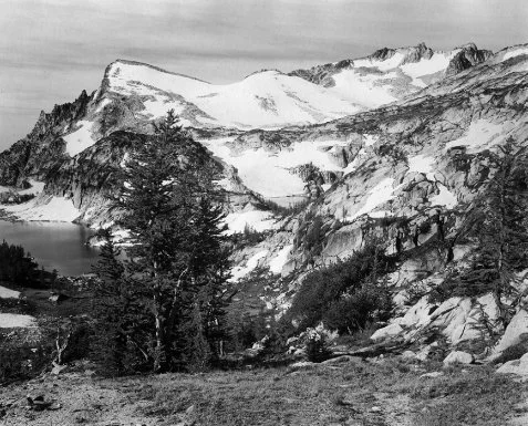
Larch trees below Prusik Pass, Little Annapurna (left).
1954, Jack Wilson Collection
Not withstanding the whitebark pine, fir, spruce and occasional hemlock, larch is the defining tree of the Enchantments, symbolic of the whole area. This has been true for the Starks, as well as many others visiting the area. In the winter and early spring larch are bare and seem lifeless. Their lack of needles helps them withstand the harshest of winter winds. Larch limbs are rough to the touch that time of year, with nubbins along their length marking where soft, light green needles will grow in June. In early summer the tops of larch will be leafing out new needles, even as the lower parts of trees are still covered with several feet of snow. The fresh, summertime foliage is light and graceful, perhaps the softest of all conifer needles to the touch. On warm summer days their scent is noticeable throughout the lower basin, especially near the larger groves. Even though larch trees are a pleasure to see and touch during the summer, enriching the Enchantments biologically and esthetically, it is not until the end of September that one begins to see them at their final, intense phase. Bill and Peg Stark did not know about golden larch as they began hiking into the basin early one October, their first autumn journey into the Enchantments. They were rewarded by an experience so compelling, that they chose to return every autumn for the next three decades, each time renewing that initial experience. Again Peg writes:
Sometime in September the larch trees that stand so unobtrusively in their tender green begin a transformation. Their green pales, then yellows—a few needles, then whole branches turn day by day, hour by hour. As the days shorten the lower basin seems to prepare itself to catch each remaining glimmer of sunlight. By Indian Summer, those bright days that usually come in the last few days of September or the first two weeks in October, the larch stand robed in needles of pure gold . . .Every stream, every lake edge was fringed with fallen needles....The days are short in October, but at no other time is there such an interplay of sun and earth. Larch trees at Viviane catch the rising sun . . .The eye is lifted to an intensity of blue, framed in golden boughs.
Autumn has been the quintessential time for the Starks to visit the Enchantment Basin, or for that matter, the time of year that they are most likely to think about the place, and recollect nearly a lifetime of impressions. Even in inclement weather, without direct sun, it is a time and place of compelling beauty. Gold, yellow and light green hues, although subdued, create intricate patterns with cold granite and patches of early October snow.

The Enchantment Basin and its Approaches
Like few others, Bill and Peg Stark know the Enchantments in depth, in part because they have traveled there during winter, as well as the less demanding times of spring, summer and autumn. Without that experience, one aspect of the landscape would be missing, although it is a time when the world at first glance may seem meager, almost a monotone whiteness. As a species we sometimes demand less disguised visual stimulation to maintain our interest. Unless it is a blazingly clear day, with the sharp contrast of sky against snow and rock, it may take time for us to appreciate what is there to see. Seeing the more subtle aspects of our world requires patience. During one February snowshoe trip Bill and Peg experienced the austere whiteness of the Enchantments, the character of the country in mid-winter. Again, Peg writes:
February weather can be fickle . . .The clouds seemed to be coming to us or we to them. The snowy horizon blended with the sky. There were no shadows. All contours and slopes were swallowed in a white flatness. Across the whiteness at wide spaced intervals fine lines were drawn and, following these, rows of shadowy trees, exquisitely delicate. Ridge tops were hinted at by the merest blur or did not show at all . . .As we went on trees appeared and disappeared, as if a curtain were parted for a moment then closed again . . .The Japanese island was revealed on Rune—alone in the white—and I felt myself looming beside it in a Lilliputian land. I came upon a ghostly gathering of bigger trees and was myself diminished. All the while, wandering through this closing and disclosing mist I felt a mixed sense of apprehension and expectancy—always on the edge of something.
In the afternoon they returned to their sheltered camp at Lake Viviane. By then snow was beginning to fall, and continued into the evening and early morning. Their tent was partly protected by a large, lichen-covered granite monolith that they had named Merlin’s Tower. By morning the wind was swirling around the tower, dropping fresh snow onto their tent, letting them know the weather pattern had changed. Bill and Peg climbed to the ridge-top above their camp where they could look westward toward the summits of the upper basin and Aasgard Pass. The skies had become clear, while the wind continued to be very strong, buffeting the ridge-tops, especially the summit of Mt. McClellan. Blowing snow had drifted into different shapes and textures. In places the force of the wind-driven snow sculpted and eroded the old snow surface into curved patterns. Above it all the sky was sharply blue.
The next day Bill and Peg began climbing into the upper basin, intent on reaching the summit of Little Annapurna. The sky was still blue as they climbed out of the lower lakes, but began to turn gray as they neared the upper basin. They continued climbing, but just short of the summit, stormy weather returned with some seriousness, forcing a retreat. Again, the basin was covered with more snowfall. Peg continues:
When we left the next day, I stood for one last minute at the outlet listening again through the silence, through the thickness of the ice and the softness of the snow, to the song of buried water flowing beneath me. We started down—and were blessed by a shower of snow while the sun was still shining, so that a dust of diamonds floated around us. I knew that in a few short hours our tracks would be covered. All sign of us would be gone.
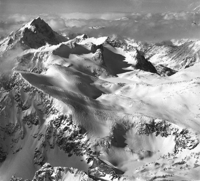
Upper Enchantment Basin in winter, Mount Stuart (upper left).
1970, Wenatchee World photo
One long-lasting consequence of Bill and Peg’s presence in the Enchantments is their imaginative system of place names for many of the lakes and landmarks throughout the basin. Although several of the larger lakes had been informally named by groups of climbers in the late 1950s, within several decades Bill and Peg’s system of naming was used by the majority of people regularly visiting the area. It had the advantage of including nearly every feature within the basin, and relating most to a common mythological theme. The USGS quadrangle map of the area uses a number of their names, plus others that evolved from different sources. Their system has touched thousands of visitors, and has no doubt added to the character of the place in a human, or cultural sense. Whenever someone identifies individuals with the Enchantments, it is rarely Sylvester or early day climbers who first scaled The Temple or Dragontail Peak—it is Bill and Peg Stark.

Skiing through the Enchantment Lakes.
Although today the Enchantment Basin is a well known and frequently visited area of the Cascades, its notoriety was late in coming. It was not a popular destination until the mid-1960s, when visitation began to increase at nearly an exponential rate. Before this time travel was so infrequent that foot paths had not been worn in the vegetation around lake shores or between individual lakes. In the early 1960s the nearest maintained trails ended at either Snow Lakes, Colchuck Lake, or the bottom of Ingalls Creek, accessing the Enchantments from the east, west, or south respectively. Either of these routes required considerable cross-country travel over steep, brushy and boulder strewn mountainsides, challenging hiking for even the most adventurous. Most visitors in the 1940s and ‘50s were mountaineers interested in climbing the area’s granite crags and spires. During this period Fred Beckey, Pete Schoening, William A. Long and others made first ascents in the Cashmere Crags, a name loosely applied to the region of spires and rocky summits east of the highest peaks of the Stuart Range, near the Enchantment Lakes. In the early 1950s many of the first recorded winter ascents of the major peaks, as well as snowshoe excursions into the Upper Enchantment Basin, were made by Gene and Bill Prater and their companions. [12] In 1959 William and Margaret Stark took their first trip into the core of the Enchantment Basin, beginning their long involvement with the area.
A series of fine quality black and white photos of the Enchantments, taken by Jack Wilson of the nearby community of Cashmere, are reproduced in this chapter. His 1954 trip was years before there were significant effects of camping or traveling through the basin. Jack’s companions were four avid local mountaineers, one of whom was his sister Mary Wilson Staley. Her recollections are of a remote, pristine and wonderful place to explore and photograph. They camped at the Rat Lakes, taking a long day trip into the Enchantments, wandering through the upper and lower basin, as well as reaching the summit of Little Annapurna. Mary remembers seeing only one other person during their four-day trip, and that was a fisherman working his way along the opposite side of one of the Rat Lakes.
While it may seem surprising from our perspective today, the Rat Lakes, which lie slightly north of the Enchantments over Prusik Pass, were a relatively popular destination with locals as early as the 1930s, especially in comparison to the Enchantments. Their excellent fishing was probably the motivation. My father delighted in telling me of his many scrambles up boulder and alder-filled Rat Creek to Earle and Shield Lakes, the two largest lakes of the basin. Stories of the quality of the fishing and the beauty of Shield Lake encouraged an older cousin and me to hike there in 1958. It was a thorough and exhausting introduction to cross-country travel, especially to a thirteen-year-old. Shield continued as a legendary cutthroat trout fishing lake at least through the 1960s. For whatever reasons, few campers based at Shield Lake had ventured over Prusik Pass to the Enchantments. Before long people did begin to camp there, but most would arrive by way of Snow Lakes or Colchuck Lake.
By the mid-1960s the Enchantments was set for an explosion of visitation. Published photographs of the area’s granite walls and lakes, and informal popularization of the Enchantments by its growing number of visitors, eventually reached a point where the absence of an official, constructed trail into the basin would no longer be a serious deterrent. Within less than a decade, multiple “boot built” routes had been worn into the mountainside, each year making the route slightly easier to follow and travel.
I was fortunate to first visit the Enchantments just before this explosion occurred. The winter before I had seen photographs of the lakes taken by climbers on a scenic loop through the upper basin and the Rat Lakes, and I was struck by their beauty. Not surprisingly, most of their photographs were of the Enchantment Lakes framed by gnarled larch trees, rather than panoramas from the two peaks they had climbed. Without question, visiting this area was something several of us wanted to do the next summer. After summer jobs were over, we would have enough time before school began in the fall to explore the area ourselves. I had visited the Rat Lakes several times, so I had some knowledge of the country. That experience led to one guiding principle: we must locate an access route less difficult than Rat Creek. After consulting with others and carefully studying the map, we made a decision on an alternate approach for reaching the Enchantments.
In early September 1962, three high school friends began the seven-mile hike up the Ingalls Creek trail to its intersection with Crystal Creek. Our expectations and spirits were high, and for a few miles our packs seemed lighter than they really were. After three hours of steady hiking up the easy, well-graded trail, we crossed Crystal Creek, expecting a demanding, off-trail scramble for the remainder of the day. At this point we refilled our water bottles and began the steep climb toward Crystal Lake, the only lake of the Enchantments to drain southward into Ingalls Creek. The lower portion of the ascent was through stands of ponderosa pine and Douglas fir, with occasional tangled patches of vine maple and ceanothus brush. Even so, we were relieved to find it easier climbing than Rat Creek. Intermittent cliff bands forced us to vary our route considerably, avoiding the most severe outcrops of granite. We kept track of our progress by watching the valley drop-off below us—it was steady and encouraging. The climb from the floor of Ingalls Creek to the Enchantment Basin was over 3,000 vertical feet and crossed several basins filled with enormous, angular, granite boulders. By mid-afternoon we entered Crystal Creek amphitheater surrounded by spires and nearly vertical walls; I was certain we were nearly there. The shrub like fir and ground cover reminded me of the upper end of Shield Lake, so I knew we were high enough to be near Crystal Lake. All of us had feelings of expectation, and just ahead was what I hoped was the last climb toward the outlet of the lake.
A final hundred feet and we had arrived—tired but emotionally charged. The lake was small and mirror-like, sheltered in a pocket immediately behind the outlet creek only a few yards in front of us. Little Annapurna rose steeply on one side of the basin, Mt. McClellan on the other; reaching either summit over the next few days would be a satisfying experience for us. Crystal Lake was crescent shaped with scattered larch along its shore—engaging but more austere than I expected. Course, grainy, eroded granite formed most of the soil along the lake edge. After climbing a small divide separating the Crystal Creek drainage from Snow Creek, we dropped a short distance across smooth, cobblestoned rock to the largest of the middle Enchantment Lakes.
Our campsite was a short distance north of the falls described by Sylvester on his first visit to the basin. We noticed no obvious sign of previous camping on the meadow of sedges and blooming gentians near our sandy tent pad. It was composed of smooth, soft decomposed granite, more comfortable than an uneven meadow. The vegetation looked pristine, even though we knew the basin was being visited regularly. By chance we had picked a location away from where most people camp. A few yards away were vigorous clumps of pink heather, and even though they were long past flowering, their health and size made them conspicuous, even with competing gentian at full bloom. Groves of larch bordered the lake, separated by polished granite slabs and small meadows. No one else was camping at the lake that evening. Surprisingly, we saw no other person the entire trip.
The next morning I awakened to a heavy frost on my sleeping bag. I hadn’t bothered to pull the remainder of the tarp over my sleeping bag before I fell asleep. A clear September night at this elevation can produce a substantial layer of ice. The following night I was more prudent. Luckily, the morning was sunny, and quickly dried my bag. We were ecstatic about our luck with the weather, and quickly consumed a simple oatmeal breakfast. In less than an hour we began climbing toward the upper basin, hoping to stand on the summit of Little Annapurna by late morning. Our route to the upper basin brought us to the next lake in the series, now called both Talisman and Inspiration, much smaller and nearly surrounded by sheer, granite cliffs. Twisted larch grew on the few areas of flat ground and on rocky benches, where soils were slowly developing since the retreat of the last ice advance. We climbed above the lake, following a permanent band of snow that led abruptly to the broad, open upper basin. From the lower portion of this plateau we could see the light colored granite face of Dragontail Ridge, beneath which lay the majority of the Snow Creek Glacier. Snow Creek had changed into a series of descending pools and small cascades, flowing between sedge meadows and over glacially polished granite slabs.
Marmots made their distinctive alert whistle as we continued up the drainage. Groves of dwarfed larch protruded above the horizontal lines of granite slabs. To the east Prusik Peak and Temple Ridge provided a sharp, vertical relief. Eventually the patches of sedge and heather vegetation all but disappeared, and we climbed on either smooth rock or patches of firm snow.

Little Annapurna and larch groves.
1954, Jack Wilson Collection
As we neared the summit I could see the lichen trimline on Dragontail Ridge, an effect originating from the Little Ice Age. Rock covered by ice during that time still retains the light color of fresh granite. Lichen, which is darker in color, has had insufficient time since the ice receded to fully re-establish itself. Above the trimline, the granite has been exposed for thousands of years, and so is darker, with a denser pattern of lichen growth. This variation gives a distinctive color and texture to the granite, creating a line, or boundary, easily distinguished in almost any high cirque in the Cascades where permanent snow still remains.
The contours of the summit area were not what I had expected. From camp I had noticed that Little Annapurna would not be a crag-like summit like The Temple or Mt. McClellan, but I was surprised at the gently sloping surface. What we saw is called, geologically, a pre-glacial upland surface, a part of the highest uplift that escaped being completely sculpted by ice. Two other peaks in the region, Eightmile and Cannon Mountain, have a similar pattern, although they are greatly outnumbered by the area’s crags and spires.
Throughout the remainder of the 1960s my trips into the Enchantment Basin were in the winter, traveling on snowshoes, so a blanket of snow hid from my view the changes the area was beginning to feel. The Enchantments had been discovered and a series of braided hiker trails had been built, literally, by the cumulative effects of hundreds of pairs of Vibram soled boots. Beginning at the end of the Forest Service maintained trail at the outlet of the upper Snow Lake, each path followed a slightly different route, at times converging, but always leading in the direction of the lower Enchantment Lakes. A second series of paths left the official trail at Colchuck Trail, 2,300 vertical feet below the upper Enchantment Basin, braiding numerous times around the end of the lake, then heading up a mountainside of loose soil, rock and boulders toward the highest of the lakes, just beyond Aasgard Pass. People were climbing into the Enchantments from opposite directions, but all had the common goal of absorbing as much as they could of these exceptional, yet vulnerable alpine and subalpine basins.
By the mid-1970s, the Enchantments had become one of the most popular backpacking destinations on the Wenatchee National Forest. During the busiest periods of the summer, especially over the traditional Labor Day weekend, tents dotted the landscape throughout the upper and lower basin. While hiking through the lakes during these times, groups could encounter other hikers at intervals of 10 or 15 minutes, since most travel was concentrated along Snow Creek as it cascaded from the upper to the lower basin. Some groups brought their family dog, adding to the pressures of concentrated use, with their barking, droppings and occasional harassment of marmots and ptarmigan. Because this influx of use and subsequent changes occurred so rapidly, the U.S. Forest Service was faced with an immediate challenge of how to best respond. With its conservative traditions, the agency was reluctant to regulate or control behavior, unless it was clearly needed to protect wildland resources. Their leadership was more comfortable with efforts directed toward educating hiking groups in low impact camping techniques, preferring to allow citizens access to their National Forest lands with as few restrictions as possible. It would be some time before permits and limitations on numbers would be imposed, even though by the late 1970s, much of the Forest Service field staff felt such changes were necessary to stop irreparable changes from occurring.

Middle Enchantment Lakes and Little Annapurna.
1960, U. S. Forest Service photo by District Ranger Chuck Banko
But there was one critical issue that had to be faced: the preservation of the gnarled larch snags that added so much to the beauty and character of the landscape. To their credit, the Forest Service made a decision, which was without question sound, but for its time, not easy to make. In some circles it was controversial. A ban on campfires in the Enchantment Basin was put into effect in 1972. No camping practice in the basin was more destructive than the chopping down and burning of these weathered, silvered snags. It was not an easy task to convince some traditionalists that campfires were no longer appropriate in the Enchantments. When only a dozen people had visited the area in a year, the consequences of wood use might be negligible, but as visitation grew into the hundreds during a typical summer, the scale of cumulative actions became significant, even threatening. The new regulation was yet another indicator of the character of our times, an example of the increasing use of a resource—and the overall growth of our population—placing stresses on the boundaries of traditional freedoms.
By 1976, when the area between Snoqualmie Pass and Stevens Pass was established as the Alpine Lakes Wilderness, the Enchantment Lakes became part of an officially designated wilderness. The multiple trailing within the basin, the proliferation of campsites in especially fragile areas, the problem of human waste, all of these issues and others that had been developing over the past dozen years, had to be addressed. At this point, enough key individuals within the Forest Service recognized that a critical situation existed, and a strategy was developed for dealing with the reality of the past 10 years of recreational use. The Forest Service decided to construct a single, maintainable hiker trail, not only to the lower basin from Snow Lakes, but also through the series of lakes to the morainal area of the upper basin. A single path would be developed where practical, with key trunk trails also identified. An attempt would be made to restore to a natural state redundant paths and social trails. The multiple trailing around Colchuck Lake, the other primary access route, would also be condensed into a single trail as much as possible. The philosophy was sound. Channeling most of the traffic onto one well designed, hardened, yet primitive trail, would lessen the total impact on vegetation and soils, and help protect the naturalness of the area. Selected campsites would be closed and restored and an inventory made of all presently used sites. The trail system would be placed on rocky, non-meadow areas whenever possible, further reducing the impact of recreation use. In retrospect, it was a well thought out and executed plan. Its only shortcoming was the lack of a permit system to limit visitation during the busiest periods of the summer.
In the summer of 1976 I was fortunate enough to be hired by the Forest Service as a wilderness ranger, with my area of primary responsibility the Enchantment Lakes. I would become part of the implementation of the Enchantments’ strategy, helping to inform the public how they could help preserve the area by practicing low impact camping. The program was well received, which made our task easier than expected. Part of my time was directed at trail improvement and construction, assisting the trail construction crew whenever possible. The trail hardening and the channeling of traffic into a single path were more effective than expected. Beneficial effects on vegetation were apparent after the first few years, especially in areas where the trampling of plants was not far advanced.
Without question it was a privilege to be part of these efforts. Working as a wilderness ranger was rewarding for a number of reasons, not the least was the simple joy of living and working in such an extraordinary environment, becoming immersed in this sometimes austere, dramatic, yet delicate setting. But beyond that, I began to see myself as a steward of this particular parcel of wilderness. Part of the fascination was in understanding some of the challenges human use brings to preserving any wildland heritage, and acting in a way that would encourage intelligent restraint in our contact with it. Restraint is the key concept. As a species we needed to learn how to pass through a high mountain environment without degrading it. Every visitor needed to consciously limit their effects on the land. As a wilderness ranger, this was how I came to see things, and it was a vision with some power. I wanted to be both an agent and a catalyst in orienting our culture toward an increased awareness of the natural world and a stronger sense of personal responsibility toward it.
On Labor Day weekend in 1979 I stood atop Aasgard Pass, watching dozens of groups climb the last few hundred feet to the upper basin. At the same time many more were hiking up from the lower basin to explore the Enchantments’ upper reaches. From this perspective it became clear to me that no matter how effective our educational program on minimum impact wilderness travel might become, the absolute number of people visiting the area would have an overwhelming affect on the physical environment, their sheer numbers eliminating any feeling of wildness. Another 10 years went by before a permit system was introduced, reducing visitation to a more reasonable number. Its positive effects are being felt. Now, when people travel through the area, something approximating wilderness remains, albeit managed wilderness. This is part of restraint, the willingness to relinquish some of our traditional freedoms to preserve something of extraordinary value.
Chapter 4
Ancient Ice
At the head of the Entiat River is a series of striking meadows, punctuated by groves of subalpine fir and Engelmann spruce, set beneath an arc of towering summits. This parkland is called the Entiat Meadows, and was a favored destination for sheep grazing during the early decades of the 20th century. Although the sheep have long been absent, the area is rich with wildlife, its alternating meadows and forest strips providing habitat for healthy populations of mule deer and cinnamon colored black bears. This pattern of large meadows, divided by dense stands of conifers, continues for six miles in the upper Entiat Valley. It ends with the Entiat cirque, formed by the imposing walls of Mt. Maude, Seven Fingered Jack and Mt. Fernow, all over 9,000 feet tall and 500 feet higher than major peaks to the west along the Cascade Crest. The Entiat Glaciers, remnants of the Little Ice Age, barely cling to the steep and fractured walls of the three peaks. Camping near the head of the valley, where patches of meadow blend into bouldery stretches of moraines, is an experience one will always remember—its images defining this part of the Cascades. The setting is stunning to be sure, but equally fascinating is what one can see of geologically recent changes to the landscape brought by the rhythm of alternating patterns of cold and warm—of ice encroaching on the valley, and at a later time, plant communities re-colonizing the land as the ice receded.
Long before the Little Ice Age, during the last glacial maximum of the Pleistocene Epoch (18,000 years or so ago), the Entiat Glacier extended far down the valley, shaping and sculpting much of the valley topography. The river of ice, thousands of feet thick, gouged a deep U-shaped valley, leaving the side valleys truncated at the height of the ice mass. These hanging valleys have more gradual gradients at their mid-point, but then drop steeply where the edge of the old valley glacier cut its trough. The transition in steepness is noticed immediately when climbing from the bottom of the Entiat Valley into Larch Lakes Basin or Cow Creek Meadows, hanging valleys nearly 2,000 feet above the valley floor. Only the graded trail switchbacks alleviate the need to ascend the natural steepness of the terrain. In contrast, the Entiat Valley trail follows the bottom of a U-shaped valley, carved by ice from its head to the lower valley. Only at its headwaters, in the cirque formed by three towering summits, is the gradual gradient broken by steep walls.
By 8,000 to 10,000 years ago, the large valley glaciers had retreated, exposing the effects of thousands of years of alternating ice advance and recession. Long periods of glacial action had sculpted the summits, steep cirques and rocky ridges of the range. Valley bottom soils, where tall conifers now grow, were deposited by silt-laden streams and rivers flowing from the melting ice as warming trends reduced its total mass. Nearly all the landscape we see today, whether rock or vegetation, was either shaped by ice age events or has developed since the time of major ice retreat. All the forested areas, the high mountain parklands, the total pattern of plant communities we travel through today, are of recent origin, established after the last great ice event. [1] Using almost any time scale to measure natural change, the landscape we see today is fresh. Only because of the brevity of our personal scale of time—our own experiences and lifetimes—are we sometimes drawn to view the mountain world as static or nearly changeless—except for the obvious rhythm of seasonal change. In reality, changes to the mountain environment are never ending, and will continue. The only issue is how much of that change will be human caused.
The Little Ice Age, a 14th-to-19th century phenomenon, returned advancing ice to the Cascades, but on a much less grand scale. Only the highest cirques were affected, partially filling with ice again. The Entiat Glaciers we see today are remnants of that period. The retreat of the glaciers of the Little Ice Age in the 19th century exposed a series of concentric terminal moraines at the head of the valley, easily recognized when seen from the side-slopes of the upper valley. The highest elevation moraines are geologically fresh, being only about 150 years old. Their rocky contours are steep and sometimes unstable, at times making travel slow and tiresome. Because the piles of rubble are so young, they are mostly devoid of vegetation, with pioneering species just beginning to gain a hold. Moraines downstream are slightly older and are now becoming covered with areas of grasses, sedges, partridge foot and in places, alpine larch. Much older moraines, near the lower end of the Entiat Meadows, have been transformed by vegetation and subsequent erosion, making them more difficult to detect amidst other features of the landscape. The moraines mark the temporary halting points of the retreating mass of ice, where the melting of ice is balanced by ice flowing from the glacier’s upper end. The terminus of the glacier remains stationary, while debris carried by the glacier is dropped off and accumulated as the ice melts.
At the end of hot, dry summers, when the previous winter’s snow is completely gone, old ice and snow are clearly exposed across the Entiat cirque. All that remains is a darker ice body, some of it from many decades before. Yet, there are years [2] when the winter snowpack is deep enough, and the spring and summer cool enough, that the oldest ice is mostly covered, and the “young” snow left over from the previous winter gives the ice masses a white appearance. If a series of years like this occurs, then the glaciers seem more fresh, and for a time, tend to stabilize in size. But in the majority of years from the mid-1970s until recently, the glaciers of the Eastern Slope of the Cascades have struggled to maintain their size. More often then not, I see ancient ice in the late summer, the darker colored, hard vestiges of a slightly cooler climate. I wish for it to be otherwise, because the white brilliance and sound of a growing glacier are dramatic, but we exist in a world consisting of changes both slow and fast, few of which correspond to individual human wishes. But one can imagine what it would be like to see the Cascades during a period of glacial advance: active glaciers growing down-slope, meeting and then enveloping meadows and forests, crushing conifers hundreds of years old, re-enacting a scene that has occurred many times over a time scale of thousands and millions of years.
Glacier ice is not the only form of snow that has affected the Entiat landscape, or the remainder of the Eastern Slope of the North Cascades. Snow avalanches have been fundamental in creating and maintaining the character of the upper Entiat Valley, where alternating bands of forest separate large, open meadows. These strips of forest are commonly found beneath natural features—ridges, rock buttresses, or heavily forested upper elevation slopes—that offer protection from large-scale snow avalanches. Such protective topography usually precludes the dramatic release of large avalanches that periodically occurs throughout the Cascades in the open, exposed bowls, cirques and gullies above many of the largest subalpine meadows. Stand at the edge of a meadow in the upper reaches of a U-shaped Cascade valley and look at the mountainside above it. You will likely see a classic avalanche starting zone. The run out zones of avalanche paths are evident in early summer with the debris of the previous winter’s avalanches littering the meadow floor—masses of snow mixed with broken tree trunks, limbs and occasionally rocks. These major avalanche paths slide frequently in their upper sections, and several times a year may send debris nearly their full length. At less frequent intervals, when the optimum conditions of snowfall, wind and temperature combine, a truly large-scale avalanche event can occur. At intervals of 50-100 years, or even longer, a catastrophic avalanche can plunge down the full length of its path, widening and lengthening it, striking down trees that have been growing for decades or even hundreds of years. Old forests are swept aside, with fractured trees left in a jumbled mass for the first early summer traveler to see, and perhaps struggle through.

Rock and Ice Backbone of the Eastern Slope
Avalanche paths do more than help maintain meadow plant communities; they provide an important spring and early summer food source for bears. Since much of the snowpack in the upper portion of an avalanche path has been released during winter avalanches, vegetation can begin growing earlier than in areas with greater snow cover. This effect is magnified for southfacing slopes, where the already thin snow cover is quickly melted by the springtime sun. Vegetation reacts quickly to the warming soils. These areas provide important early season nutrition in the form of young plant shoots for Ursus americanus, the black bear, or Urus arctos, the grizzly bear, whom some believe still inhabits parts of the Cascades. [3]
Chiwawa Mountain spans the Cascade Crest five miles west of the upper Entiat Valley. Standing on its summit and looking eastward, one can see the dark, serrated skyline of Fernow, Seven Fingered Jack and Mt. Maude, the peaks that form the upper Entiat cirque. Chiwawa’s northeast slope shelters the slowly shrinking Lyman Glacier, the area’s most distinctive mass of ice. Its terminal moraines indicate the extent of ice during the Little Ice Age, flowing as far as the Upper Lyman Lakes basin, an elevation slightly below 6,000 feet. In the mid-1930s my father hiked its lower slopes, photographing a much larger body of ice than exists now. Much like those of us visiting the area today, he hiked through the forested, lower sections of the Phelps Creek Valley, eventually emerging into mile-long Spider Meadow. Seen from the beginning of the meadow, the route over the shoulder of Chiwawa’s East Peak (through Spider Gap) to Lyman Basin appears to require mountaineering skills, but in fact is surprisingly easy. An early 20th century mining trail was scratched into the mountainside, no doubt after grueling effort, ending at the foot of Spider Glacier, a permanent snow field filling a narrow trough, tucked between the steep shoulder of the East Peak and a lesser ridge (see Chapter 9). During the Little Ice Age, Spider’s snow and ice may have reached the lip of the trough. Even as late as the 1930s, it was much fuller than today.

Upper Lyman Glacier, Summit of Chiwawa Mountain,
slightly left of center.
1935, photo by Chester Marler, Sr.

Lyman Lake and silvered snags from
earlier wildfire and Bonanza Peak
1928, Hubbard Family Collection
Even though slowly shrinking, Lyman Glacier remains an impressive body of ice. Its series of terminal moraines have created a pattern of small, shallow lakes extending several hundred yards below the lower segment of the glacier. Small icebergs float in the highest body of silt-laden water, calving into the lake from the vertical wall of ice at the glacier’s terminus. The route around the lakes passes a series of moraines, ranging in age from several hundred years to thousands. The oldest are covered with heath type meadows, alpine larch and subalpine fir; the most recent moraines have only sparsely scattered vegetation of a few pioneer species. These Little Ice Age moraines press abruptly against mature parkland, its plant communities antedating the ice advance that created the moraine. [4] The contrast is striking—piles of glacial rubble immediately adjoining a rich parkland, with no apparent transition—a reminder of the rhythms of change that continue to re-define the mountain environment.

Lyman Glacier and Chiwawa’s East Peak. Massive scale of ice compared to present.
1928, Hubbard Family Collection

Lyman Glacier and Chiwawa’s East Peak, October 2001.
Lyman Glacier’s lower ice mass (its upper section lies on the shoulder of Chiwawa Mountain), is much like a valley glacier remnant, lying within a broad, relatively gentle basin. The morainal material and shallow lakes lying beyond the ice extend over a broad area; hiking through it gives a sense of space and scale. Looking toward the summit of Chiwawa, or toward its East Peak, the landscape changes to show only rock and ice. At the present time the glacier has separated into a lower and upper segment, with only a narrow band of ice connecting the two, the ice retreat exposing bedrock at the steep mid-point of the original glacier. In the 19th century the two segments were one, beginning near Chiwawa’s summit and terminating at an elevation of about 6,000 feet. When Dr. Issac G. Hubbard of Chelan explored the glacier in 1928, the ice was massive compared to present. His photographs, reproduced for this chapter, show how only a half-dozen decades can bring dramatic changes to an alpine landscape. The comparison with my recent photograph, taken from what I believe is nearly the exact photo-point, reveals not only an extra-ordinary loss of ice, but also the establishment of hardy pioneering plants.
Standing atop the summit of the East Peak, most of the remaining ice of the glacier is visible, as well as the upper lakes, adjacent parklands of extensive size, and Lyman Lake at the forest edge 500 feet below. The outlet stream drops in a long, tumultuous cascade from the upper basin to Lyman Lake, a glacially fed lake that also receives flow from snow melt and springs near Cloudy Pass. Lyman’s blue-green color results from the suspension of glacially ground rock dust originating at the depths of the glacier. Water traveling several thousand vertical feet and a mile of horizontal distance, works its way through the ice, eventually flowing into the upper lakes. These shallow lakes carry a higher concentration of particles than Lyman, their depth continually reduced by the deposition of fine particles. Only the smallest particles remain in suspension by the time water reaches the larger lake, although even here, the build-up of material is noticeable in the shallow, upper third of the lake.
Lyman Lake’s 5,500-foot basin is only a mile north of the lowest elevation ice. The area’s parkland, extending from the upper basin toward Lyman Lake, is a series of benches with scattered subalpine fir and larch. Significantly, most live trees are relatively young. Indications of an old fire are everywhere. A few silvered snags are still standing, but most are lying on the ground, still noticeable, but beginning to merge with the soil and existing vegetation. Several species of huckleberry are growing vigorously in the open, fire-affected, sunny environment. By late September their red foliage is brilliant against the silvered, fallen trunks. By then there is often fresh snow on Chiwawa’s summit, another compelling sign of the speed of seasonal change at that time of year.
The summit of Chiwawa’s East Peak is a vantage point from where our senses can extend into this range of ice, rock and meadows. I have stood there at the end of winter, in late spring and summer, and also very late in the fall. Each visit has been different from the others, and every time has been filled with singular images. Sitting on the summit rocks one can look directly into three major watersheds—the Chiwawa River, Phelps Creek and Railroad Creek. Rows of summits and high ridges form a 360-degree skyline. Here, a person can sense the mountain’s beauty, as well as its harshness, and in so doing, begin to understand some of the ways we, as a species, can relate to the remainder of the natural world. We can compare the time scale of our own experience with the scales used to measure the changes in land forms and plant communities 2,000 feet below. We gain perspective.

Exploring Lyman Glacier terminus.
1928, Hubbard Family Collection
During the last major glaciation of the Pleistocene Ice Age, the Snow Creek Glacier extended down into the Icicle Valley, joining the Icicle Glacier and flowing as far as the Leavenworth basin, a distance of over 10 miles and an elevation drop of 7,000 feet. Glacially deposited boulders are scattered throughout the Leavenworth town-site. A dozen or so head-high granite masses have given the natural landscaping of my own home a direct physical link to that time. Today, I drive three miles, and hike another 11, before I can set foot on what remains of the Snow Creek Glacier.
Israel Russell was one of the first non-native Americans to see the Enchantment Basin and the Snow Creek Glacier. In the summer of 1897 he climbed to a rocky saddle just east of Mt. McClellan while exploring the geology of this part of the Cascade Range. He described a glacier much more extensive than the one that exists today: [5]
On the summit portion of the Wenache Mountains, about four miles due east of the culminating pinnacle of Mount Stuart, there is a glacier measuring, by estimate, one mile from north to south and, including both ne’ve’ and true glacial ice, of somewhat less width. This glacier lies like a blanket on the broad surface of the mountain top at an elevation of between 8,000and 8,500 feet, but slopes eastward and is fully exposed to the sky, there being no sheltering peaks. The waters formed by its melting descend a steep, glaciated slope of bare granite and supply the Twin [Snow] Lakes . . .The glacier just described is on the highest portion of the western rim of a magnificent amphitheater excavated in compact granite. A view into this desolate but wonderfully attractive basin from the narrow crest forming its east wall is the finest and most instructive picture of its kind to be found in the entire Cascade region.
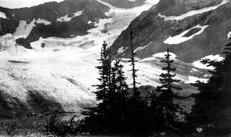
Lyman Glacier terminus.
1928, Hubbard Family Collection
Today, less than a-half-dozen ice remnants of the Snow Creek Glacier remain in the Upper Enchantment Basin. The largest segment lies on the northeast side of Dragontail Peak, where southwesterly storms deposit substantial amounts of winter snow. The ice we see now is not from one of the great ice advances of Pleistocene times, but like the Entiat Glaciers to the north, it is what remains of the more modest ice advance of the Little Ice Age. Ever since the 19th century the Snow Creek Glacier has been on a diminishing trend. Hiking across the moraines and the polished granite outcrops below Dragontail Peak, I could not help but imagine what the scene looked like 200 years earlier. The pattern of lichen growth visible today provides a general picture of the extent of ice during the maximum of the Little Ice Age. As described in the previous chapter, rock covered by ice during that period still retains the light color of fresh granite. Not enough time has elapsed to allow the dark-colored lichen to establish a dense pattern over the rock. Outcrops of granite exposed during the Little Ice Age have a noticeably darker appearance— the demarcation is quite evident. Using this color change as a guide, as much as two-thirds of the upper basin may have been ice covered 200 years ago. The south-facing slopes below Enchantment Peak were probably free of ice, as well as granite ribs separating the minor peaks eastward from the summit of Dragontail. Much of the remainder was snow and ice-covered. The lichen record suggests that the ice remnants visible today were one interconnected mass, extending through most of the length of the upper basin, ending near the present day pools and meadows north of Little Annapurna. The lakes of the upper basin, which owe their morainal outlet dams to that period of ice advance, were completely covered by the continuous ice and snow mass.
Because the exposed moraines near Aasgard Pass are so fresh geologically, vegetation is at a pioneer stage of succession. Where the soil is beginning to develop, small clumps of Cascade dryas and sedge have become established. A few small conifers are scattered throughout the piles of rock. Most are no more than a foot or two tall. Near the pass, whitebark pine seem to outnumber larch; whitebark are more suited to its dry, wind desiccated slopes. This differs from the morainal areas at the foot of Lyman Glacier, very near the Cascade Crest, where more moist conditions favor the success of larch.
For the first half-mile east of Aasgard Pass, the vegetation pattern remains much the same, except for groves of larch and small sedge meadows near several shallow, diminutive lakes. The soils in these areas are more developed than the piles of morainal rubble near Aasgard Pass and may indicate the edge of the permanent snow and ice of the Little Ice Age. The greatest change in vegetation occurs immediately below an elevation drop in the upper basin, where the main drainage pattern flows north of the lower slopes of Little Annapurna. Most of the recent moraines are left behind, as Snow Creek meanders over an area of smooth, polished granite outcrops, separated by larch groves and well established meadows.
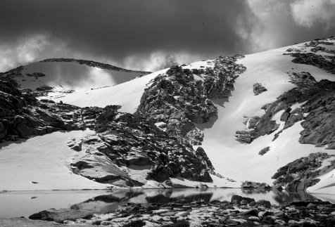
Remnants of Snow Creek Glacier.
With the next major drop in elevation (less than 300 feet), Snow Creek leaves the upper basin and flows through the four major interconnected lakes of the lower basin. At this point the larch trees change substantially in character—no longer are the trees small and wind contorted. There are groves of gnarled giants as well, some having trunks several feet in diameter. These are ancient trees and pre-date the withdrawal of the maximum of Little Ice Age glaciation. The lower basin escaped the full force of that time of glaciation, and has a complex pattern of multiaged trees and meadows with many species of sedges, grasses and shrubs. The starkness and youth of the upper basin is separated from the lower basin by only a few hundred vertical feet and a distance of less than a half-mile—surprising diversity within so limited a distance.
Chapter 5
The Chelan and Sawtooth Ranges
and North to the Pasayten Country
Few naturalists would question the observation that subapline fir is the dominant conifer throughout much of the Eastern Slope’s high country. Thriving in cold, high elevation locations and tolerating a wide range of moisture conditions, they are decidedly widespread. This ubiquitous tree is not as drought resistant as whitebark pine, but is adapted to soils that may become dry by late summer. As a species they are cold hardy, and do well in areas of deep winter snowpack; their distinctive spire shape is well suited to severe snow storms and long lasting snowpacks. Whether exploring Pass No Pass near the Cascade Crest, or hiking the eastern most summits of the Entiat Mountains, they are often the most common tree encountered. Even though whitebark pine and alpine larch may dominate specific ridges or basins, the more shade tolerant subalpine fir are rarely absent. Perceived from an esthetic and emotional point of view, subalpine fir are a predominant— an elemental—component of the high country. Their shape, color, and even their aroma, give so much substance to the character of the mountain environment. Their scent alone can trigger memories of places visited long ago, bringing back patterns of nearly forgotten experiences in unexpected detail.

Engelmann Spruce
Picea engelmannii

Subalpine Fir
Abies lasiocarpa
The role of subalpine fir not withstanding, the Cascade’s Eastern Slope has a variety of plant communities that exceeds one or two key species. Sheltered basins, even at the eastern edge of the range, often contain surprisingly moist areas, allowing mountain hemlock and Alaska yellow cedar to develop farther into the rain shadow than one might expect. Adjacent dry, warm ridges may support a combination of subalpine fir near the timberline, with Douglas fir growing slightly lower, below 6,000 feet. The diversity of habitats creates a landscape rich in contrasts.
However, from the Chelan Mountains northward there is a noticeable change in the pattern of high elevation trees: Engelmann spruce begin to appear in larger numbers in the subalpine parklands. While commonly found at mid-elevations along moist valley bottoms throughout the Eastern Slope, and frequently intermingling with subalpine fir and other trees in the high country of the Stuart and Chiwaukum Ranges [1], spruce are usually not the dominant component of the parklands south or west of the Entiat country. The transition to spruce as a principal element is pronounced in the Entiat Meadows, where its parkland is composed of large fescue meadows interspersed by groves and solitary trees of Engelmann spruce and subalpine fir.
While subalpine fir may be numerically the most common tree in the upper reaches of the Entiat Valley—where the Entiat Meadows begin—spruce seem to stand out, almost shouting their presence. Engelmann spruce are heavily limbed to the ground, their boughs thick with branchlets and heavy with pendant cones, giving a pronounced variation in shape and texture to the background mosaic of other trees. Early in the summer their cones are a reddish-purple, becoming tan in the late summer, quite noticeable against the full green of their needle foliage. The ground beneath a mature Engelmann is a dense mat of cones from the previous seasons of seed production. Its bark is composed of loose scales that easily flake off. A mature Engelmann is also dense enough to give good shelter against a storm, although its low lying, prickly branches can be bothersome. I have crawled under large spruce several times for an evening’s shelter, when even my low profile bivouac sack is a tight fit between the ground and its boughs.
Standing atop the Entiat Mountains and looking east across the Entiat Valley toward the Chelan Mountains, a ragged line of summits is barely visible beyond the highest ridges of the Chelan country. This range, the Sawtooth Mountains, is a row of high peaks less then 20 miles long, with the tallest only a few hundred feet below 9,000 feet. Its summits border the east side of 50- mile-long Lake Chelan. Much like in the nearby Entiat Meadows, Engelmann spruce have adapted to the high elevation parklands of the Sawtooth, and now thrive throughout the range.
In the Sawtooth country meadows extend to a higher elevation than in either the Entiat or Chelan Mountains. Often the summits are only 1,000 feet or less above comparatively gentle parklands. Martin Peak, Mt. Bigelow, Star and Courtney Peaks rise only slightly above the highest meadows of their south slopes. Even though their north slopes are precipitous and retain remnant glaciers (especially Star Peak), south slope routes to their summits are short scrambles from just above the highest meadows. This is one of the reasons the Sawtooth Range contains some of the finest high mountain ski touring in the Cascades— the terrain is often uniform and not especially steep, with expanses of open terrain ideal for telemark skiing.

The Lake Chelan-Sawtooth Country
One evening in late June I was hiking an easy ridge that led to the summit of Martin Peak, first winding my way between scattered larch and whitebark pine, then entering open meadows as I gained elevation. My bivouac camp was next to a spruce grove at about 7,000 feet, and I had prepared a quick evening meal before leaving for the summit. I was hoping for its early evening views of the mountains across Lake Chelan. The walk was easy enough, with meadows gradually blending into weathered granite blocks no larger than a foot or two across, and solid enough to provide predictable footing. The last few hundred feet required some easy scrambling, an appropriate level of difficulty for the lateness of the day. Even though this was a pleasant early summer evening, I pulled on my pile jacket as I reached the final few yards to the summit because of a cool breeze across the ridge-top.
From the summit rocks I could see the last of a weak storm front that still covered much of the Entiat Mountains and the upper Stehekin. Martin Peak was still in sunshine, although before long, the sun would be obscured by the wall of clouds just above the horizon. I stayed as long as time allowed, looking into the deep trough of Lake Chelan, over 7,000 feet below me. The elevation difference created a drama of space, position and time. A massive valley glacier had carved the Chelan trench a thousand feet below sea level, and two thousand feet below the level of today’s lake. Today, roughly 17,000 years after the ice began to recede, a forest has developed which extends from the lakeshore, over rocky bluffs, to just below the crest of the range. Ponderosa pine and Douglas fir cover the lower few thousand feet, subalpine fir, spruce and larch grow in the upper reaches. Tiny, dwarfed alpine plants survive near the summit of Martin Peak, adapted to the wind exposed, desiccating environment. Time, climatic cycles, and the complex, natural system that defines this part of the Cascades created what I was seeing. Although I needed to leave the summit because of approaching darkness, the images and thoughts I had while sitting there have never left me. They gave me an important insight into the character of the landscape. It was a beginning point for looking beyond the present moment when experiencing the Cascades—appreciating the ancient history of the range as well as understanding the inevitability of future changes.
In most years mid-April in the Sawtooth Range is a time of sunny and warm ski touring. The most pressing concerns are applying enough sun screen to one’s nose and ears, and avoiding the sloppiest, most unstable snow of mid-afternoon. But this year, 1996, it was a different Sawtooth Range. Temperatures were close to mid-winter averages, and fresh snowfall was powder dry and remained that way each day. Periods of snow showers were broken with extended sunshine, but the temperature remained cold above 6,000 feet. My skiing partner Rob and I planned to ascend Foggy Dew Creek, a tributary of Gold Creek and the Methow River, then cross the Sawtooth divide south of Switchback Mountain. We would ski through the headwaters of Prince Creek, and eventually traverse into the upper basin of the East Fork of Fish Creek. From this point we would cross back into the east slope of the range and ski over Fish Creek Pass into the Twisp River drainage. The route would allow us to see most of the southern half of the Sawtooth Range.
Snow on the Foggy Dew road forced us to leave our vehicle about three miles short of the summertime trailhead. In previous springs I had been able to drive to the trailhead, crashing through a few small patches of snow, but this year was different. Even though the winter had not been a heavy snow year, with only a moderate snow pack, April had been unusually cool, reducing springtime melting to a rate barely noticeable. The first few miles of skiing along the road were easy, but our pace slacked substantially after reaching the trail. The winter’s blow-down was far more than average. At times the down logs forced us to remove our skis, and then crawl over the trees and tangled limbs. Even so, traveling was not unpleasant. Old growth ponderosa pine had a fresh smell of springtime, and a firm snowpack eliminated any need to break trail. That evening we camped among a group of large, bottomland Engelmann spruce near an open stream, thus eliminating any need to melt snow for water. The weather began to appear threatening, so we used the protection of the spruce as a cook spot for our small, one burner white gas stove. Within 15 minutes snow began to fall.
We awakened in the morning to two inches of new snow and glimpses of blue sky beyond the cloud cover. The clouds appeared to be dissipating, giving us a renewed sense of optimism about the day. We began the morning’s climb through Merchant Basin among groves of large whitebark pine, dusted by a few inches of fresh snow. Intermittent patches of blue sky gave us brief views of the peaks long the Sawtooth divide. The entire scene looked and felt like late February, not mid-April. As we continued to climb higher and approached the south shoulder of Switchback Mountain, the last remaining groves of larch gave us some protection from the wind. Its strength grew as we climbed above the tree line toward the high divide, while the sky alternated quickly between clouds and openings of blue. As we traversed toward the lowest point of the divide, we cached our packs against an outcrop of granite and climbed directly to the summit, kicking steps in the wind-packed snow. From the top we caught glimpses of upper Prince Creek Basin—it looked expansive and inviting to ski, with open bowls interspersed with trees. Returning to our packs, we carefully descended the west side of the divide down a rocky, windswept ridge, finally putting on our skis and beginning a long traverse to the north. We were free of the wind, and fully enjoyed the open terrain and soft snow, now in full sun.
The Sawtooth country is full of wonderful high basin campsites, and we found one next to a small, freely flowing tributary of Prince Creek. Again, there would be no need to melt snow for water. Nearby were four large spruce, with enough space under their limbs for our tent and a cooking area. Coyote and rabbit tracks were visible all around the campsite, and as we discovered the next day, also throughout the basin, indicating a healthy snowshoe rabbit population. Apparently coyotes were responding to the available source of food—always the resourceful predator. By early evening the sky became absolutely clear, and by 9 p.m. was brilliant with stars. Even the Milky Way seemed unusually bright and distinct, as if we were camping at 10,000 rather than 7,000 feet.

Star Peak and the Sawtooth Range in early April.
The following morning we climbed through patches of whitebark pine toward the divide separating us from the North Fork of Prince Creek. From its crest we could see northward along the range to Star Peak and beyond, but to the west, summits of the Stehekin and upper Entiat country were still cloud covered, and remained so for the remainder of the trip. We descended from the lowest point of the ridge down a north-facing slope, still blanketed with 18 inches of old powder snow, interspersed with larch and subalpine fir, giving us barely enough room between the trees for an easy descent. Unlike our ascent route, which had a firm melt/freeze sun crust, this slope had been little affected by the sun’s warmth. Friction against the cold, soft snow made the skiing noticeably smooth, as if we were in slow motion.
In order to avoid a band of cliffs along the route, our traverse line required us to drop 1,500 feet, taking us from the cold, winter-like snow of 7,000 feet to spring-like conditions lower into the North Fork of Prince Creek. There the snow had been melting, leaving a well-consolidated base for easy skiing, with occasional bare patches on the more exposed south-facing slopes. The scene quickly changed as we skied to the edge of the runout zone of a large avalanche path, piled deep with snow and woody debris from a massive avalanche earlier in the winter. Pieces of shattered subalpine fir were scattered over the surface; the smell of its sap and resins was refreshing. Perhaps the sun’s warmth intensified the scent.
The 1,500 feet we lost in the morning now needed to be regained, as we climbed toward the high divide that separates the Prince Creek basin from Fish Creek and the shoulder of Star Peak. After re-entering the forest, Rob quickly found the route of the summertime trail. Even with five feet of snow, the trail formed an obvious swath through this densely forested section. As we climbed higher into parkland, we could only guess where the summer trail might be, but by then it made little difference. The semi-open country made it easy to choose any number of efficient travel routes, and as Rob remarked, “if we take a wrong turn here, we deserve it. ”
Rabbit tracks had been numerous along much of our route that day, and only a half-mile short of our evening campsite, we crossed fresh lynx tracks. At first we believed they might be tracks from a small cougar, but the spacing between hind and forefoot indicated otherwise. Also, a cougar would be out of place in the high Sawtooth country this time of year, with deer, their primary prey, wintering at much lower elevations. But it was lynx habitat. Lynx are well adapted to the soft snow, and should survive amidst the Sawtooth’s thriving rabbit population. We felt lucky to have skied across the cat’s tracks.
Camp that evening was a grove of five, large whitebark pine, with their broad, spreading limbs framing a view of Martin Peak and Switchback Mountain. We listened for the screams of a cat that night, but heard none. The evening was so quiet that turning in our down bags, sleeping pad against cold nylon, seemed noisy and out of place.

Near Fish Creek Pass–clearing skies after an April snow shower.
The next morning’s climb to the saddle overlooking Fish Creek basin was short, barely long enough for us to get into the rhythm of travel and be comfortably warm. Our descent was a steep, north slope covered with old powder snow, traversing through a stand of mature larch. Their trunks were like massive, tan colored pillars, with few branches except for the top half of each tree. The snow remained dry until we reached the floor of the basin, where we reentered spring snow conditions and a sheltered, inviting grove. Our last camp was among a group of large spruce, probably the most massive of the trip, with the majority four-and-one-half feet in diameter. Their size was remarkable, considering the tree line was only 500 feet above the elevation of camp.
There was enough time remaining in the day to climb, and then ski, several nearby slopes—more than once, it turned out. South-facing slopes had smooth, sun compacted surfaces, and northwest slopes gave us April powder, soft and consistent with just enough density for us to “feel” the snow—soft but with some substance below the surface. Traversing back toward camp, I spotted what I thought might be the major drainage from the upper basin, a slight depression in the snowpack, barely detectable across the gentle terrain. Wanting to avoid melting snow for water, if possible, I began digging with my small avalanche rescue shovel, hoping to strike the mid-point of the stream, perhaps four or five feet below the snow surface. I was lucky. One of the pleasures of ski touring in the Sawtooth is the good chance of finding running water in April, even in the highest basins. The snowpack is often shallow enough to make digging for running water worth the time and effort. On several other tours, I have been pleasantly surprised in finding short, open sections of streams.
The Pasayten Wilderness is an area of extensive parklands, U-shaped valleys and high summits, beginning 45 miles north of the Sawtooth Range. Since the early decades of the century it was considered a distinctive part of the Cascades, and in the 1930s was designated by the Forest Service as part of the North Cascades Primitive Area. [2] In many ways the Pasayten is similar to the Sawtooth country, with a pattern of high elevation meadows and relatively dry habitats, interspersed with moist, protected basins. Parklands in both areas are a mixture of Engelmann spruce and subalpine fir. Unlike the Sawtooth, which is a high backbone sub-range, closely bordered on the west by the depth of the Chelan trench and on the east by the shrub-steppe of the Methow Valley, the Pasayten is a geographically complex area, with many deep and wide valleys, and a half-dozen subranges. The region is enormous, many times larger than the Sawtooth and more diverse in its landscapes.
The western portion of the Pasayten country extends across both the east and west sides of the Cascade divide. Because a series of high ranges lie even closer to the on-coming storm fronts, the western Pasayten is not as moist as one might expect. The rugged Pickett Range offers a significant frontal blockage to storms, creating a rain shadow for the Pasayten. In the process of absorbing moisture, the Pickett Range has created its own extensive glaciation. Summers in the Pasayten can be relatively dry, with a month or more passing without a soaking rainfall. Even though the area is not as lush as passes on the Cascade Crest to the south—such as Suiattle, White or Indian Pass—Harts Pass, at the southern edge of the Pasayten, has its own characteristic high mountain meadows. July is usually the time of the richest floral display, although later in the year can be as interesting in less spectacular ways. September’s meadows are an intricate mix of textures and shades. Larch groves near Harts Pass extend west of the divide for several miles, a pattern not seen along the crest farther south. By late September the meadows have matured to a straw or golden brown hue, interspersed with either the bright green of moist sedge pockets or the bright red leaves of huckleberry patches. Larch trees have turned yellow-golden, creating a brilliant contrast to the green of spruce and subalpine fir.
Eastward from the crest, moving toward the central part of the Pasayten, the high country continues a pattern of extensive meadows and rugged peaks, bisected by deep, north and southrunning U-shaped valleys. The largest of these valleys, the Middle Fork of the Pasayten, the Lost River, and the Ashnola, are as low as 4,500 feet. Rocky summits and high parklands are 2,000 to 4,000 feet higher. Traveling further eastward, the ridges become less sharp, with the basins and open ridges gradually broadening. West of the Ashnola River lie some of the largest high elevation meadows in the Eastern Slope of the North Cascades. The gentle shoulders of Sand Ridge, Sheep and Ashnola Mountain, as well as Whistler Gulch and McCall Basin, were prized grazing areas for the sheepherders of the early 1930s. We can wander through these parklands today, using the old sheep trails when convenient, but also free to roam at will. The hiking is not difficult, even though the esthetic and intellectual rewards can be great. Depending upon how one is perceiving the landscape, it can be both simple and complex. It is simple in the scarcity of ice-covered peaks and in the apparent uniformity of its topography, but it is complex in the inter-relationship of meadow, forest and ridge-top. In either sense it is a landscape of subtle beauty.
In mid-July of 1932 Hal Sylvester traveled through part of the central Pasayten, accompanying officials of what was then called the Chelan National Forest, later renamed the Okanogan. The previous spring he had retired as Supervisor of the Wenatchee National Forest, and had not visited the area since his U.S. Geological Survey triangulation work 30 years earlier, when he had mapped much of the area. This trip was absent any formal professional responsibility for him, although he surely voiced his views to fellow foresters. Their party was on horseback and began riding toward Billy Goat Pass, a primary access to the high meadows between the Ashnola and Lost Rivers. Deer were plentiful as they continued into the Drake and Diamond Creek watersheds. Although much of Drake Creek had burned in a 60,000-acre wildfire in 1914, Sylvester noted that shrubs and young trees had made a strong recovery. Remnant snags and burned stumps from the Drake Creek fire are still evident today, when one hikes through the Three Fools Pass area.
During the 1930s Forest Service management was directed toward evaluating and maintaining the health of high mountain meadows, attempting to balance large scale sheep grazing with the long-term sustainability of the meadow plant communities. This trip was no exception, as Sylvester’s journal indicates. He may not have used terminology current today, but it is evident he believed overgrazing should be avoided. Sylvester writes in his journal: [3]
Quite a bit of rain last night, but kept snug and dry under the stretched canvas and spruce tree . . .Trail was a little slippery getting up the saddle between Diamond and E. Fork Pasayten. Swung around the head of the latter in wonderful feed area and under big round-topped mountains mostly grass covered. The areas of sheep feed . . . are large. When the sheep get onto their summer range they do not need to be shifted over very much country.

The Central Pasayten of Sylvester’s 1932 visit.
That night the weather threatened again, but Sylvester found “a sheltered place under a big spruce for a bed and stretched the canvas again.” Large spruce with their thick branching offer welcome protection from storms, summer or winter. The next day they continued down the East Fork Pasayten River to Dean Creek, and then climbed up the shoulder of Bunker Hill, a meadow-covered ridge over 7,000 feet high. Sylvester noted the area had been “overgrazed badly in previous years.” Chelan National Forest officials had closed the area to sheep grazing for the preceding several years, giving the meadows some time for recovery. He observed: “It has certainly come back nicely. It was evidently caught in time before the damage was serious.” They made camp at an old trail camp under whitebark pine and subalpine fir.
Later in the trip the group rode into the Middle Fork Pasayten River, and climbed the steep trail to a high ridge-top north of Osceola Peak, giving Sylvester a panorama he could not forget.
In the afternoon Phil, Frank and I rode to the top of Point Defiance lookout, a beautiful peak that rises 3,000’ or so from the three forks of the W. Fk.. Pasayten River. There is a good trail to the top, the upper 6/10 in burned timber, but the top 400 to 500 ft. is above timberline with many interesting and beautiful alpine plants and flowers. This lookout affords a fine view of the greater part of the upper valley of the W. Fk.. Pasayten River with a view directly up the middle Fork which is however, mostly burned out. It also affords a view of some magnificent mountain scenery.
Sylvester’s remarks about the area’s legacy of wildfire highlights another characteristic of the Pasayten: its wildfire history is unusually clear and dramatic. Especially in the central and eastern Pasayten, large wildfires have created a noticeable forest mosaic, where older, unburned stands are bordered by a patchwork of younger trees, intermingled with remnant silver snags. The younger stands, usually lodgepole pine, have a different hue and texture from the older, adjacent forest of spruce and subalpine fir. Because forest cover in the Pasayten is often continuous up to about 6,500 feet, the views from high, open ridges usually show a patchwork of species and age. Depending upon the size and intensity of each fire, either several hundred or several thousand acres burned at one time. The lodgepole forests that begin to grow several years after each fire will be composed of trees of about the same age. Lodgepole have an initial advantage in regeneration immediately after a burn, largely because their cones open only after intense heat from fire. If the stands are unaffected by large, catastrophic fires over the next 150-to-200 years, subalpine fir and Engelmann spruce will begin to replace the lodgepole, eventually creating a typical spruce-fir dominated “old” or late-successional forest of the Pasayten high country. Even though lodgepole seed-in aggressively after a fire and are dominant decades thereafter, the subalpine fir and spruce, being shade tolerant and longer lived, tend to replace the earlier forest cover.
Over the decades, enough electrical storms have passed over the Pasayten country during critical periods of drought to have ignited a number of large burns. The long drought of 1917-1931 left a legacy of fire, burning over a quarter of the present day Pasayten Wilderness lying east of the Cascade divide. The majority of the acreage burned in 11 separate fires between 1914 and 1929. [4] Most of the fire effects Sylvester saw in 1932 were little more than a decade old, and some were even younger.
In 1984 I passed through a mile or more of silver snags while hiking the Boundary Trail along the shoulder of Bauerman Ridge. The occasion helped me understand what had taken place decades earlier. Because the old forest was gone, leaving solitary snags and young lodgepole in its place, I had a nearly unobstructed view down the Chewuch Valley. The snags along the ridge and the patchwork of forest in the distance made especially clear the scale of wildfire in the Pasayten, a pattern of drought and lightning combining to create change. [5]

Chapter 6
A Journey in 1870:
A Grand Circle Through the Cascades
Travel by Europeans into the Eastern Slope of the North Cascades was rare until the latter half of the 19th century. Lewis and Clark’s 1804-1806 expedition passed far to the south of the region, although David Thompson of the Canadian North West Company came within view of this mountainous area in July of 1811, when he canoed from the upper Columbia to its mouth. Thompson encountered local tribes as he passed the Methow and Wenatchee Rivers, making what most historians consider the first European contact with native groups using the Eastern Slope for hunting and gathering. [1] As was his custom, he stopped to parlay with the Methow tribe, smoking the pipe and watching a dance performed for his benefit. He did much the same with the Wenatchee tribe, noting that they appeared to be a large tribe, apparently healthy and prosperous. Thompson took special note of their handsome goat hair blankets, a result of hunting in the nearby mountains, where deer, mountain goat, and mountain sheep were available.
Thompson’s 1811 canoe paddle of the Columbia was only part of his combined four-year reconnaissance surveys (1807- 1811), when he sought to establish the Northwest’s potential for fur trading. Although Thompson visited much of the Columbia River from its mouth to its upper reaches in the Canadian Rockies—some of it in great detail—he paddled swiftly by the Cascade Eastern Slope, and did not venture toward the heart of the mountains. [2]
The first European to do so may have been Alexander Ross, whose journeys from 1811-1816 included a crossing of the Cascades from east to west, beginning in the Methow Valley and reaching the upper Skagit Valley. Like Thompson, Ross was working for the North West Company, hoping to find a trade route for furs to the Puget Sound region from Fort Okanogan, a North West Company outpost. In the summer of 1814 he traveled up the Methow Valley, crossing the Cascade divide somewhere north of Lake Chelan. Some uncertainty exists as to which pass Ross traveled. Some historians have assumed he used what is now called Cascade Pass, but this view is not universally accepted. [3] Ross’ journal does indicate he traveled some distance west of the Cascade divide before retracing his route.
Regardless of which pass Ross may have used, his journey should be considered pivotal, the first documented crossing of the North Cascades by a European. Ross’ party encountered rugged topography, dense vegetation and a host of unknown variables. Anyone who has traveled through trail-less areas in the North Cascades can appreciate the difficulties of terrain and complexity of route that any party would face. Although Ross was helped by native guides, the route could not have been easy. The difficult stream crossings, alder and vine maple thickets, cliff bands, and all the rest of the wild Cascades must have constantly impeded progress. In addition to the challenge of the natural environment, they were limited by the nature of early 19th century technology. Today’s mountaineers would view their clothing, food, packs, boots and other equipment as burdensome and inadequate. Sometimes I believe this comparison may be weighted too heavily in favor of the superiority of contemporary styles of mountain travel. Nineteenth century adventurers like Ross and Thompson lived a life with fewer and simpler needs, and were perhaps less troubled by frequent experiences of physical discomfort—the wet, cold and fatigue of wilderness travel.
A second phase of travel into the Eastern Slope of the North Cascades was not motivated by furs, but by the desire to find feasible routes for wagon roads, and a decade later, railroads. [4] In 1860 E.F. Cady and E.C. Ferguson traveled by horse and mule from the Snohomish and Skykomish valleys on the west side of the Cascade divide, into the upper Wenatchee drainage on the Eastern Slope. They used a low pass, now called Cady Pass, that had been a common Native American travel route. Even though Cady and Ferguson were able to travel as far as the Lake Wenatchee area, they shortly abandoned as impractical their goal of a freight road over Cady Pass. There is some indication that the Cady Pass route had been used by some of the earliest European fur traders in the Northwest. In August of 1887, A.B. Rodgers discovered old axe marks at several locations near Lake Wenatchee and in the Little Wenatchee drainage below Cady Pass, while searching for a route for Jim Hill’s Great Northern Railway. He judged the “old cuttings probably 50 years old and the work of the Hudson’s Bay men.” [5] Sylvester made a similar entry in his notes over 30 years later, describing old blazes he had seen along the Little Wenatchee below Cady Pass. Sylvester followed the blazed route, cutting out grown-over blazes and counting the annular rings covering the original marks. He was convinced they were from the era of Hudson Bay trappers and traders. [6]
By the late 1860s pressure was building to find a suitable route for a Puget Sound terminus of the Northern Pacific Railroad, chartered in 1864 to provide transcontinental rail service from the Midwest to the Pacific. The Northern Pacific sent its assistant chief engineer, Daniel C. Linsley, to find a route across the northern portion of the Cascade Range. While the routes Linsley explored were never used by the Northern Pacific (both the Columbia River and Stampede Pass routes to the south could be more easily constructed), his journey of 1870 gives us a detailed description of the Eastern and Western Slopes of the North Cascades, as well as impressions of his Sauk and Skagit Indian guides. Linsley’s two crossings of the Cascade divide were the first by a non-native between Ross’ route to the north and Cady’s to the south. Surprisingly, it was not until the 1970s that knowledge of his travels became common among Northwest historians. His journal was re-discovered among Northern Pacific Railroad Company records by the staff of the Minnesota Historical Society, and later published by H.M. Majors in the journal “Northwest Discovery”.

Linsley’s 1870 Trek Through the Cascade Range
The strategy for Linsley’s investigation was developed by the Northern Pacific’s Chief Engineer, Edwin F. Johnson, based upon the preliminary findings of an 1867 Northern Pacific exploratory team lead by James Tilton and A.J Treadway. They had traveled a considerable distance up the Skagit and Sauk Valleys, gathering as much information as possible from Native Americans: travel routes, general topography, and the patterns of major watersheds both west and east of the Cascade divide.
Linsley was directed to begin his search north of latitude 48 degrees by investigating as thoroughly as possible the two largest southern tributaries of the Skagit: the Suiattle and Sauk Rivers. He hoped they might lead to a feasible route into either the head of Lake Chelan or the Lake Wenatchee area. However, Chief Engineer Johnson was pessimistic of a satisfactory route through the Stehekin Valley, learning shortly before Linsley’s departure that the descent from the Cascade divide was discouragingly steep. He also had reports that the Lake Chelan area was probably too rocky and steep for a feasible railroad route. Even so, he was intrigued by other reports mentioning a pass somewhere in the upper Suiattle that might be lower than passes to the south. Learning more about this pass was a major objective of Linsley’s trek through the North Cascades. After a thorough study of all possible northern routes, Linsley was then to travel south and investigate Snoqualmie Pass and other possible crossings in the upper Yakima watershed.
At the end of May 1870, Linsley began canoeing up the Skagit River with a small party that included six Skagit Indians, essential for the success of the expedition as guides and canoeists. Skagit tribal members had cautioned him that the only possible route to Lake Chelan, south of Cascade Pass, was to travel up the Suiatl (Suiattle) River, then up Kaiwhat (Sulfur) Creek, crossing Kaiwhat Pass, and finally down a major drainage (Spruce and Agnes Creeks) to the Stehekin Valley. The Skagits disclosed that several generations earlier, in the early 1800s, the route was heavily traveled and easy to follow. From the Stehekin Valley the trail crossed over Twisp Pass into the Methow country, eventually leading to the Okanogan Valley. Native traders had been carrying their furs to Fort Okanogan (established in 1811), but the route had been largely abandoned when trading forts were established in the Puget Sound region. Both the Skagits and Sauks mentioned a second pass, considered a much easier crossing. It lay to the south and today is called Indian Pass. This deeply green, park-like pass is near the headwaters of the Sauk River and leads directly to Lake Wenatchee and the Wenatchee River system. Later in the summer, Linsley, using this route, traveled the entire distance of the Wenatchee River down to the Columbia, then up the river to Lake Chelan. He continued up lake and hiked into the Stehekin Valley, Agnes and Spruce Creeks, eventually revisiting Kaiwhat Pass. It was an impressive, great circle through the Cascade Range.
By early June Linsley’s party arrived at the mouth of the Sauk River, a main tributary of the Skagit, and continued until a second river, the Suiattle, joined the Sauk. At this point Linsley proceeded with only a portion of his party, which included John Tennant, his assistant and interpreter from Bellingham, and four Skagit Indians. After canoeing as far as possible, they cached all unnecessary equipment and began traveling by foot, reaching the mouth of Kaiwhat (Sulphur) Creek around noon on the 5th of June. Early June in this part of the Cascades is not yet summer; snow often remains in shaded areas of even midelevation valleys, like Sulfur Creek. At higher elevations much of the winter snowpack is melting rapidly, creating swollen streams with difficult and sometimes dangerous crossings. Linsley also discovered that the moist climate and mild growing conditions west of the Cascade divide could transform, in only a few decades, what was once a broad, heavily used trail into a maze of brush and fallen trees.
The journey up Sulphur Creek toward the Cascade divide took Linsley through some of the most dramatic country in the North Cascades. This is an area of high summits, massive glaciers and deep, green valleys. The topographic relief is often extreme. Linsley was impressed with what he saw: [7]
From the north bank of the creek the snow peaks rise almost perpendicularly. Any number of little rivulets creep out from under the enormous snowbanks and tumble down the rocky sides of the mountains. I noticed one which I estimated falls a thousand feet in a nearly perpendicular descent. The timber on the Kaiwhat is the best I have seen. The cedar particularly is most remarkable . . . After a fatiguing days march . . . over rocky spurs and through tangled woods we camped.
His description of traveling along Sulfur Creek is not exaggerated. I once descended from the shoulder of Dome Peak into Sulfur Creek, and struggled through a tangle of fallen trees and brush along the valley bottom. If anything, Linsley minimized the difficulty of travel, if not the grandeur of the place. Even though it was hot, humid and buggy, the setting of Dome Peak and the surrounding country—the rock walls, glaciers, steep green slopes and the deep valley of Sulfur Creek—made an indelible impression on me.
On June 6th Linsley’s group continued up Sulphur Creek through alder thickets, windfall and more giant conifers, many over six feet in diameter. By afternoon they were below a major mountain, and well positioned to reach their goal of Kaiwhat Pass the next day. From his description, I assume he was looking at the granite mass of Dome Peak, one of the North Cascades’ most imposing mountains.
The side hills are exceedingly bold and precipitous and appear to be a solid mass of granite . . . At 3 p.m. I saw two Cinnamon or Brown bears quietly feeding in plain view and not more than 300 feet distant . . . Just at this point we reached the snow. At 4 p.m. we camped on the edge of a snowbank at the foot of a very steep ridge just in front of us which the Indians tell us is the Pass. [8]

Kaiwhat Pass, with Dome and Sinister Peaks beneath a mist.
The next morning, June 7th, they left camp at 4:30 and began the ascent toward the pass, hoping to peer into Spruce Creek. Its water flows toward the east, first joining Agnes Creek and then the Stehekin River, eventually running into Lake Chelan. The distance to the pass was not great, estimated by Linsley to be no more than two miles, but it was steep and difficult traveling. By 7 a.m. they arrived at the divide. Although the pass is a spectacular place, Linsley could see little beyond the confluence of Spruce and Agnes Creeks. The shoulder of Agnes Peak blocks the lower Agnes and Stehekin Valley, so those views would have to await the latter part of his great circle at the end of July.
The view from the summit [Kaiwhat Pass] is very fine . . . The snow we found about six feet deep and very soft in the bright sun . . . The elevation of the pass is 6,135 ft. above Tide. The old Indian trail passed through at its lowest point. A deep valley [Spruce Creek] leading Northeasterly heads at a point directly opposite the source of Kaiwhat Creek.
Linsley was not optimistic about this pass for a railroad route, realizing the only practical passage would be by means of a tunnel at least a mile and one-quarter in length. Before returning to camp, he noted the “red snow found only at great elevation.” This algae is found throughout the permanent snowfields of the Cascades, sometimes turning a brilliant red by mid-summer. Linsley also noticed the grouse-like ptarmigan and pink heather, which he termed Scottish heather, two of the Cascade’s most ubiquitous inhabitants. After taking a few measurements with his barometer and thermometer, Linsley began his descent to camp.
At 10 o’clock we commenced our return. The sun had so much softened the snow that our feet sank deep at every step and at places the traveling was not merely difficult but dangerous from the liability of the snow to slide in large masses. One such slide occurred on the opposite side of the ridge we were traveling on. Of course we could not see it, but it was evidently no slight affair as it sounded like heavy thunder and continued for some two minutes.
In coming down I practiced the plan pursued by Indians, to wit, sitting down upon the snow and allowing the force of gravity to take me down, using a stout stick as a break (sic) to regulate the speed. It may not have been, and indeed I am convinced it is not the most dignified mode of traveling known, but it was an eminently successful one in my case.
Linsley’s description of his quick descent is nearly identical to the sitting glissade, so often used by contemporary mountaineers, except his stick has been replaced by the more versatile ice axe. The large amount of snow Linsley encountered matches the time of year, the middle of June, when the high country has not yet lost the previous winter’s snowpack. It is also relevant to remember that in 1870 the Cascades had only recently left the cool and snowy Little Ice Age, so a high country covered with snow in early summer would not be exceptional.
Linsley’s party left the Suiattle drainage after this adventure, and turned their attention to moving up the Sauk. They hoped to cross what is now called Indian Pass, which his Native American guides correctly considered an easier route than Kaiwhat. On June 18th Linsley, 11 Indians and his assistant John Tennent, left the lower Sauk in three heavily laden canoes. By June 20th they had arrived at the upper reaches of the north fork of the Sauk, only a few miles from Indian Pass. Linsley found the topography nearly as rugged as the Kaiwhat country, with narrow canyons, steep side slopes and peaks rising abruptly above the canyons. The party also experienced inclement weather, so typical of the Cascade Crest, an abrupt contrast to the hot, dry period Linsley experienced while in the Kaiwhat country.
Thursday, June 30th. We passed an uncomfortable night from the rain and cold. The rain commenced falling just as we reached camp last night and continued several hours . . . Left camp at seven o’clock . . . At a distance of about two miles we came to the snow line.
They continued another four miles, reaching the upper portion of the valley at about 3,700 feet. After climbing along a steep ridge they traversed into Indian Pass. Linsley’s altimeter indicated 5,042 feet. The pass shelters several meadow areas where the snow depth was estimated at seven feet. From marking on adjacent trees Linsley estimated the maximum winter snow depth to be 20 feet or more. [9] To today’s mountain travelers his estimate might seem inflated, until Linsley’s proximity to the end of the Little Ice Age is considered.
There was more at Indian Pass to interest Linsley’s party than estimating the extent of the winter snowpack. They found an opportunity to augment their shrinking food supplies.
Seeing a mountain goat or sheep high up on a neighboring snow peak I dispatched two Indians to endeavor to get it to add to our stock of rations which are rapidly diminishing and in relation to which I am somewhat anxious . . . About dusk the hunters returned having captured their game. It was a male and the Indians say a large one.
Friday, July 1st. Dined on goat steak which although tough, was very sweet and well flavored. A fat grouse known here as the blue grouse furnished me an excellent supper . . . Flies and mosquitoes are abundant. A hummingbird paid us a visit this afternoon and spent some time about the trees under which we are camped. It is certainly odd for a Yankee to find these forms of animal life where the snow is lying 7 feet deep on the ground.
Needing a high point to give them some sense of both the near and far topography, the following day Linsley and Tennant climbed to the summit of the prominent peak to the north, today known as Indian Head.
The day was perfectly clear . . . The view was very fine in every direction and we were able to get a very good idea of the surrounding country.
Although Indian Head is less than 8,000 feet tall, its location directly south of Glacier Peak and the remote Tenpeak Range, together with continuous meadows radiating from below its summit, create a striking setting. Indian Head’s south side is an easy ascent through open meadow slopes to its summit rocks; the north side is precipitous with small remnant glaciers. Because Glacier Peak so dominates the view to the north, it is surprising Linsley did not include a clear mention of the mountain in his summit journal entry.
Over the next few days Linsley and Tenant studied possible routes both north and south of Indian Pass, hiking through the high meadow country where a section of the Pacific Crest National Scenic Trail is now located. This portion of the Cascade divide, north from Indian Pass to White Pass, and south from Indian Pass to Cady Pass, includes one of the more notable meadow and parkland areas of the North Cascades. There are larger meadows in the Pasayten and more thickly flowered areas near Mt. Rainier, but nowhere else in this mountain range have I seen a greater richness of color and texture—it is quintessential Cascade meadow country. Part of its character comes from the area’s backdrop of Glacier Peak and the White River Glacier. Both are imposing, yet distant enough to avoid overwhelming the subtleties of the closer view. The meadow country extends to the south and also eastward across several high ridges; nearby Wenatchee Ridge and East Cady Ridge are Eastern Slope meadow walks that offer interest and beauty even when rain-soaked, or simply shrouded in clouds.

Near White Pass, looking toward the White River Glacier.
The view from Indian Head is most engaging when the sun is low in the west; the valleys seem deeper and darker green than at other times. Transitions in texture, shape and color emerge between the elements of this environment, from the rock and ice of the highest peaks, through the high basins and parklands, eventually ending in forested valleys. Seeing this landscape is absorbing in itself, but using our other senses adds complexity: the muted sounds of streams cascading in the distance and the rhythmic cadence of breezes blowing against nearby fir boughs. Lower on the mountain the scent of firs can be intense.
After considering alternate routes to the south, Linsley, Tennant and their guides began their trek down the White River, a long and deeply incised valley north of Indian Head, draining to the east toward Lake Wenatchee. Although much of the lower valley is densely forested with old growth conifers, at numerous points along the route the forest opens, disclosing Indian Head, remote Amber Creek Basin, and the summits above Thunder and Lightning Creeks. Mile-long Fifth of July Meadows—in recent decades more brush than meadow—extends below Clark Mountain’s abrupt south flank. Only 30 years after Linsley passed beneath Clark Mountain, sheepherders began using its meadow-rich upper basins.
After three days travel the party arrived at Lake Wenatchee, described by Linsley as “a beautiful sheet of water.” Continuing down the Wenatchee River the party split, with Tennant traveling through the Chumstick Valley (the eventual route of James J. Hill’s Great Northern Railroad decades later), and Linsley following the “Great Canyon of the Wenatchee,” known today as the Tumwater Canyon. The two groups joined for a combined camp near the present community of Leavenworth. Linsley found the journey down the Tumwater spectacular, although not as difficult as his guides had warned. The canyon appeared “rather crooked and walled in by mountains of rock from one to five thousand feet high . . . the upper portions of these mountains are precipitous masses of rock.” Linsley was not exaggerating the area’s rugged character. It is much the same today, with the addition of an all-season highway paralleling the river. During August, 1994, the canyon and its high ridges were swept by a massive, lightning-caused wildfire, burning portions of the forest cover, leaving a mosaic of green trees and silvered snags. In many respects the Tumwater is more dramatic and interesting than before the fire, with cliffs and narrow, rocky gullies more visible. Big leaf and vine maple grow more vigorously now, with less competition from conifers. Their yellow, orange and red leaves of autumn are striking against a pattern of green conifers, rock and silver snags.
Linsley and Tenant’s camp was near a Native American fishing site:
Here [the mouth of the Tumwater Canyon] the salmon collect in great quantities and hither every year come swarms of Indians to lay in their year’s stock of food. Some two or three hundred are now camped along here all busy as a swarm of bees [July 10th].
The following day Linsley’s party rode on horseback toward the confluence of the Wenatchee and Columbia Rivers, where a small trading post had recently been established. The first few miles were among open stands of ponderosa pine, with the right density “to shelter the grass from the fierce midsummer sun. There was no underbrush and one might drive a lady’s carriage with comfort in almost any direction.” [10] He considered the nearby grassland the best grazing land seen thus far on his trip. Before reaching the Columbia the pine stands completely disappeared, with the lower Wenatchee Valley turning into a shrubgrassland, except for tall cottonwoods near the river’s edge.
After several days near the confluence re-supplying and resting the party, Linsley was prepared to continue his journey toward Lake Chelan, the Stehekin Valley and eventually Kaiwhat Pass. He borrowed a canoe from Jack Ingram, the proprietor of the trading post, and began the paddle up the Columbia with Tennant and two remaining Sauk guides. Evidently he preferred to take his two trusted Sauks, rather than arrange for the local Wenatchi Indians to act as guides. Linsley had considerable respect for his Sauk guides, placing great trust in them, and considered them outstanding “campers and packers and the most superb boatmen he had ever seen.”
Paddling up the Columbia was not easy, working against a substantial current and hot July weather. The Columbia of 1870 was a living, naturally flowing river, with rapids, including the Entiat Rapid, one of the party’s several challenges. After less then two full days they were able to reach the small river flowing from Lake Chelan, and began the three-mile portage and 350 foot climb to the lake. Following the morning’s portage they began moving up lake, with Linsley and Tennant on foot and their guides paddling the canoe. They quickly realized the canoe was too small and too leaky for their needs. Even after earnest negotiation, Linsley was unable to obtain any other canoes from the local Chelan Indians. They had little choice but continue as best they could, hoping to find canoes from groups camping further up Lake Chelan. Linsley and Tennant continued walking much of the distance along the shore that afternoon, making their first night’s camp about 10 miles from the mouth of the lake.
After paddling part of the next morning they approached an encampment of about 20 Chelan Indians, bound for the head of the lake to gather service berries. To his relief Linsley was able to obtain a second canoe, in addition to two Chelans as guides. The second canoe was indeed essential; beyond this point the shoreline became much steeper and, in places, nearly impossible to hike. His observations of the upper lake’s steep and rocky shoreline clearly verified the reports Chief Engineer Johnson had received earlier, about the difficulty of a rail route along the lake.
Typical of Lake Chelan weather, high winds developed and delayed their progress, at one point forcing a layover of several days. The lake has several long and wind exposed sections where dangerous waves can develop rapidly, an especially serious threat for open canoes. Finally, on the afternoon of July 19th, they reached the head of the lake and entered what Linsley called the Chelan River, known today as the Stehekin. They poled upstream for nearly seven miles before making camp, continuing the next day to the limit of canoe travel, just short of the confluence of Agnes Creek and the Stehekin River. A series of white water gorges in both streams made further canoe travel impossible. At this point Linsley separated his party, sending Tennant up the northern fork (the main Stehekin River), even though he realized the probability of finding a suitable rail route was low. It is understandable that Linsley would be pessimistic. Standing near the confluence, the topography of the upper Stehekin Valley is notably rugged and steep, with the ridge tops rising as much as 7,000 feet above the valley floor. Nevertheless, the route needed to be fully investigated. Linsley knew the upper Stehekin led to a pass (Cascade Pass), which the Skagit Indians used in crossing to the Eastern Slope of the Cascades.

Lower Stehekin River, 1890s
Wenatchee Valley Museum and Cultural Center Photo
Linsley and two remaining native guides traveled up the other fork of the Stehekin drainage, the broad and more promising appearing Agnes Creek Valley. There was some urgency in their timetable, since food supplies would be adequate for only another week. After traveling six miles they reached a break in the forest where they could look westward into the West Fork of Agnes Creek. Fortunately, Linsley chose to continue further up the main Agnes Valley, rather than explore what would have been a spectacular, but fruitless lead. The West Fork ends in an immense cirque formed where the Chickamin and Dana Glaciers descend from Dome Peak and Spire Point. The topography of the West Fork is severe, with steep, high rock buttresses, massive glaciers, and waterfalls plunging hundreds of feet. It is hard to imagine a 19th century rail route finding any success there.
Linsley continued up the Agnes drainage until he reached a second tributary, descending from Kaiwhat Pass, today called Spruce Creek. The valley is about six miles long and required hiking through dense brush, across fallen trees and challenging streams, all so typical of this part of the Cascades. Worse yet, the weather had become unpleasantly wet and cold, very different from the hot weather of his western approach to the pass in early June.
. . . our progress was discouragingly slow. Friday, July 22. The rain of yesterday continued through the night and show no signs of abatement this morning . . . Our route up lay along the foot of the mountain some distance from it to avoid the dense alder thickets . . . small brooks tumble down the precipitous mountain sides from the immense snow fields and glaciers that cover the peaks on each side of the Pass.
Linsley spent little time at the summit—they were wet and cold. The contrast with their pleasant visit six weeks earlier was extreme, but not out of character for the changeable conditions along the crest of the Cascades.
At half past twelve o’clock we started on our return. The rain which had been slowly falling during the last twenty-four hours now came down in earnest and our progress down the valley through the dense thickets and wind-falls and over burnt tracts was slow and scarcely less laborious than the ascent . . . At about four o’clock the rain ceased and the sun came out for a few moments to our great satisfaction.
The next day they retraced their route back to the mouth of Agnes Creek and found a note left by Tennant, informing Linsley the search to the north had been fruitless. The topography was wholly impractical for rail line construction. Even though Linsley’s route was perhaps less discouraging, it also was to remain a wilderness.
Linsley had completed an epic North Cascade journey, passing through some of the Cascade’s most grand country. The trip had been strenuous—Linsley lost 26 pounds of body weight between late May and his return to Seattle in early August. Both Spruce and Sulphur Creeks have remained two of the wildest areas of the range. The dense brush, steep slopes, windfall and rushing streams are as much a challenge today as in his time.
Kaiwhat Pass—August 1996
After nearly two days travel through the Agnes Creek Valley and along the shoulder of Saddle Bow Mountain, my friend Rob and I made camp within view of Ross and Kaiwhat Passes. The trip had begun at High Bridge in the lower Stekekin Valley’s ponderosa pine and Douglas fir forest. July and early August had been warm and dry, so by mid-August the grasses under the forest canopy were dried and straw colored. The trail was dusty from the fine textured soil. But within three miles the forest began to change as the trail passed through a section of massive red cedar and Douglas fir. As we gained elevation and traveled westward toward the crest, Ceanothus brush gave way to bunchberry and twinflower in response to the progressively more moist habitat. Starting as we had near the edge of the Eastern Slope, and continuing to Kaiwhat Pass on the Cascade divide, we would see the full range of Cascade Eastern Slope landscape.
The present day trail along the lower Agnes Valley is far enough from the Agnes Gorge to nearly hide its spectacle. But occasionally, Rob and I could see where the stream had cut nearly perpendicular walls. It is perhaps understandable why Linsley did not mention the lower gorge in his journal, because the easiest traveling is generally some distance from the creek. But about six miles from High Bridge, just upstream of the confluence of the West and South Forks of Agnes Creek, the trail climbs high above the edge of the upper gorge along a cliff-like overlook. The sight of that chasm has no doubt impressed passers-by for centuries. Because the topography above the confluence so restricts the parameters of a natural traveling route, Native American traders are likely to have hiked nearly this identical route. Linsley was impressed by its perpendicular walls, and so noted in his journal.
Our first camp was at the junction of Spruce and Agnes Creek beneath a stand of large hemlock and red cedar. I was surprised Linsley did not mention the large conifers growing along the valley bottom. Even though they may not, on average, equal the size of trees in Sulphur Creek, his journal entries concerning the forests along the Agnes seem substantially understated. Several of the Douglas fir and red cedar groves are of impressive size, with member trees of imposing girth and age. Perhaps the cold and rainy weather he endured in Agnes Creek gives a partial explanation, affecting his attitude and overall feelings about the area. His energy and interest may have been waning after several months of challenging travel and inadequate rations, at least his zeal for journal entries.
By mid-morning of the third day we reached Ross Pass, the beginning of several hours of rewarding hiking across untouched parkland, as we approached Kaiwhat. Linsley had not reached Kaiwhat Pass by way of Ross Pass, but had used the more direct valley bottom route where the historic Native American crossing lay. Our route was more circuitous, but avoided alder thickets, and included several high points from where we could see all of the Agnes and Spruce Creek watersheds. It was a time of intense bloom at Kaiwhat Pass, with lupine, bistort and pink heather near their climax; their colors were more intense because of the overcast sky. Droplets of moisture from the morning’s brief showers had saturated everything—a characteristic North Cascade setting, but without the cold, drenching wet Linsley had experienced.
We hiked into the saddle of Kaiwhat Pass by early afternoon. In several ways the scene had changed since Linsely’s visit. Because he had stood at the pass 125 years nearer the Little Ice Age, he saw more ice on Sinister and Dome. As might be expected, all traces of the old travel route had disappeared. Several groves of mountain hemlock in the pass included trees of considerable age, and would have been large even in 1870. If Linsley had chopped any blazes on the trees, they were grown over long ago. The most visible signs of activity were bear and coyote scat. Even with clouds scudding by and only occasional glimpses of the summits, the setting beneath Dome and Sinister is imposing. Linsely could not have chosen a more dramatic location for his northern-most crossing of the Cascades.
Chapter 7
Glacier Peak and Ice Creek Ridge: 1906
By 1906—little over 30 years after Linsley’s summer-long adventure in the Cascades—travel through the high country by sheepherders, miners and adventurers had become nearly routine. The high country of the Cascades had been transformed into the domain of the expanding American culture. No longer was it an unknown mountain range, so remote that Indian guides were considered essential for way-finding. A mountain traveler could expect to meet other people along travel routes, unless the itinerary was unusual, or directed toward the most remote country. Even so, the Cascade Range was wild enough and filled with enough uncertainties, to make a search for high adventure an easy charge. The mountains themselves had lost none of their ruggedness, nor had cross-country travel become less challenging.
In 1906 C.E. Rusk and A.L. Cool planned a grand summertime adventure, beginning and ending at Domke Lake near Lake Chelan. Their objective was to climb to the summit of Glacier Peak, approaching the mountain by way of Railroad Creek, Cloudy Pass, and a long descent to the floor of the Suiattle Valley. From there they would ascend Glacier Peak’s unclimbed eastern flank. Their return would be by way of Buck Creek Pass, Phelps Creek, and a high traverse of Ice Creek Ridge into Ice Lakes, finally descending into the upper Entiat Valley. From the Entiat River, Rusk and Cool would climb over Milham Pass into Emerald Park, not far above Domke Lake. All of this, with the exception of the climb of the mountain itself, was done leading
Cool’s two sure-footed pack horses. Their crossing of Ice Creek Ridge was extraordinary, using a route most backcountry horsemen today would consider far too difficult to even consider. Cool was a trapper, hunting and fishing guide, and occasional prospector. His base was a homestead at Domke Lake where he had a comfortable cabin and fishing camp. [1] He arrived in the Lake Chelan country in the mid-1890s, leaving behind a life as a university trained employee of the Great Northern Railroad. Cool chose a remote and primitive way of life, before long becoming fully adapted to his mountain environment. His winter trap lines began above Domke Lake, in the Emerald Park area of the Chelan Mountains, and extended into the upper Entiat Valley, where he had built a second, smaller cabin. The upper Entiat was a long snowshoe trek over Milham Pass from Emerald Park, a route Cool traveled alone for decades while checking his trap line. His skill as a mountaineer, as well as his rugged constitution and independent lifestyle, made him an ideal companion for Rusk. Fortunately for their upcoming adventure, Cool was also the owner of two superb mountain horses, Benny and Johnny. Cool’s understanding of his animal’s strengths and limitations, and his detailed knowledge of a feasible route across Ice Creek Ridge, made the traverse possible.
C.E. Rusk was a Portland attorney and pioneering mountaineer of the Northwest, leading extensive explorations of the slopes of Mt. Adams, including the first ascent of the Castle route. Cool and Rusk’s climb of Glacier Peak was the mountain’s second ascent. [2] In 1910 Rusk led a well organized attempt to climb Mt. McKinley by way of the Ruth Glacier, with Cool as a key team member. [3] Rusk’s well written Tales of a Western Mountaineer is a fascinating account of the early days of Northwest mountaineering, and included a chapter about the Glacier Peak climb. Rusk wrote a second account of the trip for the Chelan newspaper, including four of Cool’s black and white photos.

A. L. Cool, lounging in his hunting camp.
1910, Jean Renfro Family Collection
According to Rusk’s account in his book [4], their 1906 trip came largely from Cool’s invitation to join him for the adventurous climb, although he had seen the peak from Cloudy Pass in the summer of 1904, and earlier from the summit of Mt. Baker. He had hoped to climb it in 1905, but his plans were “temporarily suspended” for an ascent of Mt. Rainier. [5] Rusk was intrigued by the mountain’s remoteness and beauty. In late August he disembarked at the mouth of Railroad Creek from the Lake Chelan steamer “Lady of the Lake”, the first in a series of “Ladies” that over the decades have traveled the lake. After dinner at Mrs. Schearer’s small hotel and eating house, he was greeted by Cool, and shortly afterwards met Cool’s two experienced and mountain- wise pack horses, Benny and Johnny. Cool had made all the arrangements for their trip, including camping equipment and food. All Rusk needed to bring was his personal equipment, including his alpenstock, the progenitor of the modern ice axe. Cool used a home-built ice climbing tool, fabricated from an ice pick and solid piece of hardwood, approximating the size of modern ice axes.
They were on their way that first afternoon, traveling some distance up Railroad Creek before camping under a canopy of large trees, described by Rusk like being in the midst of a “ghost forest”. [6] Whether Rusk was referring to burned snags surrounding a grove of live trees is open to some speculation. In the late 19th century prospectors intentionally burned much of Railroad Creek to aid in finding mineralized deposits. As odd (or shocking) as it may seem to us, burning off the cover of forest and brush was a common practice by miners of the era. The scene is quite different today. The Railroad Creek Valley has changed over the past 100 years, with the re-growth of a nearly continuous forest cover.
From their campsite a mile beyond the Holden Mine, the scale of the surrounding peaks was evident: “...the pinnacles of Copper Mountain and its attendants shoot into the sky, while on the north loom the domes and spires of Bonanza, flanked by two great glaciers from which a series of waterfalls and cascades plunge into the canyon of the larger stream”. [7] The following morning they continued past what was then called Roger’s Lake (now Hart Lake), and found its setting directly beneath Bonanza Peak picturesque and dramatic. Rusk’s description is no exaggeration. Whether in August, with waterfalls flowing off Bonanza’s massive rock faces from its melting ice, or in March, when huge mounds of avalanche debris reach across the valley, the place can evoke strong feelings.

Rusk and Cool’s Epic Journey of 1906
Cool had planned their journey to progress in easy stages. The second day’s travel ended at North Star Park, the name Cool used for the expansive meadow area below Cloudy Pass. Cool’s campsite was above timberline in the green parkland directly below the south summit of North Star, which is now called Cloudy Peak. Their two horses had plentiful feed in the meadows surrounding camp. The nearby summit of Cloudy is an easy scramble, and gives one an exceptional look at the total landscape, including an extended view down Agnes Creek toward the peaks of the upper Stehekin. To the south of their camp an arc of summits from Dumbell to Chiwawa Mountain framed the ice mass of Lyman Glacier (old photos show a much larger ice mass than exits today). Below the glacier was turquoise colored Lyman Lake, called Glacier Lake in Cool’s time. “North Star Park...overlooks the great Lyman Glacier, the extreme head of Railroad Creek, and slopes gently down from Cloudy Pass to Glacier Lake, dotted here and there by rare alpine trees and carpeted with green grass and flowers.” [8] Very late that night, a short time before first light, their sleep was broken by the piercing sounds of coyotes, startling Rusk for a moment until he realized the source of the chorus.
Before packing up the next day they hiked to a ridge-top south of Cloudy Pass, where a low segment of the Cascade Crest lies 2,000 feet below the west shoulder of Chiwawa Mountain. There they enjoyed their first full view of Glacier Peak. The deep valley of the Suiattle lay five miles to the southwest, visible as a green abyss between their vantage point and the ice-covered summit. As they left the ridge-top the pair spotted some wary and surefooted residents. Three mountain goats noticed them and quickly escaped by running along the ridgeline toward Chiwawa Mountain. In no more than five minutes the goats climbed a considerable distance up the peak by way of a steep wall, showing little apparent effort.
By mid-morning Cool and Rusk were packed and headed across Cloudy Pass, finding their way to Suiattle Pass along an interconnecting ridge. A group of miners were working a claim just south of the pass and invited them to a mid-day meal, a stew consisting largely of mutton. Continuing by mid-afternoon, they traveled through several major drainages, and by evening were not many miles from Buck Creek Pass, entering beautiful subalpine parkland. Rusk noted with some displeasure, how sheep grazing detracted somewhat from the nearly ideal setting. The area near Buck Pass is indeed scenic, made especially so by the nearness of Glacier Peak and the glaciers of the upper Suiattle. Sylvester considered it “the most beautiful place in the Cascade Mountains”, a considerable statement coming from someone so well traveled in the high country. [9]
That evening’s camp was memorable. Glacier Peak was directly across the Suiattle River Valley, the intervening canyon seeming to make the mountain look larger than it would otherwise. Toward evening storm clouds began to develop around the peak, a sign of what would soon take place. Rusk writes in his book:
Great thunder-caps rolled about the crags, and the vast snow-fields were blotted from view. Soon the reverberations of distant cannonading were born to our ears. . . we were treated to that magnificent spectacle—a summer mountain storm.

Party near Suiattle Pass, 22 years after Cool and Rusk visited.
Plummer Mountain on right.
1928, Hubbard Family Collection
Before long rainfall began at camp, but their tent was already up, keeping them dry during the night-long storm. By morning there were still some showers, although not as intense as the previous twelve hours. Late in the morning the storm began to break: the “mists were dragging across the lower peaks, torn to rags by the branches of the upstanding trees. There was a damp fragrance in the air, such as may be sensed only after mountain showers.”
Because of the morning showers, camp was not moved until the afternoon, and then only a few miles to their base camp, placed on a sheltered ridge a short distance below Buck Creek Pass. Here they would leave Cool’s two horses, hobbled, free to graze at will on the nearby grassy slopes, while the two mountaineers spent the next few days climbing the peak, carrying only light bivouac equipment: two pieces of canvas for bedding, food for several days, a 60 foot rope for safety on the glaciers, Cool’s rifle and field glasses. Base camp was directly opposite the mountain. Glacier Peak rose more than 7000 feet above the Suiattle River, passing from the forest zone, into subalpine meadows, and finally snowfields and glaciers ending at the summit.
Cool and Rusk set out the next morning headed for the bottom of the Suiattle Valley and an uncertain river crossing. The river was too high to ford—a raging stream full of silt and rolling boulders. After some searching they spotted a log, although it spanned the river just at the surface, giving a slippery and risky passage. The crossing was especially bothersome for Rusk, who unlike Cool, did not have hobnailed boots. Rusk crossed the log on his hands and knees, struggling to keep upright, his pack tending to pull him off balance. He had a difficult time holding on to the slippery log, finally reaching the far bank with an utter sense of relief. Rusk felt the crossing was their greatest challenge of the trip, with the possible exception of their return route from Buck Creek Pass over Ice Creek Ridge, the last leg of their return to Cool’s homestead at Domke Lake.
After climbing several thousand feet from the valley bottom through dark, old growth forest, they reached the edge of a large basin near timberline. Rusk was powerfully affected by what he experienced that afternoon. The beauty of the place was impressive enough, but its utter wildness was a defining characteristic for him, an occasion for him to think about the ethics of humans affecting such a place. He was “entranced by the marvelous scenery and the wildness of the country . . . Everything was unspoiled and unsullied. We were the first disturbing human elements to enter this garden of the wild. Nor could we entirely escape a regret that even we had intruded.” [10]
Their bivouac that evening was a few hundred feet below the snow and ice of the upper mountain. The next morning they hadn’t climbed far before finding themselves in the midst of crevasses, requiring considerable route finding before reaching the soft pumice slopes just below the summit. Cool and Rusk found the climb itself relatively easy. The approach was the greater challenge. The summit held a wooden frame remnant from survey work done by the U. S. Geological Survey in 1898, which had been the mountain’s first ascent. [11]

Mountaineering on Glacier Peak, close to Cool’s route.
1955, Jack Wilson Collection
The summit view was one of vastness—glaciers radiating around the base of the mountain and distant peaks in every direction. Some, like the Tenpeak Range, were nearby and full of details, others, like Dome and Bonanza, formed a more distant skyline. After a short summit stay they began descending the soft pumice slopes below the top, retrieving their rope at the edge of the glacier. They retraced their morning route through the glacier, named in current climbing guides the “Cool” glacier, and returned to their high elevation bivouac by mid-afternoon. [12] For the remaining few hours of the day they relaxed in camp, absorbing the beauty and immensity of what surrounded them.
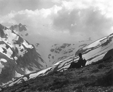
Mountaineering on Glacier Peak, close to Cool’s upper camp.
1955, Jack Wilson Collection
Rather than return to their base camp the next morning, they spent most of a day exploring to the southeast, toward what is now called the Honeycomb and Suiattle Glaciers. This area of impressive ice lies between Glacier Peak and the glaciers of the Napeequa Valley (the Napeequa is positioned directly east of the Cascade Crest). An arc of nearly continuous ice stretches from the summit of Glacier Peak to the north slopes of the Napeequa Valley’s Clark Mountain, a distance of over 10 miles. Although they did not venture far enough to the east to see the full extent of this backbone of rock and ice, the scene from the slopes of the Suiattle Glacier impressed Rusk. Glacier Peak was commanding on its own, with ice falls and rock buttresses blending into snowfields, and eventually parklands. Streams cascaded from melting snowfields and rushed across polished rock toward green parklands. Meadows were separated by groves of subalpine fir and hemlock lying beneath a series of cliffs. Scattered throughout were “flower-beds in all their brilliance, many-hued and fragrant”. [13]

A. L. Cool ice climbing, presumably Glacier Peak.
1906, Jean Renfro Family Collection
Late in the afternoon they returned to their bivouac camp, and began descending toward the bottom of the Suiattle River valley. This time their route followed some very steep slopes, alternating with forest and brush cover, ending at the bottom of the canyon where the river was surging over a boulder field.
Rusk described what he saw at the river edge as “wild in the extreme”. A forest of giant evergreens bordered both sides of the rocky, white water river. He caught views of the shoulder of Glacier Peak and the Tenpeak Range, framed between branches of trees.
They followed the river for a short time and found a gravel bar suitable for an evening bivouac, even supplied with dry driftwood for an evening warming fire.
Morning brought a spectacular sunrise, with red and orange coloration on clouds scattered across the highest summits. They quickly found a good crossing where a log-jam extended the full width of the river, and before long were beginning the long climb to their base camp near Buck Creek Pass. They hoped they would find their two pack horses grazing contentedly. The two tired mountaineers reached their welcome tent by late in the afternoon, with Benny and Johnny grazing nearby.
Their return trip to Cool’s homestead would be by an equally adventurous route. They would cross Buck Creek Pass and descend into the Chiwawa River drainage, then travel up Phelps Creek for a challenging climb over Ice Creek Ridge, finally dropping into the Entiat Valley.
The first part of their journey was not auspicious. The remnants of a forest fire were still smoldering some distance down the Buck Creek trail, creating some worry for the safety of Cool’s animals. At one point the trail was blocked by a part of the fire, forcing a detour down a difficult slope. The smoke was so thick Rusk thought it “strangling and blinding” and the ground was hot in places from smoldering embers. Suddenly Benny, who was being led by Cool, broke through the surface into a hole filled with embers, badly burning his hind legs. Both Cool and Benny struggled to gain safe ground, and after several anxious moments returned to the trail where Benny could be examined. Rusk relates their anguish and final decision:
Our hearts were torn with pity for the faithful animal. We discussed the advisability of shooting him on the spot; but we could not bring ourselves to do it, and, at last, we decided to give him a chance for his life. [14]
All of Benny’s load was transferred to Johnny, allowing Benny to travel slowly, even if painfully. They continued down Buck Creek until reaching Phelps Creek, a major tributary of the Chiwawa drainage, and turned to the north up the Phelps Creek trail. Cool planned to camp in the expansive meadows of the upper valley, now called Spider Meadows. The lower meadow is over a mile in length, nearly flat and quite broad, surrounded on its upper end by an arc of red-rock summits punctuated with patches of snow and ice. It remains a grand place today, even though overuse and careless camping have marred several of the camping areas. Rusk was impressed with its character. He had looked down on the upper basin two years earlier while on a side trip from Lyman Glacier. On that outing he had climbed to the high divide between upper Railroad Creek and the Phelps drainage, close to what is now called Spider Gap. But this time attention was focused on the difficulties of crossing the ridge to the north and descending into the Entiat Valley. Benny’s condition increased their concern.
The next morning Cool applied liniment to Benny’s hind legs and all four began the steep climb out of the valley toward the high divide that separates the Chiwawa from the Entiat drainage— Ice Creek Ridge. Rusk’s description of their ascent does not match well with today’s hiking trail up Leroy Creek, the most common present day route to Ice Lakes, their next camp. Cool may have chosen a different route, one beginning near Spider Meadow, then traversing into upper Leroy Creek at a high elevation to avoid most of the mid-level cliff bands. Regardless of the exact location of the first half of the day’s journey, Rusk’s description of the afternoon climb to the pass overlooking Ice Lakes is unmistakable. They crossed the high divide at the only possible location and dropped into the Ice Lakes Basin. Cool was certain their crossing was the first done with pack horses, and it may be the only one. The terrain is steep, with loose rocky footing most of the way, ending with a descent across a permanent snowfield. Cool’s detailed knowledge of the terrain eliminated false leads into dangerous terrain. Having hiked across this route many times, I am amazed at their success with an injured animal.
The lakes are high (the upper lake is above 7,000 feet) with gnarled larch and dwarfed whitebark pine set against a rocky, glaciated landscape. Deposits of pumice from an eruption of Glacier Peak around 13,000 years ago give an austere, almost eerie cast to the basin. [15] Ice Lakes’ high elevation and the evening’s clear skies meant a cold, autumn-like night. Fortunately, there was enough feed for the two animals in the meadows between the two lakes, so they fared well. Rusk watched the developing sunrise with anticipation:
. . . the sun crawled slowly up over the great earth—folds of the Cascades . . . At last came radiant warmth, and with it the energy to creep from beneath the blankets and prepare breakfast. [16]

Ice Lakes, below Mount Maude.
After an invigorating breakfast they began a short but remarkable side trip toward the snow saddle east of the summit of Mt. Maude. The snow at the saddle is not an isolated snowfield, but an extension of the eastern segment of the Entiat Glacier. From the col they looked into the spectacle of the upper Entiat Valley. In 1906 there was substantially more ice remaining from the surge of the Little Ice Age, in comparison to what we see today. The ice mass was greater in both surface area and total volume. The Entiat Glacier’s icefalls were directly beneath them, and even after experiencing the ice flows of Glacier Peak, Rusk was impressed with what he saw:
The wildly broken masses of snow and ice, at the upper end, clung with precarious tenacity to a thousand-foot precipice-rim that swing around the glacier-head in a perpendicular amphitheater. Directly opposite were the ramparts of the great peaks [Mt. Fernow and Seven- Fingered Jack] that look down on Railroad Creek. I know of few scenes of more awful, savage grandeur. [17]

Entiat Meadows by A. L. Cool.
Mount Maude (left) and Seven Fingered Jack (center).
1910, Jean Renfro Family Collection
Although they did not travel to the head of the Entiat Valley on this trip, it was part of Cool’s home country. The valley’s rim of ice and rock is striking when seen from the uppermost meadow. It is still imposing today, even with less ice than in earlier generations, especially with the contrast of ice, rock and meadow, linked by the ribbons of waterfalls flowing from hanging glaciers. Perhaps the valley is more interesting now than in Cool’s time, with a more balanced mix of vegetation with rock and snow. As a campsite the upper valley is a rewarding choice, although the sun sets early behind the height of Seven Fingered Jack. In the morning one is returned that loss—the sun rises early over a low portion of the Chelan Mountains just north of Pinnacle Peak.
By early afternoon it was time for Cool and Rusk to resume their journey to Domke Lake and trip’s end. They realized the route directly below Ice Lakes, a steep descent to Ice Creek, would be difficult for both animals, especially Benny. This segment of the trip was steeper and longer than the crossing above the lakes. Ever since Benny’s accident there had been an intense concern his injury might become so debilitating that he would have to be mercifully killed. This outcome was something both men desperately wanted to avoid. Rusk had decided he would accomplish this awful task if it became necessary, although he had not told Cool:
To a man of even ordinary sensibilities, it is a heart-breaking thing to have to kill a horse; and to the owner of the faithful beast it is almost unbearable . . . But we did not have to kill Benny. [18]
The route was slow, difficult and nerve-racking, but they eventually reached easier travel in the floor of Ice Creek. Benny’s injuries healed fully by next summer, and he traveled with full strength and agility on mountain trails for many years with Cool.
The final leg of their trip followed Ice Creek to its junction with the Entiat River, then descended the valley several miles to Snow Brushy Creek, where a long climb began to Milham Pass, the crest of the Chelan Mountains. This route is generally eastward, entering drier country lying many miles from the Cascade Crest. Milham Pass is the only easily negotiated route across the upper part of the Chelan Mountains. To the west the expanse of Fernow, Buckskin and Pinnacle Peak act as a serious barrier, and eastward the range is rugged until beyond Pyramid Peak. Even there access is constrained by the steep walls bordering Lake Chelan. This may have been the reason Cool found the area surrounding Milham Pass so productive as a hunting and trapping area—it was a primary wildlife corridor.

Cool’s Camp, Emerald Park, by A. L. Cool.
1920, Jean Renfro Family Collection
The first few hundred yards on the Lake Chelan side of Milham Pass is broken by groves of mature larch, growing on benches and talus slopes. These benches are a reasonably safe winter route from the pass down toward Emerald Park, and presumably were used by Cool while snowshoeing between his winter trap lines. Only near the bottom is one exposed to any serious avalanche potential, and then only under the most hazardous conditions. In less than a mile the summer trail reaches the open slopes above Emerald Park, opposite the valley from the steep, cold rock face of Emerald Peak. Only because of its height does the north face hold perennial snow. Emerald Park—an especially large and gentle meadow 3,000 feet below the summit of the peak—was the finale of what Rusk considered one of the outstanding trips of his life. The park is nearly flat, with areas of moist and dry meadows alternating between small meandering streams. They merge with the main stem of Emerald Park Creek before its descent from the hanging valley. The park was one of Cool’s favorite hunting camps, perhaps because groves of spruce and subalpine fir would give welcome protection from fall storms. But on this trip the weather was ideal as they left the meadow, only a few miles from Cool’s cabin and the end of a journey filled with great adventure and a remarkable variety of landscapes.
In addition to a glacier on Glacier Peak, Cool is remembered on today’s maps by Cool Creek, a high, remote drainage on the east side of the Spectacle Buttes, and by the Cool Creek trail, an infrequently used route which traverses high basins, eventually descending into the Entiat Meadows. Typical of the Cascade Eastern Slope, the Cool Creek trail passes through a wide range of topography and plant communities—from pockets of moisture-loving mountain hemlock, to the driest ridges where whitebark pine are the only conifers able to survive. The trail’s remoteness and continued wildness are appropriate to Cool’s memory. He spent decades hunting, guiding and trapping in Emerald Park and the Upper Entiat Valley, living in the high country for over half his life.
Cool’s life was extraordinary, and in recent years he has evolved into something approaching a legend. He received his education in New York at Syracuse University, and moved west to pursue a career as a railroad bookkeeper and agent. Cool’s last formal job was in Spokane, working for James J. Hill’s Great Northern Railroad. In 1894, while living there with his wife and four children, he was diagnosed with a terminal kidney ailment that doctors believed would end his life within six months. Soon thereafter, he left his family to live the remainder of his life in the Chelan Mountains, moving into a cabin at Domke Lake as a squatter, shortly before the area became part of the National Forest System. The lake lies in a forested basin about a thousand feet above the elevation of Lake Chelan. Cool’s diagnosis turned out to be wrong in the extreme. From his homestead as a base, he spent more than 40 years traveling the Chelan Mountains, not only mountaineering and trapping, but guiding others on hunting, fishing and sightseeing trips.
Cool was no recluse, promoting his camp as an ideal base for paying guests to enjoy the Cascades. He used his notoriety as a Northwest and Alaskan mountaineer to help sustain his business enterprise. Rusk, his long-time climbing partner and personal attorney, helped with newspaper articles describing their adventures. Cool was an active photographer, taking hundreds of photos of wildlife and mountain scenery, some published by Rusk and other writers. Unfortunately, most were destroyed when his cabin burned in the spring of 1941, although a small number had been sent to his oldest daughter. The fire also killed Cool—at the age of 82. [19] He has been credited with naming Mirror Lake, which lies over a divide from his favorite Emerald Park country. For a short time Cool worked as a ranger for the newly formed Forest Reserves, when his knowledge of the Lake Chelan country proved valuable to National Forest administrators G. W. Milham and D. B. Sheller, during a 1904 wilderness tour of the upper Stehekin Valley (including an ice-filled Horseshoe Basin). After visiting the upper valley, Cool guided the group eastward over the divide into the Twisp Valley, eventually returning to the head of Lake Chelan. [20]
His exploits as a bear hunter were astounding, but from today’s perspective could be viewed as excessive, although he prided himself in always using what he had shot. Even though his trapping and hunting might appear to define him as similar to a classic, historic mountain man, what sets him apart was his interest in mountaineering and mountain photography, and his esthetic sense for the high country. Cool was singular.
I hiked the length of the Cool Creek trail in mid-September 1997, beginning at its northern end in the upper Entiat Meadows. Autumn had not arrived early that year, the large meadow below Buckskin Mountain was still mostly green, with only a hint of the golden brown that would soon dominate the Entiat Meadows. Groups of conifers that separate the meadows are a mixture of subalpine fir and spruce, with the spruce noticeably older than the fir. Although this was not surprising (spruce are considerably longer lived), their differences seemed especially apparent that day. The taller spruce were thick with brown, pendant cones for the top quarter of each tree, giving a distinctive cast to what, otherwise, would have been uniformly green spires.
Beginning a hike of the Cool Creek trail from the Entiat Meadows requires a cold ford of the Entiat River, thankfully an easy one on this trip, with a low flow level late in the summer, and the main stream’s proximity to its headwaters. I could not help thinking that Cool, decades earlier, must have done the very same thing many times. Immediately after the ford the trail began to fade from lack of use, but then reappeared as it entered the forest, climbing steeply through a moist, north-facing forest of hemlock and silver fir, eventually reaching a semi-open basin. Fir and hemlock began to be replaced by alpine larch, some of impressive dimension. An old campsite was barely noticeable under a large grove near a stream crossing, conveniently close to water, but clearly, rarely used, if not completely abandoned. Log rounds, cut for seats, were melting into the vegetation. They could have easily gone unrecognized.
After a short climb the trail crossed a gentle saddle, where larch trees were spaced widely enough for a view toward the upper Entiat Valley and Mt. Fernow, the highest summit of the Entiat Cirque. There were few obstructions looking the opposite direction toward Pinnacle Peak. The high meadow extended a hundred yards, giving a sense of openness and light. As I was about to leave, a Clark’s nutcracker began removing seeds from the cones of a large whitebark pine, pecking, working feverishly, collecting as much of its favorite food as it could. I believe Cool would have enjoyed the scene.
Chapter 8
Miss Wheeler’s Solo Pack Trip–1932
For 43 days, from the end of July through the first week of September 1932, an energetic and independent young woman, whom we know only by the name of Miss Wheeler, hiked solo through a major portion of the Eastern Slope of the North Cascades. She led her pack horse, Tommy, from the upper Little Wenatchee River north, through the upper Stehekin Valley, eventually reaching the Pasayten country near the Canadian border. She continued into the Skagit Valley (west of the Cascade Crest), returning to the upper Stehekin area and the Cascade Eastern Slope, finally crossing Buck Creek Pass and completing the loop at her Lake Wenatchee starting point. Her journey was nearly 300 miles, passing through an exceptional variety of Cascade landscape. She kept a daily journal of her trip, filled with personal impressions: sometimes feelings of frustration or fatigue, at other times the joyful experiences of ridge-top views or mid-summer bloom in high meadows. [1]
Her diary is not explicit as to the motivation for the trip, but I have assumed from the general character of her remarks that she was simply seeking a genuine, major adventure—and indeed it was. Her journey was arduous, with hundreds of miles of trails up and down steep ridges and over passes, from the beginning of her trip until its end. On many occasions trails were poorly signed and maintained, adding to her challenges. From remarks throughout her narrative, August of 1932 appeared more rainy than most, which always adds difficulty to a long journey through the mountains. Her pack horse, Tommy, was rented from a Lake Wenatchee area owner. Her diary does not suggest any great experience as a packer or horsewoman, at least not at the trip’s beginning. She learned about stock packing on the trail as the days went by. Especially when packing solo as a novice, gentleness and experience on the part of the animal are more vital than speed of travel. To Miss Wheeler’s relief, Tommy was old and gentle with a calm disposition, even though at times he was slower on the trail than she wished.
To the good fortune of latter generations, Miss Wheeler forwarded her diary to the Supervisor of the Chelan National Forest the November following her trip, even though it was apparently not written with that purpose in mind. It has remained in Forest Service records since then, giving us one woman’s perception of a summer in the Cascades. The staff was especially interested in her comments about inadequate trail signing, poor maintenance and her reaction to Forest Service facilities in general. The Chelan National Forest Supervisor sent a cover letter concerning her comments on trail conditions to selected district rangers, making it clear he expected improved signing based on her critique. The early 1930s was a time of growing interest by the agency in more active management of the trail system. Many of the trails had been built by sheepherders and miners over the previous decades, sometimes with poor design. Inadequate design had exacerbated problems of drainage and general maintenance, making travel more difficult than it might otherwise be. By the early 1940s, years of Forest Service supervised Civilian Conservation Corps work (which had begun in the middle 1930s) helped to transform the inherited system of sheep routes and old trails into an impressive network of interconnected trails. [2]

The Route of Miss Wheeler’s 1932 Adventure
Some passages from Miss Wheeler’s diary suggest she maintained a close connection with staff on the Wenatchee and Chelan Forests. Wallace Wheeler, who may have been a relative, was Entiat District Ranger in the mid-1930s. This could explain why some of her stops at Forest Service guard stations appear to have been anticipated. Several of the guards were expecting her arrival and were prepared to offer assistance. But not all individuals she met were friendly or helpful. Whether this was typical of the reception from some individuals to a woman traveling alone in the 1930s is perhaps speculative. Certainly her journey was unusual and required special determination and physical endurance. Many of her travel days were long and done under difficult conditions of weather and terrain. Of interest to today’s traveler is the number of other people she encountered during her 43-day journey. They included Forest Service crews, miners, recreational hikers and horseman—a level of activity in the high country that some might find surprising for 1932. In reality, from the end of the 19th century to the present, the high county has had a significant amount of human use, especially during the first third of the 20th century. Mining and grazing were especially active, although recreation was beginning to have a considerable impact.
Miss Wheeler began her adventure on the afternoon of July 27, 1932 at the end of the Little Wenatchee road, about five miles from the present road end. Hiking nearly six miles that afternoon, she made her first camp a mile above the Cady Creek trail fork. Sheep had traveled the same route a few days earlier, but had branched off on the Cady Creek trail toward the Cascade Crest, rather than follow her route toward Meander Meadow.
Was tired but relieved to do as well as did . . . clear starry night with Milky Way. Slept fair, but had usual time getting settled. Camp inconvenient—had to build fire in meadow and hang hammock in timber—heavy dew and everything wet this a.m. Will do better tomorrow. Dread packing ... such a load. Awfully nice horse—real dear—but he is awfully high.
The first few miles above her campsite were gentle, easy hiking through sections of old growth forest, with alternating open swaths created by years of snow avalanches. By late morning she had reached the end of the main valley and faced the steep climb to Meander Meadow. As they began their climb the sun was hot and there was only occasional shade from scattered silver fir and hemlock. Both Miss Wheeler and Tommy struggled where the trail was steepest, with little relief until they finally traversed into Meander Meadow, the afternoon’s destination. Tommy munched fresh grass while Miss Wheeler bathed in the nearby creek. She prepared an early supper and then went to bed, tired but refreshed from her bath. During the evening clouds moved into the basin from the west, obscuring the stars and bringing some lightning and a few drops of rain. Although the morning was overcast, the meadow’s mosaic of early spring changes was refreshing.
It was 7 before I got up. In this meadow it is early spring—a few patches of snow lie on slopes around it but much of meadow is still covered with last year’s dry grass thru which new vegetation has not yet grown. It is primarily a grass meadow but I saw flowers in places— light lavender violets, large almost double buttercups, and lots of purple birds bills. There will be Indian Paint Brush later. On ridge, heather is blooming in spots. I hope it will clear soon. I will move over into Indian Pass today and pitch tent and wait there till it clears.
She could hear grouse drumming, even over the sound of the creek as it flowed from the basin and plunged toward the lower valley. Meander Meadow is a classic hanging basin with a steep drop to the valley floor of over a thousand feet. The expansive meadow offers different textures and colors, as it passes through spring, into full summer and finally into fall. Sylvester named it in 1912 because of what he termed the stream’s “bewildering convolutions”, and the name has lasted. [2]
The weather had improved by next morning, so her climb over the shoulder of Kodak Peak [3] toward Indian Pass rewarded her with a horizon filled with rugged peaks, including Glacier Peak to the north.
Trail around Kodak Peak good and view was certainly fine, as it was from summit—the whole horizon was lined with one jagged peak after another . . . Kodak Peak is covered with grass and flowers. I saw yellow glacier lilies, little short stemmed buttercups, one large flower on each stem.

Meander Meadow
Because Indian Pass is less than a half-day travel from Meander Meadow, she decided to lay over a day at the pass, and use the extra time for climbing to the summit of the inviting peak to the north. Indian Head is an impressive peak from the ridge above Indian Pass, with an unobstructed view of the surrounding landscape whenever the weather is clear. Although not especially high, its elongated shape and blend of rock, snow and deep green flanks give it a distinctive appearance. Indian Head is the same peak Linsley and Tennant climbed in early July of 1870 while searching for a railroad route (Chapter 6). Miss Wheeler camped in the meadows at the pass where clumps of old hemlock could give some protection from a storm. Clouds were threatening in the west as she prepared dinner, bringing a gentle shower by sunset. The next morning brought a short weather break.
Brilliant dawn—all blue and gold—clear sky overhead very blue. A waning moon, now a mere crescent—rises about 2 hours before dawn. Morning star—very bright—follows about an hour—both visible at dawn . . . Indian Head covered with frost this morning . . .This is a beautiful vale—grouse drum early and late. Across meadow on gully down Indian Head is a hillside red with columbine, and below another bank blue with a tall-growing small bell flower [probably bluebells]. Mountain heliotrope very thick here—yellow daisies, buttercups, anemonies, etc. Shower is over—will wash up from breakfast and get ready now—8:15.

Glacier Peak and shoulder of Indian Head mountain (right).
The weather was showery with occasional sun breaks, but never clear enough for as much as a glimpse of Glacier Peak. She climbed to the west spur of Indian Head and huddled behind some krummholz for a quick lunch, eventually deciding it was too wet and overcast to continue the ascent. After dropping to nearly the elevation of the trail, the weather improved appreciably, or at least enough to justify hiking north toward White Pass for the remainder of the day. A mile short of the pass she met two sheepherders with their band, and received help in sorting out the best route to the north. Multiple trails, created by the movement of sheep, had complicated finding the best route to White Pass. Remnants of some of these trails are visible in the sod today, although there is no question now which is the main trail. Today’s Pacific Crest Trail is wide and has a considerable presence on the landscape. She found the pass radiantly green, with scattered snow patches remaining on the east side of the divide. Few places in the Cascades have the balance of colors and textures to equal White Pass, especially with Glacier Peak and the White River Glacier as a backdrop.
The following day Miss Wheeler left the Pacific Crest and descended the Indian Creek Trail to its junction with the White River. From this point she hoped to travel up Boulder Creek to Boulder Pass, dropping into the North Fork White River (later renamed by Sylvester the Napeequa River). From the Napeequa River she planned to climb over Little Giant Pass and descend into the upper Chiwawa drainage—final access to Buck Creek Pass and a return to the Cascade Crest. In the early 1930s both passes were challenging routes, Little Giant Pass remaining so today. In 1932 the Boulder Creek Trail was nothing more than a very steep sheep driveway, useable only if cleared of logs. Parts of it are visible today from a few locations along the modern trail, but it is difficult to recognize without prior knowledge and some searching. Brush and young trees have nearly obscured it. The route is so steep that descending requires care and some skill to avoid slips.
Miss Wheeler and Tommy arrived at the small Forest Service guard station where Indian Creek flows into the White River. Several feet of the cabin’s log walls remain today, party hidden by brush and young trees. Lake Wenatchee District Ranger Lindahl was at the cabin, and offered to help her in crossing the White River. The White can be a serious obstacle to foot travel in early August, especially this far from its headwaters. Lindahl led Tommy across, with Miss Wheeler and her dog Mick riding behind him on his horse. He wished her well, and indeed her good fortune continued for a short time. She had no difficulty finding the beginning of the Boulder Creek route, but after a halfmile of good travel, they began struggling up the sheep driveway, meeting a number of serious obstacles. Down logs combined with the steep slope made progress excruciatingly slow. Tommy became tangled on several occasions, and at one point his safety was in jeopardy. In the end, the route was abandoned and a forced camp made amid frustration: “Feel awfully tired and feel disgusted with whole trip.”
She had little choice in foregoing the Boulder Creek route for a longer, but more feasible route to the upper Chiwawa. The trio turned downstream and traveled down the White River trail to the road and Meadow Creek, eventually connecting to the lower Chiwawa drainage. This path was circuitous but provided certain access to the Buck Creek Trail and the country to the north. Their camp in Meadow Creek was not ideal but adequate:
Is warm tonight. Took bath and changed clothes—first time since left Meander Meadow—been too cold. Been leaving not only underwear but sweater on as well . . . Made camp 5 p.m. tired but first place with both feed and water since left pass. When went up for Tommy this morning, coming back, met a nice deer in trail at sudden turn within sight of camp. This is a county game refuge and lousy with game. Trail seems to be traveled mainly by deer. Lots of bear tracks too.
The next two days were spent leading Tommy up the more than 20 miles of the Chiwawa Road to the Trinity Mine and road’s end. It was now the first week of August and warming weather, making the deer flies bothersome during the day. The morning and evening were reserved for aggressive mosquitoes. In 1932 the Buck Creek trail was not as well designed as the one used today. Rather then following contours and climbing steadily and evenly, it had the characteristics of a sheep trail, going up and down ridges, taking advantage of every possible meadow for feed—an indirect route but meeting the needs of the sheepherder.
Approaching the pass she noticed there would be company during her stay; a troop of Boy Scouts (50 in all) had an encampment at the summit of Buck Pass. Three of the scouts were swimming in a deep pool along Buck Creek, and offered to lead Tommy the remaining half-mile to a good campsite with a view of Glacier Peak. The breeze she hoped to find never developed, giving no relief from the mosquitoes and flies that she judged to be “bad”. At this point in the trip she admitted to being “terribly tired,” so the next day was spend resting in and around camp, keeping out of the sun as much as possible to give some relief for her sunburned face. The weather continued warm—ideal for flies. Tommy was affected the most, bitten so much around his neck by flies that it became “bloody.” The following morning she broke camp at 8 a.m. and began a long day traversing the upper Suiattle drainage.
The day’s travel to Suiattle Pass was one of the most trying of her 43 day adventure, even though it included spectacular views of Glacier Peak and the Tenpeak Range from the trail’s high point on Middle Ridge. After descending from a low saddle along the ridge they were faced with crossing Miners Creek, and also dealing with the relentless insects. She removed her boots and socks, and rolled up her pants, expecting a lively ford:
Water looked about knee deep—milky white, bottom covered with rocks and boulders. Flies terrible along creek—had to stop twice to knock horse flies off my face—horse equally pestered—bottom very tough on tender feet—horse threw head against me and I fell headlong in water—saved myself from going under by grabbing a boulder a few inches under water—got out on bank terribly cold and wet—started to cry but flies so bad had to give it up—pulled boots on over wet feet and beat it up bank—had expected to eat lunch here and rest but insects would not permit any tarrying. Trail on to Miners Ridge graded and less exhausting than feared, but hot and dusty . . . Mosquitoes here make life a misery—night warm with sheet lightning—many falling stars—have burnt face especially around eyes—but was not as tired as at Buck Creek Pass, the trip harder I believe.
A most welcome camp was set just south of the pass for the evening, placed high enough to provide a breeze, and relief from the bothersome flies. She needed a change from the heat and insects, which this camp and the following few days would provide. The next day was planned as a rest day, a good strategy considering the many miles to travel down Agnes Creek to the Stehekin River and another Forest Service guard station. A day and one-half were used in descending the Agnes Valley, which is mostly forested, but with some dramatic views of Needle Peak, Saddle Bow, Agnes Peak and other high points along the valley.

Glacier Peak and Flower Dome from near Buck Pass.
Fortunately the weather cooled some, helping to make the walk especially pleasant. Flies had subsided to tolerable levels, and the salmon berries were beginning to ripen along the trail, an unexpected delight while leading Tommy. Late in the afternoon she met several family groups on horseback traversing the Cascades from the Eastern Slope to the Suiattle country, providing a relaxing, social interlude for this friendly, but self-reliant young woman. Camp for the evening was made in an open pine stand, several miles short of the High Bridge Guard Station.
This is about the nicest place camped yet, down in pine timber, good feed, no insects, what a relief . . . On account [of the] showers and clouds put up tent tonight . . . feel rather tired but otherwise O.K. My face so badly burnt it is peeling . . . Glad weather cooler.
The next morning Miss Wheeler stopped for a short time at the High Bridge Guard Station and enjoyed a visit with the guard and his wife. These historic buildings, which include a house, barn and out-buildings, are well maintained and still used by the National Park Service as part of the North Cascades National Park. Mt. McGregor dominates the guard station to the northeast, its granite bluffs and summit ridgeline rising nearly 7,000 feet above High Bridge. The High Bridge area is relatively dry, a good site for ponderosa pine and drought tolerant shrubs. Not surprisingly, considering the habitat, I once startled a resting rattlesnake while walking along the Coon Lake trail a short distance from the guard station.
She thanked the couple for their hospitality, and by late morning continued up the Stehekin Road eight miles, and then two additional miles up the Bridge Creek trail before making camp for the evening. The following day they traveled up the remainder of Bridge Creek, meeting several groups of prospectors along the way before approaching Rainy Pass around noon.
Am nearing Rainy Pass—quite an appropriate name. Writing at noon. Sun has come out so will move along. Good grazing along here, but see some larkspur.
Traveling was enjoyable up Slate Creek heading toward Washington Pass, with little climbing required between the two passes. Huckleberries were ripening along the trail in some of the more sun-exposed areas. Not surprisingly, bear sign was everywhere. She picked several cups of huckleberries for some special bread that evening, before continuing on toward Washington Pass, one of the most imposing points along her journey.
There are perpendicular cliffs with jagged edges standing on all three sides of the head of Early Winters Creek . . . very spectacular. Bridge Creek side ascent very gradual and pass pretty with large meadow and prominent rock peak standing to east called Liberty Bell. Cliffs at head of Early Winters Creek also seen thru pass, and seem to block pass.
Today, the North Cascades Highway crosses Washington Pass and descends Early Winters Creek toward Mazama and the lower Methow Valley, eventually reaching the Columbia River. In 1932 the route was a trail from Mazama westward, so it was mostly wild, with only a few trapper and prospector cabins. Although nearly 70 years have brought drastic changes to the valley, a person can still be in awe of the abrupt granite walls of Liberty Bell and the ruggedness of Silver Star Mountain. The fascinating transition in plant communities that takes place between upper Bridge Creek and the pine stands of lower Early Winters Creek is still there to see, even if the wildness of the valley has been lost.
Reaching Mazama meant farms, fresh vegetables, social contact and an opportunity to re-furbish equipment. She noted in her diary that there were “a considerable number of farms along the river near Mazama, with nice gardens and green fields”. Feeling comfortable with the surroundings and confident in how she would be received, Miss Wheeler stopped at one of the farms and asked if she could feed Tommy on pasture grass. The family was predictably gracious, inviting her to share their supper as well. While preparing to pack Tommy the next morning, Miss Wheeler was surprised by her new friends with a full bag of fresh vegetables—corn, beans, beets and cucumbers.
The Lost River Ranch was her next stop—north and west of Mazama and a gateway to the Pasayten country. A day spent at the ranch meant Tommy could be freshly shod, at this point in their trip a necessity because of the many miles of rocky trails ahead. On the morning of August 16 Miss Wheeler and Tommy were ready for the Pasayten country, taking the trail up Robinson Creek to Robinson Pass, then descending into the broad Middle Fork Pasayten River, which drains northward toward the Canadian Border. Much of the upper valley had burned during the previous decades. She reached Robinson Pass at 11:30 a.m., and traveled most of the afternoon—six or eight miles—through a large burn, extending “from one ridge to another”. A healthy stand of young lodgepole had become established among the remaining snags, creating a dense carpet of green. Even though ready to camp earlier in the afternoon, she felt it was prudent to continue some distance beyond the old burn because of its unpredictable snags:
There was a high wind in the pass, and as I passed thru burnt timber, I could hear trees falling down near the creek where the wind seemed heavier. Practically all the snags are still standing.
Hiking this route today, it is not as apparent that large fires burned during the early decades of the 20th century. A few remnant snags standing above the new forest are visible from the trail, but the casual visitor could easily pass them without any idea of their significance. The young trees that were only seven or eight feet tall in 1932, growing under burned snags, are now 70-to-80 years old, and mask most of the obvious signs of the earlier fire. The mostly uniform, even-aged forest is the most telling indication today.
Continuing north, Miss Wheeler reached an airstrip along the Pasayten Middle Fork under construction by the Forest Service. Isolated from the nearest road by nearly 30 miles, all clearing and contouring were being done with draft animals and human power. Sylvester visited the same project during his trip with Chelan National Forest officials the very same summer of 1932 (Chapter 5 includes Sylvester’s description of the Point Defiance viewpoint). As could be expected, Miss Wheeler was invited to join the crew for their mid-day meal.
. . . lamb two ways, potatoes, baked beans—awfully good, squash fresh, tomatoes, 3 kinds bread, rice pudding, new applesauce, jam pickles, I don’t know what all. I feel so much peppier this P.M. Maybe I don’t get enough variety to eat.
She continued traveling north that afternoon, and by early evening was heading west up Rock Creek from the Three Forks Junction. Camp was about two miles up the valley, placed in a meadow where she had a clear view of Point Defiance. She could see the summit lookout house several miles away across the Middle Fork Pasayten Valley.
This is a nice place to camp—open meadow with flowers—dark purple bell flower—very common in these parts, also tall lavender asters. Meadow full of grasshoppers, creek full of fish . . . Got away about 10:30 and came up into Woody Pass. The sheep are in the pass, and I approached, I heard the inevitable horse bell . . . Did not go close to sheep, but came on down about 1/2 mile and camped below the cliffs on steep hillside . . . Trail up Rock Creek goes mostly through open side hill meadow—good view out. Cliffs stand at head of creek, very high and rugged.
The next three days were spent traveling the ridges and passes along the Cascade Crest, then through the Deception and Devils Pass areas to the west, finally descending to the mine buildings at Chancellor. The main trails were poorly marked, and adding to her confusion were dead-end spur sheep trails diverging from the primary route. Trial and error was often the only way of finding the correct route, but it required much time and energy and was frustrating, especially so when alone. The trails she traveled along the crest were primitive in comparison to today’s Pacific Crest Trail—steep, rocky and not always easy to follow. The trails from Deception Pass to Anacortes Crossing, which led to Chancellor, were no more than sheep trails. Their vagueness was not troubling to sheepherders regularly using the trail system, with their intimate knowledge of the country. Even though some baffling moments were experienced, she enjoyed being on the high ridges with their outstanding views, good camping and sense of isolation.
From Chancellor Miss Wheeler descended the Canyon Creek trail, passed the Granite Creek Guard Station, and finally reached the Diablo Guard Station—two days travel over rough and rocky trails. At this point of the trip her boots were falling apart, and either repair or replacement was mandatory. The nearest stores were in the Skagit Valley, at either Rockport or Concrete, an interesting interlude from wilderness travel. Tommy was left grazing in meadows near the guard station, while Miss Wheeler left on the tourist train from the dam and reservoir (run by Seattle City Light) to Newhalem, and from there traveled by automobile to Rockport. She felt slightly out of place among the tourists.
Saw myself in glass and if I don’t look like some old squaw—face burnt and peeling—clothes dirty and ragged and weather beaten all around.
The new boots were heavier than what she would have liked, but they were durable and would suffice for the long hike back to her starting point at Lake Wenatchee.
From Diablo she planned to climb the long, but relatively well maintained Thunder Creek trail to Park Creek Pass, and then drop into the upper Stehekin Valley. She wanted to leave behind the summer’s dampness by crossing to the east side of the Cascade divide. A friendly Forest Service packer at Diablo gave her some valuable advice on the locations of several cabins along Thunder Creek, as well as nearby, but hard-to-find meadows, where there would be feed for Tommy.
The Thunder Creek trail was good traveling, following the gentle valley bottom for most of the distance. By mid-afternoon showers developed, accompanied by distant thunder as she approached the 10-mile cabin. Where the trail passed through old-growth timber it was not wet, the canopy so dense it caught most of the moisture. But in open areas she was quickly soaked from the waist down, where ferns, brush, tall grass and nettles were drenched with rain and bent over the trail. That evening at camp she “poured water out of [my] new boots when I took them off—not that they leaked—merely ran down my legs”.
She spent the night at the 14-mile cabin, using the front porch for shelter and sleeping on a cozy bough bed inside the main cabin. Tommy had good feed nearby, and Miss Wheeler found an abundance of ripe salmon berries all around the cabin. Crossing the pass the next day was cold and wet, with a constant drizzle turning to snow as they neared the top of Park Creek Pass. Just as she reached the summit the skies partially cleared, giving a last good view down the expanse of Thunder Creek. This is severe and spectacular country. To the southwest Mt. Buckner and Boston Peak rise to over 9,000 feet, with the mass of the Boston Glacier flowing off their flanks into upper Thunder Creek. The ice, cliffs, waterfalls and the deep green of the valley are definitive North Cascade landscape.
She hoped to escape the main strength of a series of storms by returning to the Stehekin Valley and its drier climate—at least drier than Thunder Creek. To her chagrin, the storms were intense enough to keep the Stehekin and Agnes country cool and damp for several days. They walked by the first meadow just east of the pass, camping at a larger parkland about four miles away, but still in view of Mt. Buckner. Like the sweet huckleberries she sampled at the head of Thunder Creek, the meadows of Park Creek were filled with ripe, wonderful berries. Tommy had abundant feed a short distance from camp. After supper it began to rain, but it was not a warm summer rain: it “lasted all night and cold—went to bed with both sweaters on and underwear”.

Mount Buckner from near Park Creek Pass.
The weather continued cool and moist as they traveled down Bridge Creek toward the High Ridge Guard Station and the beginning of the Agnes Creek trail. On the evening of September 1 camp was made at a cabin close to where Swamp Creek enters the Agnes Valley, about half-way to Suiattle Pass. The trail was damp most of the next day, especially the overhanging brush and grass. Just as Miss Wheeler approached Suiattle Pass the weather began to change—a moist summer was nearing its end. As she reached the summit the sun came out, creating a shimmering rainbow in Agnes Creek and an unobstructed view of Glacier Peak. Camp was made a short distance from the pass along Miners Ridge in one of the vacant mining claim cabins. It was a good night to be sleeping inside:
. . . Slept on cabin floor . . . Turned clear and very cold. Froze hard—everything covered with frost and ice. Huckleberries frozen solid. There is much new snow on higher peaks—looks very wintry.
For the remainder of the trip the weather was ideal; four days of clear weather, with warm days and cold nights. The next day-and-a-half were spent traveling between Miners Ridge and Buck Creek Pass. She felt tired, for this section of trail includes steep climbs and descents, but the scenery was more than adequate compensation.
Brilliant day—extremely clear and warm in [the] sun . . . View was wonderful from high country, Glacier Peak standing out clear the entire day, and many other mountains.
Her mood was soaring, now that she was past the 3/4 point of her trip, feeling strong and enjoying ideal early fall weather. All of this tended to mask-over earlier days that were hot and buggy, or cold and wet. Her last camp in the high country was four or five miles east of Buck Creek Pass, at the last meadows before the dense, lower valley forest develops. It was now late enough in the season to eliminate any chance of insects. September also brings intense colors to the high country; the remaining greens are richer against the seasonal yellows, reds and oranges of autumn.

Tenpeak Range from near Buck Pass.
This is a beautiful place to camp—low red mountain ash bushes like a flame with berries—open timber—fine place—old sheepmen’s camp I guess. . .Took a picture here.
The last two days of her adventure were spent in the lower Chiwawa Valley headed for Lake Wenatchee. This last segment of her journey had included dozens of miles but easier traveling, compared to the previous 40 days of wilderness travel. The journey had taken Miss Wheeler through a range of emotions and experiences, with periods of discouragement and fatigue. But at other times she was moved by the beauty of the Cascade’s— sometimes in powerful ways, and at other times more elusively. That contrast is a defining characteristic of remote, wildland travel in the Cascades, whether solo in 1932 or today.
Chapter Nine
Hard-Rock Miners of Phelps Creek
Today’s long-established hiking route from Spider Meadow to the foot of Spider Glacier is the crux to crossing into Lyman Basin through Spider Gap, but it is difficult to detect from a vantage anywhere along Spider Meadow. Even after closely studying the rock faces and alpine terrain that skirt the small glacier’s outflow waterfall, one might conclude that mountaineering skills are needed to reach the high divide. At the end of the nearly mile-long meadow, the Phelps Creek Valley takes an obvious turn to the right into Phelps Basin, leaving the north side of the valley flanked by a series of cliffs and waterfalls. Rising high above the first tier of cliffs, the East Peak of Chiwawa and Red Mountain complete the impression of a formidable obstacle to travel. Only after crossing Phelps Creek and reaching a trail junction some distance from the valley bottom, is there any indication that a route climbs directly out of the valley. The trail is steep, but obviously designed and constructed with considerable thought, winding its way through a series of cliffs, scratched into a rocky mountainside holding little soil. After a thousand feet of climbing and airy views toward Spider Meadow, the trail traverses onto rock rubble at the edge of Spider Glacier, and the beginning of the easy snow route to Spider Gap. While decades of infrequent maintenance have left a deteriorating tread in some sections of the route, it has retained much of its original character.

Spider Meadow, East Peak Chiwawa Mountain (left).
1950s–Jack Wilson Collection.
This intriguing trail was not constructed by sheepherders or early day Forest Service crews, but by hard-rock miners working laboriously, creating a route for hauling their equipment and supplies to a small mine a few hundred yards beyond Spider Gap, in clear view of the Lyman Glacier. The mine was the creation of John “Ed” Lindston, an independent minded, durable and very determined entrepreneur of Swedish lineage. [1] In the summer of 1923 Ed Lindston—sometimes helped by his brother Fritz and friend Henry Hadley—scratched out the trail from near the edge of Phelps Creek to the shoulder of Chiwawa’s East Peak at the foot of Spider Glacier. From this point their route followed the mid-course of the snow and ice filling the halfmile- long trough of Spider Glacier, an easy climb free of crevasses. The glacier’s modest scale and moderate gradient created a feasible over-snow travel route where Lindston could lead his mules and horses laden with heavy mining equipment. The trail below the glacier did have its difficult sections, especially several areas where a stumble could cause an animal to plunge down a rock face. Over a period of years Lindston lost several of his pack animals along critical sections of the trail.
With their trail completed by autumn, the next summer— 1924—was filled with work on the mine itself, dubbed the “Galena King”. Drilling and blasting of the main tunnel—termed an adit in the language of hard-rock mining—consumed much of their energy, with additional labor needed in blasting a shelfshaped sleeping area. Wood framing completed a shelter large enough for six or more people. The “Galena King” was no trifling effort, and included as equipment a forge, anvil, wheelbarrow, lengths of metal pipe, numerous drills, a model T engine, sheets of tin and wood. Much of it was visible when Lindston’s grandson first visited the site in the mid-1950s, including three sticks of dynamite. The heavy anvil was stamped “Birmingham, England” and dated 1909. [2]
The mine entrance faces the Lyman Glacier and the summit of Chiwawa Mountain, giving it a legitimate alpine setting. Because the site is rocky and free of vegetation, its appearance is austere compared to the benches and rock faces surrounding the route up Spider Glacier, which in contrast seem rich with life—mosses, clumps of heather and dwarf larch trees. I have never looked closely at Ed Lindston’s mine, although I have crossed Spider Gap over a dozen times, intent on different goals. Indeed, I am thankful the project remained small and only partly developed, thereby retaining the beauty of the area. But I do wish to remember and respect Lindston’s strength of character, and the legacy of the remarkable trail he built.
1924 turned out to be an eventful year for Lindston in a less fortunate way. During the autumn work continued on the mine, their drilling and blasting taking the three miners deeper into the mountainside. Lindston had finished the lighting of eight fuses and was evacuating the mine tunnel, when a blast occurred sooner than expected. Fly rock shattered his right ankle and struck his back, but he was able to struggle to the mine entrance. His brother Fritz and friend Hadley cared for his injuries the best they could, and then began the arduous task of carrying him to the road’s end. They used a cot from their sleeping area as a stretcher, reaching the gap in less than an hour, then down the glacier and the trail for an evening’s painful stay at the empty cabin near the bottom of the switchbacks. The next day they completed the three-mile carry to Leroy Creek—the end of the mining road in those days—where Lindston had parked his truck, an REO Speed Wagon. They reached Wenatchee that evening, where Ed’s broken ankle was set by a physician.

Members of Lindston’s extended family on the switchback trail to Spider Glacier.
1930s, Lloyd Berry Family Collection

Shelter near the Galena King mine.
1930, Lloyd Berry Family Collection
Although the mine consumed considerable effort and time, it apparently never reached the status of becoming financially rewarding. Like most hard-rock mining in the area, the labor was far in excess of any monetary reward. But Lindston’s mine was unique in its high elevation setting above Spider Gap, and in the frequent use his well-built trail continues to support. As the only practical route between Phelps Creek and Lyman Basin, it has become a valuable recreation trail, although few travelers are aware of the details of its origin.

Lower Lyman Glacier from near Spider Gap.
1930, Lloyd Berry Family Collection
Lindston’s labors had been preceded by several decades of intensive prospecting and mining by others in the area, some beginning as early as the last decade of the 19th century. At the same time prospectors were swarming over the Peshastin Creek area near Leavenworth, and climbing among the steep cirques of the upper Stehekin, miners were also discovering promising ore bodies in the Phelps Creek and upper Chiwawa areas. Phelps Ridge, dividing the two drainages and culminating in Red Mountain and the East Peak of Chiwawa, was an area of intense interest.
One of the genuine characters of this period was “Red Mountain Ole”, whose legal name was Johan Smeds, a solitary fellow who lived, prospected and trapped in Phelps Creek until 1935. He discovered several important claims that later became part of the large Royal Development Mine at Trinity, located near the confluence of Phelps Creek and the Chiwawa River, receiving a yearly stipend as compensation. Ole’s first cabin was built about a half-mile beyond the current Phelps Creek trailhead, tucked away on a bench a short distance above the old mine road, surrounded by hemlock, spruce and subalpine fir. He also had a cabin in a grove of sub-alpine fir on the east side of Phelps Creek, not far from where Lindston’s switchback trail leaves the valley floor. [3] It burned in 1925 and was never rebuilt. Another cabin—not Ole’s—was located on the west side of the creek and very close to the valley trail, and was the cabin Lindston used while suffering from his broken ankle. Now only an open, flat area remains, with some meager remnants of sill logs from the cabin foundation. The site is used frequently by backpackers as a campsite, although I expect few realize what existed there less than a hundred years ago.
Ole’s lifestyle was geared to the rhythm of selling furs in Leavenworth, receiving food credit for bringing in small quantities of ore, and using his food stipend from the Royal Development Mine. Matters changed drastically when his main cabin burned in the spring of 1935, forcing a hasty move to Leavenworth, although he was to be away from Phelps Creek only a short time. In July he was found dead in his room, and his friends, including Ed Lindston, buried him at the site of his old cabin. For many years his gravesite was maintained by acquaintances, but now is merging into the land, which likely matches his wishes and values very well.
People hiking the Phelps Creek valley today—at least if they have read any of the several hiking guides to this part of the Cascades— are usually aware that the area was the scene of early day mining activity. The most obvious sign is the old mining road extending three miles beyond the trailhead to Leroy Creek. For most of the distance it has faded into little more than two parallel trails, but it is unmistakably different from the usual narrow tread of mountain trails. In a few places vegetation has not recovered well, and it indeed seems like a road. A spur leaves the main route near the crossing of Chipmunk Creek, and descends to Phelps Creek, reaching an old mine site—the Saint Francis Mine—where at one time there was considerable activity. Farther up the valley tailing piles are visible on both sides of Phelps Creek, even today easily noticed amidst encroaching vegetation. Visiting the area for the first time in the mid-1950s, I remember a number of deteriorating buildings set back in the forest shortly before reaching Leroy Creek. They supported mining work on both sides of the creek, including the Leprechaun claim; its tailings are noticeable today on the south side of Phelps Creek, opposite the trail.
At the point where one begins to enter Spider Meadow, a group of large boulders and groves of subalpine fir create a natural border along its eastern edge. Lindston used these features, together with several dozen poles, to create a rudimentary corral for his mules and horses; today it’s one of the most popular campsites in the basin, well protected from a storm, yet close to water and with a view of the summits surrounding upper Phelps Creek. The meadow provided a large and very convenient pasture for his stock. What we might see as a wonderful carpet of flowers, grass and sedge, was also reasonably good forage, as the sheepherders of the era knew very well.
As recently as 1987, likely signs of Lindston’s mule traffic up the Spider Glacier were still visible. The summer and fall of that year were unusually dry and warm, resulting in severe melting of the glacier’s residual ice. Mule droppings could be seen several feet below the surface of the glacier, lodged at the bottom of cracks near the ground surface. [4] Because the ice had rarely been exposed in earlier years, and stock travel unheard of except for use on the “Galena King”, the probability is high the droppings were from Lindston’s animals. Even though presumably over 60 years old, they had a well-preserved appearance, securely trapped in the ice, protected from normal weathering and decomposition.
Chapter 10
A Mountaineer in His Eighties:
Climbing in the Chelan Mountains and Stehekin Country
At about the time I became interested in mountaineering, I had the good fortune to meet an individual who not only helped me acquire mountaineering skills, but also provided me with different perspectives on climbing and life in general. I was in my late-teens, with an abundance of energy, but short on training and judgement about mountaineering. Burr Singleton was approaching 80, intent on making his ninth decade as full of high mountain adventures as his aging body would allow. He had a dozen or so younger companions, ranging from their teens to their 60s, who shared with him a series of mountaineering and snowshoeing adventures.
Burr Singleton migrated from the eastern United States to the Lake Chelan area in 1908, working as an apple orchardist until his retirement from full-time employment in 1950. Burr had been attuned to the natural environment for much of his life. He was a wilderness enthusiast early on, first climbing Glacier Peak with his wife and sister-in-law in 1912. Burr traveled extensively throughout the upper Stehekin country, and was especially fond of the Lyman Lake area. Although no journals of his early trips exist, photographs in the Singleton family collection record some of his experiences. [1] Fortunately for today’s readers, from the mid-1950s until his death in 1973, Burr wrote frequently about his mountaineering and hiking adventures. Some of his most active writing years occurred during his 80s, when he could reflect on a lifetime of mountain adventures. He traveled frequently into the high country, attempting to climb many peaks, although successfully climbing only a few. Advancing age had made reaching summits more difficult, but the desire never left him. Burr’s writing is filled with the joy he experienced while immersed in the mountain environment, as well as his disappointment in realizing he would be climbing to the top of few major peaks anymore. But he could still delight in being close to his favorite peaks and scrambling up their slopes as far as he could. The process, the activity itself, was what mattered to him most.

Burr Singleton, wife and sister-in-law climbing Glacier Peak.
Route close to Cool’s 1906 ascent.
1912, Singleton Family Collection
Burr climbed Mt. Rainier at the age of 75 with his much younger friend, and superb mountaineer, Bill Prater. Climbing Rainier was a difficult undertaking for him, but also a deeply satisfying accomplishment. Although Burr enjoyed climbing the Northwest’s major peaks, most of his interest was directed toward the mountains near his Lake Chelan home. I had the pleasure of climbing one of those mountains with Burr when he was in his early 80s. Cardinal Peak was a demanding goal, but within his physical abilities at the time. It was as rewarding for me to help him climb the peak, as it was to reach the top myself. Cardinal had long been one of his favorite peaks, the highest summit of the Chelan Mountains.
Burr thought deeply about conservation and wilderness preservation, emphasizing the protection of watersheds and water resources above all else. What he had seen in the Northwest since 1908 convinced him that many logging and grazing practices had been detrimental—he preferred the word inimical—to the continuous flow of crystalline, clear water. Working as an orchardist near Lake Chelan, where agricultural irrigation was essential in the semi-arid climate, the economic and social importance of water was obvious to him. But for Burr the role of undisturbed streams and watersheds was far greater than its immediate place in the culture of the West. Pristine streams defined what was unique and wonderful about the high country. His vision was far ahead of his contemporaries; many still considered the mountain streams an inexhaustible supply of water, where careful stewardship was unnecessary for its continued abundance. It is ironic that in the 1990s, the preservation of watersheds and aquatic ecosystems on National Forest lands became a primary concern of Forest Service management. Although Burr Singleton’s 1960s views were by no means identical with recent Forest Service philosophy, his recognition of the fundamental role of watershed health—and the means to that end—had similarities to the late 1990s Forest Service strategy. Burr was adamantly opposed to many federal land management policies of the 1950s, especially large scale clearcutting, which he felt was disastrous to the long-term health of watersheds.
Burr graduated from the University of Pennsylvania in the early 1900s with a law degree, no doubt contributing to his considerable skill in writing and speaking. These skills, together with his natural wit and charm, helped him become an effective critic of many land management and wildland policies of his day. Personal communication with political leaders, testimony at public hears for the Wilderness Act—and later for the North Cascades National Park—were instances of his energy and personal values. During a visit by national conservation leaders to the Stehekin Valley prior to the passage of the Wilderness Act, Burr traveled with Ansel Adams and David Brower, sharing with them his feelings for the area.

Burr Singleton and wife climbing Glacier Peak.
1912, Singleton Family Collection
From the first decade of the century until his death in 1973, Burr lived exclusively in the Lake Chelan area. Summits of the Cascade Eastern Slope were visible from his lakeside home, rising only a few miles west of the lake. Although mountaineering frequently on Mt. Rainier, Glacier Peak, Mt. Baker and other major Cascade peaks, his strongest feelings were reserved for two places: the upper Stehekin country and the Chelan Mountains, the rugged range of peaks on the west side of Lake Chelan. Burr climbed Cardinal Peak several times, the highest point and most interesting climbing summit of the Chelan Mountains. His first climb of Cardinal was the first recorded ascent of its south summit, a complex mountain with three distinct summits.
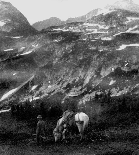
Descending from Cloudy Pass, Burr Singleton leading pack horse with wife.
1920, Singleton Family Collection
Burr frequently stopped southeast of the summit in the meadows of Grouse Creek, where he knew there would be ideal campsites, protected from prevailing winds and giving comparatively easy access to the upper mountain. Groves of whitebark pine and larch dot the meadow landscape, with their distinct shades of green bracketed by small streams—the headwaters of Grouse Creek. Beginning in July 1958, Burr was engaged in five attempts on the mountain, finally reaching the summit in June of 1960. For various reasons his first four tries were not fruitful; either the weather, the skill of the group, or their motivation was lacking. Even so, each trip gives a glimpse of Burr’s feelings for the area. [2]

Burr Singleton on the shoulder of Cardinal Mountain, whitebark pine snags.
1960, Singleton Family Collection
Cardinal . . . Not a really heroic project, but pure poetry certainly. This moose of a mountain reigns isolated from the foot of man, guarding the northern end of the Chelan Range. Still in white man’s time the home of the grizzly; lying between the Wild Bear Creek country and the beautiful North Fork of the Entiat . . . camp was a dream, in a saddle at the base of the Pyramid [Mtn.] overlooking Lake Chelan, deep in its blue and silver shadows . . .
In Burr’s first attempt on Cardinal his party nearly reached the summit, but they had inadequate climbing equipment for the rock pitch up the last gendarme, and wisely retreated. If anything, the trip appeared to have heightened his fascination with Cardinal and its surrounding high country. The following summer Burr made three more journeys to Cardinal, but each time they fell short of the summit. The first try was in July with ideal weather, camping at Burr’s favorite Grouse Creek basin. Again they came close to the summit, but lacked the skills and perhaps motivation, at least for the group as a whole. Three weeks later Burr returned with a new partner, on this attempt hiking up the North Fork Entiat trail to a different basin for their camp, lying just west of Cardinal. This is the identical campsite Burr and I used six years later on another climb of the peak—a delightful place with larch, meandering streams and an open view to the west toward Emerald and Saska Peaks. Cardinal towers to the north, creating with Emerald and Saska an arc of summits above park-like basins, each distinctive in setting, feeling, and isolation from the trail.
Cardinal from this basin is eye filling. That afternoon we went up the arete; took shots [photos]. The next morning, early, found us on the opposite side of the mountain in the head of Grouse Creek. Here goat were flushed. The pinnacles east of Bear Creek were eye filling.
But again, the party did not have the right mix of skills to master the last rock pitch. Burr tried again that fall with a third group, but the weather was too stormy. They reached no higher than the Grouse Creek camp. By now Cardinal had become the primary focus of his mountaineering energy, and perhaps more.
Late June of the following year brought a different result. Burr was nearly 80, so he needed a companion with some genuine rock climbing skills to give the party strength for the last 100 feet of steep rock. His Lake Chelan friend Don Avery was the individual able to give the necessary support.
By late afternoon camp was made at Grouse. Snow was encountered all the way to the summit. It being firm and with crampons, climbing was good; skies of blue! . . .Four feet of snow at foot of our favorite gendarme. Don climbed up the lead to the over-hang on the east face; a piton, a biner threaded, then a traverse to a narrow chimney that was filled with fragmented rock; then another piton and with a secure belay from the foot, Don was in the promised land. The top was flat, a few feet wide and of fragmented rock. And boy! What an eye full! A fog at four thousand feet blanketed the whole state; above the fog were—Rainier and Baker and all between . . . In a daze of happiness, the car twelve miles down the North Fork was reached by early twilight.
Cardinal was not the end of that summer’s efforts for Burr. During mid-September of the same year, Burr and a young friend spent over a week in the Railroad Creek and upper Stehekin valleys near Lake Chelan. Their first goal was Mt. Fernow, part of the 9,000-foot divide between the upper Entiat River and Railroad Creek. The area was south of the recently abandoned Holden Mine, and at the time of their visit was gradually being transformed into a busy retreat center. Burr’s companion was an energetic young man from Ephrata, Jim Wickwire, about 60 years Burr’s junior. In later years Jim gained stature as a world class climber, with first ascents on Rainier, other Cascade Peaks, as well as success on Himalayan giants like K2. But in 1960, Jim was only beginning to learn about mountaineering.
Their route up a steep trail lead to a campsite in spectacular Copper Basin, enclosed on three sides by Fernow, Buckskin Mountain, and the remainder of the high divide separating the Entiat country from the Railroad Creek watershed. Copper Pass, nearly 2000 feet above the basin, gave them a glimpse of the Entiat cirque, which had so impressed Cool and Rusk during their 1906 trip across the Entiat and Chelan ranges. It likewise affected Burr.
It was a lovely meadow, well watered, glaciers and towering crags hemming us in . . . Sunday dawned with disturbing overcast hiding the crags; two cols seem to give access into the Entiat Meadows. Nourishment attended, we set out for the col on the shoulder of Copper Creek . . . Jim and I got into the col overlooking the Entiat Meadows; these were lovely; above the meadows falling glaciers lay on the shoulders of Fernow—the top of which we never did see—it being enshrouded in the overcast; wind-driven sleet and snow sapped our ambition—we had no business on such an awesome and unknown country—we backed off, intending to return in the morning if the overcast cleared—which it did not. Back to camp without incident; nourishment followed. A big bear dropped around—social call; he was a cut-up, a show-off.
The next morning they shouldered their packs and headed toward Holden, rather than stay in camp another night and attempt Fernow the next day. The weather was still threatening, so they reasoned it was more prudent to give up any chance of climbing Fernow, and instead travel during inclement weather to the upper Stehekin, where they had other, equally exiting climbing plans. After reaching Holden, Burr was able to arrange a ride down the 10-mile road to Lucerne, where a Forest Service public dock and series of private cabins are located on the western shore of Lake Chelan. The following day Burr and Jim caught the passenger ferry “The Lady of the Lake” for the ninemile trip to Stehekin, and a chance to climb either Mt. Buckner or Logan, two worthy summits over 9,000 feet tall, on opposite shoulders of Park Creek Pass. By the next afternoon they arrived at the upper basin a half-mile short of the pass. Miss Wheeler had hiked over the same pass in late summer of 1932. Little had changed when Jim and Burr set up camp in the meadows just below the saddle.
Park Creek Pass is as eye filling as Buck [Creek Pass], but different; Buck is gracious and lush—Park Creek is gracious, still there is much of the fearsome—precipitous and savage peaks of rocks; the pass is filled (at summer’s end) with 6 feet of hard snow—a half-mile of it; the basin on the south is carpeted with heather, blue berry, grass, flower, and white bark pine, alpine fir and larch—holding the artistic soul spellbound; the basin is several miles across—guarded on the east by the brute Goode, the west by the picture-book Buckner, with its two broad and active glaciers; on the south stands Booker, a precipitous wall—its smaller hanging glaciers occasionally giving vent to thunderous ice falls.
Jim and Burr began their climb early the next morning. After spending nearly four hours working their way around crevasses of the Buckner Glacier and ascending a short arete, they found themselves under a very steep snow chute. The snow felt soft and unstable, and feeling uneasy about their predicament, Burr felt it unsafe to continue under the present conditions. Reluctantly, they retreated to camp, spending the afternoon relaxing in the beautiful upper basin of Park Creek. They spent a pleasant night with “sociable deer and grouse.”
The next day Burr and Jim scrambled up the shoulder of Mt. Logan, just north of Park Creek Pass, scouting the climbing route on Logan’s south side for another year. They climbed high enough for an expansive view: “What a country! Baker, Shuksan, the magic Primitive Area far into Canada. Marvelous country…”
Burr chose not to attempt a climb of Mt. Logan. Perhaps the previous two false starts had made him especially cautious, and reluctant to take a chance on yet another peak that could prove too formidable for their oddly matched two-person party. Instead, they simply enjoyed the setting of the upper Stehekin country. Burr never returned to climb either Buckner or Logan, but he did visit Park Creek and the upper Stehekin on a number of solo hiking trips to see the area’s autumn colors—brilliantly colored vine maple, cottonwood and Douglas maple.
In late August of 1963 Burr and I set out to climb Glacier Peak by way of the White River trail and the Whitechuck Glacier. The first day’s 14-mile hike to the Cascade divide (Little White Pass) was long and filled with bugs. Burr hiked steadily and at a pace where his energy would last the entire day. For the last mile to the crest the trail steepened, and I found myself hiking faster than Burr. After a half-hour’s hike I arrived at the pass and cached my pack. I walked back down the trail to meet Burr, and offered to carry his pack the last half-mile. He gladly accepted. I was pleased our relationship had evolved to where he would accept my help, without embarrassment on his part or mine.
We camped near my first stopping point. It was high, and breezy enough to be free of the pesky black flies that had bothered us for most of the day. The shelter of a large mountain hemlock protected us from a brief evening shower. Their needles can hold an amazing amount of rainfall before they begin to drip, and we were lucky the shower was short enough to be within that parameter. The next day was a much easier hike for Burr, only five miles along the crest, with over half of it on the gently graded Pacific Crest Trail. For the last few miles we walked along an old sheep trail heading north of White Pass (Chapter 11). By early afternoon we placed our base camp on a high ridge just south of Foam Creek basin, about a half-mile beyond the end of the sheep trail. The summer was nearing its end; grasses were mature and dark green, with late summer flowers at full bloom.
Daylight and nourishment cheered us on our way to White Pass and on to a high heather ridge, just under the pass leading onto Whitechuck Glacier, the route to Suiattle Glacier and the Peak. Nearly a whole day was spent here basking in the bright sun and in a most lovely setting . . . Always in our eyes, Glacier Peak, David . . . Sloan and the Monte Cristos—fabulous!! The bloom superb!! Some overcast hung about. Next a.m. early dawn, start was made for Whitechuck Glacier, and hopefully, the Peak. Four miles on the Whitechuck led us to the Suiattle Glacier and a clear shot at the beckoning White Peak. Embarrassing to utter, I here felt unequal to attaining the Summit and back by 7 p.m. After pictures, a little nourishment, and having drank deeply of scenery, we drifted back across the Whitechuck to the haven of the heather ridge and comforting camp. An afternoon of deep luxury.
By 7 p.m. dreadful to recall, began a terrific storm, here at 7,000 feet and on an exposed ridge. It continued thru the night til 9 next a.m. Rain, hail, snow, full gale, lightning, deafening thunder! Chet’s big plastic was spread over the equipment and we crawled in besides, tucking the border of plastic under us to keep all from blowing down the mountain; then holding onto the plastic for dear life, the night thru. What a thrill, if nightmare can be thrilling! The first apparent break, with packs on back, we drifted back the Crest Trail to Indian Creek and its 11 miles down to the comfort of the waiting car, where in a crashing deluge it received us at 5 p.m.
A year later Burr wrote again about this special campsite high above Foam Creek basin. “What a beautiful base on that heather ridge…in spite of the fizzled ascent our memories nurse priceless impressions—the grandest, I think, it has been my privilege to behold in the Cascades!” [4] I can understand Burr’s reaction; the area can have a deep effect on a person. The meadow areas around Foam Basin and south toward White Pass are indeed rich with pink and white heather, bistort, aster and other subalpine plants. But it is the contrast with the ice of the White River Glacier, Indian Head and Glacier Peak, which largely creates the area’s special character. Since the 1963 trip I have returned to Foam Creek three times, and on each occasion I have felt the uniqueness of the setting. The meadow-covered ridges and basins are compelling, filled with parkland plant communities and small streams. The forest edge drops off steeply into the White River valley, so that the meadow country seems suspended between the valley and the high peaks that surround the White River Glacier. During a summer storm these relationships appear exaggerated.
In 1972 Burr took a multi-day trip to what may have been his favorite mountain, the Stehekin Valley’s Mt. McGregor. Mc- Gregor is a characteristic Eastern Slope mountain, with small pocket glaciers on its northern flank, and sunny, rocky benches on its southwest slope. He hiked solo up the McGregor trail to a secluded bench where he had camped many times before. Pine grass covered the ground beneath scattered Douglas fir and ponderosa pine. In the 1950s and ‘60s the area was occasionally used as a bivouac by mountaineers intent on McGregor’s upper, steep snow pitches. At present it is rarely used, with hardly an indication of human impact. The grassy bench gives a broad view to the south toward Bonanza Peak, and toward the west looking up Agnes Creek at Dome and Agnes Peaks. Burr also liked the campsite because it would often be sunny and warm, while storm clouds would shroud much of the Cascade Crest to the west. But during this week in early October the skies were clear and autumn colors were at their peak.
. . . the Stehekin color is in a class of its own . . . was on the mountain two nights, bivouacking at that little bench you know, carried a quart of water mixed with a can of orange juice. That bench has great charm; grass a foot high . . . Between the nights I went on up, though finding the trail a struggle—was carrying about 25 lbs.—didn’t continue to top, turning back at 7,500 feet at noon; I wanted to take a lot of shots while the sun was high; next a.m. I took a lot on a leisurely descent to High Bridge.
The McGregor trip was Burr’s last journey where he would climb high on the shoulder of a mountain. That next summer he visited the upper Stehekin Valley for the last time, taking photographs from the valley floor, pleased to once again see and walk beneath McGregor and the other peaks of the Stehekin.
Chapter Eleven
Forgotten Sheep Trails
Forest Service maps of the 1930s, and even some as late as the early 1950s, indicated miles of remote, high mountain trails crossing passes and winding along ridges, where present maps show nothing but geographic features. These forgotten pathways passed through some of the region’s most beautiful high country—isolated ridges and basins set beneath high summits. Much of this system of trails, which has been abandoned now for decades, was a pattern of sheep trails that interconnected mountain meadows into a viable summer range for thousands of head of domestic sheep. Some of the routes were nothing more than broad driveways, now grown over and difficult to find, much less use. But other routes became distinct trails with recognizable tread, especially in the high country where the herders’ pack animals traveled the same path every year. Decades of use by herders, in some areas beginning before 1900, created an intricate series of routes, linking together high ridges with major valley trunk trails.
This pattern of grazing was widespread over much of the high country of the Eastern Slope of the North Cascades, even before the creation of the National Forest System. To a considerable degree, the perception by some elements of the public and press that overgrazing was occurring in the mountain west, was one of the compelling arguments supporting the creation of the Federal Forest Reserves, the predecessor of today’s system of National Forests. There were increasing pressures to protect the public interest by limiting grazing, and thereby reduce the threat of erosion and disastrous flooding in the populated, lower valleys. Early accounts described bands of enormous size. Fred G. Plummer, surveying forest conditions in the Cascades for the U.S. Department of the Interior in 1902, estimated 60,000 sheep were grazing the Entiat and Mad River watersheds. [1] Bands nearly as large grazed other parts of the Eastern Slope high country as well.
Although the original Forest Reserves were established by a presidential executive order in 1897 (the large Washington and Rainier Forest Reserves in Washington State were part of that order), it was not until 1908 that manageable administrative units were created, including the Wenatchee and Chelan National Forests. One of the earliest and highest priority goals of National Forest administration was the regulation and management of sheep grazing on the public lands. Individuals, groups and professional foresters had growing concerns over the health and continued viability of the grazing lands, and special worry about the effects of overgrazing on water runoff and overall watershed quality. In some cases grazing was even halted for a season, or longer, until the condition of a range could be evaluated; in many grazing areas limits were established on the total number of animals allowed during a season. During World War I this general trend toward more enlightened land stewardship began to conflict with the pressing demand for meat, so for a time, grazing lands felt the renewed stress of meeting war time needs. Following the Armistice of 1918, demand for sheep returned to normal levels, bringing about a political climate where rangeland management could improve once again.

Grazing in the Entiat Meadows.
1920, Wenatchee Valley Museum and Cultural Center
In the 1920s the size of bands continued to diminish as the Forest Service implemented more restrictive, but more sustainable grazing policies. Equally as important, the timing and pattern of grazing also changed. Entry into grazing areas was not permitted until that season’s grass was sufficiently mature to resist long-term damage. If entry was made too soon after early season growth began, the future health of native grasses could be jeopardized. In the early days it had been common for bands to enter an area as early as possible—when the first green was showing after snow melt—and stay in the latest ranges until the first snows of early autumn. The new pattern of grazing, emphasizing stewardship, also required that travel routes and campsites be clearly defined, reducing the effects on streams and wet areas, as well as areas with dry, easily eroded soils. The new management philosophy took time to implement, but by the 1930s a more stable—some advocates would argue nearly sustainable—program of range use had been developed. Specific areas had been identified, termed sheep and goat allotments, and each was evaluated in terms of the number of ewes it could support, either consecutively or on alternating years.
The historic allotments of much of the Cascade Eastern Slope were well placed geographically and climatically for grazing. Allotments in the Wenatchee and Entiat watersheds were used by herders based in Yakima and Ellensburg, and in the earliest days they trailed their animals to the lower hills around Leavenworth to take advantage of the springtime grass. In later years, when mechanized transportation became available, they were trucked to the same point. As the spring and summer progressed, higher elevation areas were grazed as the snow melted and grasses became available. The high meadows at the eastern extremity of the Cascades would be ready for sheep by late June or early July. After these areas were grazed, herders would move the bands farther westward, following the ridges and basins as the season’s vegetation matured to provide adequate forage. Weather helped make the allotments of the Cascade Eastern Slope popular with herders; there was much less rain and fog compared to areas west of the crest. Even a difference of several miles east of the Cascade Crest was significant during a three-month season of continuous camping.
One of the oldest sheep ranges on the Wenatchee National Forest was the Wildhorse allotment, where heavy grazing had occurred before 1907, prior to the establishment of national forests. W.E. Mudd of Ellensburg drove his bands into Meadow Creek, a major tributary of the Icicle River, grazing that area’s extensive meadows first, then moving onto nearby 6,600 Ridge for a short stay. His eventual goal was the enormous meadow areas of Frosty Pass and the upper Wildhorse Valley, including upper Mule and Brule Creeks. This is part of the same country that Hal Sylvester first visited in the fall of 1909, naming many of the streams and lakes (Chapter 2). Mudd’s bands of sheep would stay for up to a three-and-one-half month season, moving from meadow to meadow, fattening the lambs as the summer progressed. In 1916 up to 6,000 sheep grazed the Wildhorse allotment. Forest Service management began to reduce the total numbers allowed on the range, and by 1918, the number had lowered to 4,800. A reduction to 3,600 occurred in 1923, declining further to 1,100 in 1941. [2]
One of the more awkward administrative problems faced by the Forest Service was communication with herders. Many were Basque and spoke and read only Spanish. The language problem exacerbated the challenge for the agency’s field staff in explaining to herders the required routing plan for the sheep, their approved bedding areas, and other special instructions and restrictions. Spanish Camp Creek, which drains the Ladies Pass and Lake Florence area, is part of the allotment’s heritage from this interesting era. Even as late as the 1970s, a weathered Forest Service wooden sign marked “Spanish Camp”, a sheltered campsite east of Lake Florence where herders camped decades ago. With clumps of subalpine fir scattered across the meadow basin, “Spanish Camp” is a setting of considerable beauty. The rugged north face of Grindstone Mountain presents a stark contrast to the otherwise green, almost lush landscape surrounding the camp.
Today’s officially designated and maintained system of Forest Service trails is an assortment of varying origin, age, construction standard and style. Portions of the trails we travel today originated from herder use, pounded out of the ground as the bands were driven to their summer range in the high meadows. Wherever the terrain was steep, herders all too often chose a grade too severe for erosion control measures to be effective, although it did meet their requirement for an efficient route. In places like these, the Forest Service, in the 1930s and sometimes even earlier, improved and rebuilt eroded sections of trail to a gentler grade. Sometimes relocations would be miles long, and required a major effort by Civilian Conservation Corps and Forest Service crews. Trail improvement continued through later decades as well, leaving us with a curious variety of routes. Some are gently graded with contoured switchbacks, others are more direct and energetic in their approach. Other trails were simply abandoned because they were no longer needed, as some activities, especially herding, waned by mid-century.
Although many of the more remote sheep trails were abandoned, decades of use had left a mark. These old sheep trails, part of the heritage of the Cascade Eastern Slope, are some of the high country’s most interesting traveling. Unmaintained for years, they are recognizable today in many locations, and are usable to a degree by those willing to seek them out. Some of the routes, like the sheep trail heading west from Frosty Pass in the upper Wildhorse Valley, follow gentle meadow benches and are easy to walk, even today. They are frequently used by hunting groups in the fall, and by others who are looking for campsites distant from main trails, offering greater solitude.
However, some of the old sheep trails fall in a special category. They sometimes lead through hidden passes to grazing areas and secluded basins, long forgotten by most high country travelers. They are often difficult to follow, with meager treads appearing intermittently, requiring close attention to avoid loosing the route. Sometimes a person continues for a time on only wilderness intuition—a vague idea of where a logical route would lead. With perseverance one may come upon the old tread again, and continue the route of the herders and their pack animals of three-quarters of a century ago.
A complex and spectacular series of sheep trails, collectively known by the Forest Service as the Rock Creek Allotment, spanned much of the upper Chiwawa River country. In the earliest days it was considered three separate areas, or allotments, but before long they were merged into one for simpler administration; the three segments could be used as one large and diverse grazing area for an entire summer. It was a favorite of herders because of its favorable weather, good early and late forage and a long, continuous route requiring little backtracking.

Arduous Route of the Rock Creek Allotment
The route also included some of the Cascades’ most compelling landscapes, combining both dramatic and subtle elements. Like the Wildhorse area far to the south, the Rock Creek Allotment had been grazed extensively prior to the creation of the National Forests. The allotment was unusually large, extending from Rock Creek and Ice Creek Ridge, to as far as the luxuriant meadows of Middle Ridge and Small Creek just west of the Cascade divide. In between, the route passed through Spider Meadow, across the high meadows of Phelps Ridge, into the broad basin of the upper Chiwawa River below Chiwawa Mountain, eventually climbing a very steep route to the summit of Buck Creek Ridge. From that point the sheep traveled toward Pass No Pass, crossing Buck Creek Pass, and finally entering the meadows of Middle Ridge. At the end of the summer they returned to the Chiwawa road by way of the Buck Creek trail. In total, the loop from road to road was more than 50 miles, with 25 separate, designated campsites.
During the 1920s, when most of the range was utilized annually, from 3,500 to 4,800 ewes grazed the route at one time. By the 1930s grazing was often on a biennial basis, rotating with other allotments to the south. This practice reduced the impact on forage areas, and on the easily erodible, dry ridge-tops and steep slopes, where the travel routes often followed. Despite the steepness and rough condition of some of the trail sections and driveways, the herders were able to drive their bands from feed area to feed area without losing many lambs. Hiking through some of these areas now, their success is remarkable and reflects well on the skill of the herders and the quality of their dogs, so valuable in controlling a band’s movements.
In 1951, H. W. Elofson of the Forest Service (at one time Assistant Supervisor of the Wenatchee NF) inspected the first half of the range from lower Rock Creek to Leroy Creek basin. This portion of the allotment included the majority of the driest high elevation meadows, taking him through the sunny south-facing basins between Carne Mountain and Seven Fingered Jack—the remarkable Ice Creek Ridge country described in Chapter 1. He was seeing the effects of over 40 years of grazing, although sheep had not grazed the allotment the previous five years, allowing the meadows a helpful period of rest. Elofson noted that green fescue, one of the primary forage grasses, was vigorous and appeared to be in good health. Seed heads had formed, so he assumed adequate reproduction of grass was occurring. But he did notice one condition that plagued the steeper sections of most of the sheep trails: the Leroy Creek trail was in poor condition. It was rutted, multi-trailed, and showed a disturbing amount of soil erosion and loss of vegetation. This was a common characteristic of steep sheep trails, especially when the soils were rocky, dry or composed of pumice. The steepest parts of the Leroy Creek trail have changed little since 1951, except for perhaps the recovery of additional vegetation where Elofson saw only bare soil. These routes rarely had water bars to divert spring melt water, so even though the bands of sheep have left, in many cases flowing water has continued to create erosional gullies, especially where vegetation has not fully reclaimed the sides of the old trails and driveways.
Hiking the route of the Rock Creek Allotment today, one can have an experience rich in a sense of history, and rewarding in the variety and beauty of the mountain environment. The route has contrasts in both landscape and social setting, with some of the most lonesome, and some of the most frequently visited locations in the Cascade Eastern Slope. The first 11 miles of the allotment follow the Rock Creek drainage and much of the present day Rock Creek trail. The sheep driveway crosses the hiking trail several times during the first few miles, but farther up the valley the two paths become a single route. The first of the grazing meadows begins about seven miles beyond the trailhead, just west of the high ridge dividing Rock Creek from the Larch Lake basin. Three camps were used over the next two miles of alternating meadows—Lower Rock, Upper Rock and Allen Camp. The trail occasionally fades as it passes through flat, grassy meadows, a certain sign that upper Rock Creek has become increasingly wild over the decades—in comparison to the era of frequent sheep use. Limited travel by horses and hikers has allowed the grasses to cover portions of the trail. Each summer these were the first high mountain meadows to become ready for grazing. Because they lie so many miles east of the Cascade Crest, winter snowfall is usually moderate, and May and June are often dry and warm, bringing an early but short-lived lushness to the meadows.
The last mile of the Rock Creek trail switchbacks across grassy slopes and between rock ribs, before it intersects an abandoned trail heading along the south side of Ice Creek Ridge. This interesting sheep trail has not been shown on maps of the last few decades, but was included in maps during the 1940s and ‘50s. In places the tread is easy to follow, especially for the first mile and one-half, as it threads its way through larch groves and meadows toward the upper basins of Box Creek. At times false trails lead toward secondary meadows and basins where sheep once grazed. Trying to determine which path was the primary route can challenge the best trail sense. Sometimes finding the main route is more a measure of luck; all too often the most likely appearing tread is a false lead. Heavy deer traffic can make an old trail well worn, even though it was not the original, primary sheep route.
The upper basins of Box Creek face to the southwest, toward Glacier Peak, Buck Mountain and the glaciers of the Tenpeak Range. Even though the meadows of Box Creek are at a high elevation, their exposure and distance from the Cascade Crest help maintain their comparatively dry character. Their grasses and other plants are mature and dried by mid-August, with the exception of areas adjacent to year round streams or sunprotected wetlands. The smallest streams are often dry by late summer, unless the season has been unusually cool, slowing melting of the winter’s snowpack. This is what made the area so appealing to the herders—the meadows were bare of snow early in the year and the camping was pleasant. Those qualities are still a pleasure. Looking at these high basins today, it is not clear to what extent the many decades of sheep grazing may have altered the pattern of vegetation, changing either the species composition or the density of grasses and other plants. We can assume the effects of the unregulated, early days of grazing were noticeable. They were clearly a major concern, for otherwise, the newly established Forest Service would not have been so adamant in reducing the total number of grazing animals and altering their pattern of movement. But walking through these basins in our era, it is impossible for the lay observer—or perhaps anyone—to know with reasonable certainty which erosional effects are intrinsic to the landscape and which were induced.
Regardless of the precise history behind the pattern of vegetative change, the high basins along Ice Creek Ridge remain a place of beauty. The contrast between dry meadow areas and narrow, lush creek-side bands is less pronounced in early summer, but becomes striking as late summer arrives, when only narrow ribbons of stream-watered vegetation are freshly green and flowering. All else is muted, losing the luster of the growth cycle, with the grasses and sedges taking on tans and light golden hues of the summer’s end. The contrast between wet and dry is even more evident if early fall remains warm and sunny—an Indian Summer— as it does perhaps one out of every three years.
The sheep trail fades as it leaves the North Fork of Box Creek, but then begins to reappear as it skirts below Ice Creek Ridge near Chipmunk Creek. Chipmunk basin and both forks of Box Creek were typical sheep camps, with multiple trails leading in several directions where the bands would alternately graze. The paths then vanish as the bands dispersed looking for the best grass. Where travel routes were more limited by topography, the trail is often well preserved. The descent from Chipmunk Pass into the east fork of Leroy Creek follows this pattern. It is surprisingly easy to recognize and follow. Here one can be nearly certain of walking on the original, historic trail. The steep switchbacks are still well defined with good tread, as if one had suddenly stepped onto a maintained trail. The herders’ pack mules had followed the exact path season after season, while the sheep may have dispersed over a greater area.
A short hike beyond the last switchbacks the trail fades again for nearly a half-mile, then resumes where a band of forest is reached on the eastern boundary of Leroy Basin. Rock and soil debris sliding off the steep slopes of Mt. Maude have covered and altered the surface, obliterating the original trail. Over the last few decades deer trails and hiker scramble paths have developed, meeting and diverging several times until reaching the forest edge, where they combine and eventually traverse into the basin. Leroy Basin was the last of the high camps used by herders on the Ice Creek Ridge segment of the summer-long sheep route. Although not the largest of the meadows along the ridge, it may have been one of their favorite camps. The basin is a perfectly composed setting: a year-around stream meanders through the meadow from a spring near the center of the basin, and monarch larch rim its lower edge. Mt. Maude and Seven Fingered Jack, the highest summits of the Entiat Mountains, rise 3,000 feet above its floor.
The trail leaves Leroy Basin through small meadows, then descends steeply for several thousand feet toward the Phelps Creek Valley. This part of the route, which is steep and eroded, is heavily traveled today by hikers and mountaineers. It is scuffed by hundreds of Vibram-soled boots, rather than thousands of sheep. Many are headed for either Mt. Maude or Seven Fingered Jack; others are hiking toward the Ice Lakes, two isolated lakes just east of the crest of Ice Creek Ridge. Cool and Rusk led their two pack horses over a rocky pass, the only possible access from the Chiwawa drainage, and camped at the lakes in 1906 (Chapter 7).
After joining the Phelps Creek trail, herders trailed their bands up the valley several miles to the expanse of Spider Meadow, now one of the most popular hiking destinations in the Wenatchee National Forest. After grazing in the mile-long meadow, the sheep were backtracked one and one-half miles to where the Phelps Ridge trail (now abandoned) left the main valley and began a severe climb through a dark and dense stand of Pacific silver fir. The herders’ success in safely leading their pack animals through this section of trail says much about their skill and patience, and especially the quality of their pack animals. The path eventually climbs into a high basin below the crest of Phelps Ridge. Sections of tread are still visible during much of the climb, but completely disappear in the open meadow below the last climb to the ridge-top. Even before reaching this point, young larch and subalpine fir are growing in the old tread in places, obscuring what otherwise would be a more visible trail. The shape of the tread begins to reappear 50 yards short of the ridge-top, a faint platform indented into the sod, although fully covered with vegetation. In some ways it is easier to feel the trail with your feet than see it, because of the thickness and height of the grasses that have re-seeded and grown since the days of heavy sheep use.

Fortress and Chiwawa Mountains from Phelps Ridge.
The trail is unmistakable where it crosses the low saddle of Phelps Ridge. To the west and southwest, scattered larch and subalpine fir frame views of Glacier Peak and the Tenpeak Range. Toward the northwest, Fortress and Chiwawa Mountains create a graphic backdrop for the large meadows 1,500 feet below, sheltered at the head of Chiwawa Basin. This distinctive pass is mid-way between the high, dry meadows of Ice Creek Ridge, and the moist country surrounding Buck Creek Pass. An old sheep camp was located about 400 feet below the saddle on a protected, green bench, with water available and meadow slopes nearby for grazing. From here the route traversed a series of basins and parklands until nearly reaching the rocky apron of Red Mountain, the last camp until dropping to the lush meadows of Chiwawa Basin. The basin supports more moisture-loving plants than the slopes of Phelps Ridge, but both types of habitats were suitable for grazing by the opportunistic foragers. As with other sheep allotments, the bands of sheep utilized a variety of plants along their summer-long route: green fescue grass, dry and meadow sedges, non-grassy herbs such as bluebells, cow parsnip, valerian and others. The more tender leaves of common shrubs were also part of their diet.
The herders used three separate camps in the upper Chiwawa River area, but eventually had to face a steep, challenging route the equal of the difficult Phelps Ridge ascent—the climb to the high divide west of Massie Lake, giving access to the meadows along Buck Creek Ridge. This series of benches and grassy slopes ended at Pass No Pass, and included the largest continuous series of meadows along the route. The views across Buck Creek to Buck Mountain, Glacier Peak and the summits near High Pass are equal to any in the Cascades. Like other parts of the route, the trail appears and disappears several times, eventually becoming more distinct as it nears the basin adjacent to Pass No Pass, lying directly below the slopes of Fortress Mountain (Pass No Pass and Fortress were named by Sylvester in 1908). In the autumn the larch trees, huckleberry and Cascade azalea create a complex pattern of color. The smell of ripe huckleberry is a certain sign that summer has ended. Only a short autumn period buffers the high country from the first substantial snows of the approaching winter.
Buck Creek Pass is only a mile west of Pass No Pass, and covers a considerable acreage, for a Cascade pass. Its lush parkland creates a striking foreground for the ice and rock of Glacier Peak and the Tenpeak Range that so dominate the distant scene. In the earliest days the area was heavily grazed, but by 1921 the pass, proper, was closed to grazing because of conflicts with horse groups and hikers. Although it was common for both groups to express some disapproval over the dusty trails and odors caused by grazing bands of sheep, the Buck Creek Pass closure appears to have focused largely on preserving adequate feed for the horses and mules of recreation parties. That this took place in 1921 suggests that the grand parkland around the pass, even in the early days of the Forest Service, was valued beyond solely commodity production. It may also have been relevant that Sylvester, Supervisor of the Wenatchee Forest at the time, considered the area around the pass the most scenic location in the Cascades, and hence deserving of an extra measure of early day’s land stewardship.

Seven Fingered Jack (left) and Mount Maude
from above Massie Lake.
The closure did allow sheep to be herded through the pass as they traveled to their next feeding areas, but they were not to be bedded down or graze for any length of time. Their travel path was slightly above the elevation of the pass, on the lower shoulder of Helmet Butte. At times the band would spill over onto the main trail near the pass, resulting in some trampling and grazing of the vegetation. While the effects were immediately noticeable, after some rain showers and a few weeks of rejuvenation, the overall impact was reduced, even though measurable. Sheep were still moving through the pass as late as 1965 when I hiked into the area, and I could not help but notice the effects of sheep recently traveling near the trail. At the time I was put off by the practice, but I must admit the history of grazing, the legacy of their high country routes—the era that was the first four decades of the 20th century in this part of the Cascades—has remained fascinating to me.
The last large meadows of the allotment extended across the west shoulder of Fortress Mountain, a mile west of the Cascade divide in Small Creek basin and at the top of Middle Ridge. Both areas have spectacular settings, especially when looking toward Glacier Peak and the Suiattle Glacier—and the grazing was excellent. The only disadvantage for herders was the area’s tendency for fog and rain, at least in comparison to the previous two and one-half months of grazing the more storm-protected portions of the Rock Creek Allotment. After finishing their stay at Middle Ridge, the sheep were brought back through the pass and driven the next three to four days down the original Buck Creek trail, feeding on the meadows of the upper valley. Because of major trail relocations finished in the early 1980s, the Buck Creek trail today traverses above much of the upper valley and its acres of green meadows. The new trail crosses a slope of mixed huckleberry and subalpine fir, open enough for a clear view of the grazing areas. Most of the meadows in the upper valley are at the bottom of large avalanche paths, so the deep green of their grasses and sedges climb up the mountainside like enormous fingers, separated by narrow bands of trees where the avalanches are diverted by minor ridges.
Along the lower half of the Buck Creek valley, the old route is bypassed in several sections by 1960s era trail relocations, avoiding the steepest sections of the original sheep driveway. In places, one can see the contours of the broad driveway, now partly obscured by alder and down trees, but still visible. These sections of the driveway are a pleasure to walk, even with windfalls slowing the pace slightly. The ground is no longer dusty from sheep travel, but needle covered and soft. Walking there rewards one with a feeling of solitude and a sense of history
Many other old routes are fading away that are equally engaging to rediscover. Not all have a landscape as diverse as the Rock Creek Allotment, but all require long days of hiking to fully appreciate what is there. One interesting route follows westward from Poe Mountain along Wenatchee Ridge. The ridge is richly green with steep meadow slopes and several hidden basins, all covered with ripening huckleberries in the fall. Like other sheep routes, it is easy to follow in some segments; in other places the trail is simply gone—it no longer exists. When this happens, the best strategy in finding the trail again is to continue moving, thinking as much like a herder as possible, walking a reasonable yet grassy route, realizing that the greatest amount of forage per mile was probably their objective. The Wenatchee Ridge trail is never too far below the ridge crest, dipping to a low point as it traverses below Longfellow Mountain. As the trail approaches the Cascade Crest near Kodak Peak, the terrain becomes gentler, covered with a dense, green mantle of huckleberry, heather and grasses.
The region along the Cascade Crest north of Kodak Peak—Indian Pass, Indian Head and White Pass— is a richly green, high mountain parkland. In 1966 I was hiking north on the Pacific Crest Trail toward White Pass, planning to use Foam Basin as a base camp for climbing Glacier Peak. The meadow country surrounding Indian Head seemed enormous, especially in conjunction with the parkland at White Pass and in nearby Foam Creek. We left the official trail north of White Pass, and began contouring toward Foam Basin on an unmarked, but quite distinct trail. Rounding a large meadow ridge, I began to understand what kind of trail we were hiking—over a thousand sheep were grazing above and below the trail. We continued walking, although more slowly, and as we reached the edge of the band, the herder gave us a friendly wave and motioned us to continue. His gentle animals parted as we approached and immediately closed as we passed the flock. The trail continued for over a mile, but began to fade as we entered Foam Basin, presumably the end of the route for that portion of the grazing pattern. I did not know it at the time, but the summer of 1966 was one of the last grazing seasons for the White Pass Allotment.
Thirty years later the trail exists in much the same condition as during the period of active sheep grazing. At that elevation there are few shrubs growing tall enough to obscure the trail, although a few subalpine fir are beginning to encroach from both sides of the tread. At their slow rate of growth, young trees can extend their limbs only a few inches each growing season. Use of the trail by deer traversing the basin, and climbers on the southern approach to Glacier Peak, are both helping to maintain its existence, and by so doing are sustaining what may be the most intriguing legacy of sheep grazing in the high country.
Chapter Twelve
On Skis and Snowshoes
Skis Through the Pasayten–Dale K. Allen in the 1940s
In the 1930s and ‘40s, extended winter journeys into the Cascade backcountry were most often ventures by trappers or miners. Ever since the 1890s, and extending into the 1950s, trappers snowshoed and skied up and down Cascade valleys in search of furs, solitude and no doubt adventure. Sometimes they built small cabins along their trap lines for shelter, using a well-stocked main cabin as their base. Miners tended to be cabin bound in comparison to trappers, if they even chose to stay the full winter at their claim. Both groups commonly lived alone or in isolation with a partner, apart from the dominant culture, living as independent a life as possible. Even though we can assume individual trappers and miners experienced considerable pleasure from living in a mountain environment in the winter, it is unlikely most were principally seeking what we would describe today as a “wilderness experience.”
Dale Allen was from a different mold. The essential reasons for Dale traveling through the Cascades in winter were his love of wilderness skiing and the exhilaration he felt while experiencing the high country enveloped in snow. He was fascinated with the wintertime wildland experience and the joy of skiing remote powder slopes. The 1930s, ‘40s and ‘50s were his most active decades, when many of his longest trips were during January or February. Images and impressions of mid-winter were special for him—it was quiet, austere, and yet filled with interest. It was not that Dale did not spend long periods in the backcountry in summer or fall, but compared to other seasons, the beauty he saw during winter was at a simpler and more elemental level. There were fewer sounds, so one could attend more closely to what remained—the sound of wind working its way through a forest, or the muffled sound of a creek flowing between walls of snow. Many animals were either hibernating or had migrated to a more benign habitat until spring, but some remained. Marten, lynx and rabbits were the major species easily detected in the Pasayten, and Dale never tired of interpreting animal tracks in the snow. During days of infrequent snowfall, when animal tracks remained undisturbed and hence cumulative, patterns could become complex.
Dale found winter an absorbing environment, especially while traveling on skis. His frequent skiing companion was Walt Anderson, a man of small physical stature but extremely fit and determined. He was skilled at skiing, winter travel and survival, and above all, philosophically compatible with Dale. While not physically imposing, Dale was larger than Walt and amazingly robust and motivated. Dale’s wilderness skills were unsurpassed. Much of his youth had been spent snowshoeing and trapping in the upper Lake Wenatchee country, so he was at home in a remote, wintertime environment.
Although most of their journeys were undertaken for the pleasures of wilderness travel, on occasion they were also seeking illegal trappers. Walt was a career state game department official after the early 1930s, and Dale’s career alternated between the game department and the U.S. Forest Service. Their mode of travel clearly reflected their definition of pleasure. Above all, they were committed to traveling light, without the burden of a heavy pack. By carrying as little as possible, they would be able to ski a maximum number of miles in a day, should the desire or need arise. To achieve that end, they sacrificed what many might consider important personal comforts, but to Dale and Walt they were not significant sacrifices, if good skiing resulted.

Dale K. Allen (at left) and companion above Lake Josephine, Chiwaukum Mountains.
1950, Robert W. Woods Collection
For a week-long ski tour, their packs were usually no more than 20 to 25 pounds. To the typical multi-day backcountry skier of today, this may seem unbelievably light. Even though modern fabrics and equipment are much lighter and more effective than what Dale used, his total pack weight was considerably less than what I carry today. The answer to this puzzle lies in understanding how they traveled and camped, and what they considered unnecessary. Dale and Walt carried no tent or sleeping pad. When a Forest Service or Game Department cabin was not available at day’s end, they would dig a trench in the snow, line the bottom with fir boughs, bridging the top with the longest boughs. Both the snow and boughs would help insulate them from the colder air. This style of camping is prohibited by wilderness ethics today, but in the 1940s it was a respected and skillful manner of winter camping. And it was light. A fourpound down bag provided marginal, but evidently sufficient warmth, unless they faced sub zero weather. Everything else was 100% wool, including their long underwear. A medium sized cruising axe was attached to Dale’s pack, essential for cutting tree boughs for bedding and shelter, and splitting wood for a fire.
Their food was limited in variety and quantity: hardtack, flour, dry pea soup, dried beans, raisins and oatmeal were standard fare. They also used miscellaneous food left by Forest Service crews, hunters, miners and others from the previous fall, which they could usually find in cabins scattered throughout the Pasayten country. In the 1930s and 40s primitive cabins could be found throughout much of the high country, and provided the winter traveler with a welcome haven. Dale and Walt were willing to ski up to 20 miles or more in a day, so that their camp could be a cabin. They wouldn’t make an extraordinary effort to do so, or take unnecessary risks, but, because of their rapid, light mode of travel, days of that length could be done without unwise risk-taking. To a degree they were able to carry marginal rations because they could expect to find supplementary food at almost any of the cabins.

The Pasayten landscape of Dale Allen’s Ski Tours
In early February of 1942 they began a nine-day ski trip through the central Pasayten country, an extended tour traversing a major portion of the present day Pasayten Wilderness. On their first day they skied up the Harts Pass road toward the summit, but experienced difficulty finding the right wax for the new snow that had fallen. Their destination for that evening was a snug cabin not far from Harts Pass, but their goal was eluding them as evening approached. Dale’s written trip account continues: [1]
It got late and still no cabin. It got dark and finally we got tired of the packs. They were too heavy and we decided to lighten them. We found a big tree to lean against and noticed a pitchy scar. This pitch furnished fuel for a quick fire. Two cups of chicken bouillon apiece and the packs felt better. An hour’s rest was needed most of all.
Stopping when tired, resting and recovering some, then continuing, was a common practice for Walt and Dale. Their philosophy was to never drive themselves near their physical limit, but as Dale would say, “to travel at ease at all time.” This didn’t mean, however, that Dale and Walt wouldn’t ski a great distance in a single day, but even a very long day was undertaken within well understood limits and paced accordingly.
After shouldering their packs and skiing for no more than ten minutes, they were surprised, and somewhat chagrined, when they spotted their cabin. It was new, constructed the summer before by Forest Service and Soil Conservation Service crews as an aid in measuring snow depths during the winter and spring at Harts Pass. Cabins like these were always left unlocked, with fuel, food, cooking utensils and possibly bedding on hand, awaiting any weary, winter ski touring party. The next day Dale measured the snow stake: 64 inches, typical for a site in the Pasayten.
After spending several days enjoying powder skiing in nearby basins, Dale and Walt broke camp very early in the morning and began climbing toward a divide north and west of Harts Pass. The route would carry them toward the West Fork of the Pasayten River, the next leg of their extended ski tour. Their second camp, the Three Forks Cabin, was nearly 20 miles distant. Descending from the slopes of Windy Pass just east of Tamarack Peak, they skied through challenging terrain, eventually reaching more gentle and relaxing skiing near the West Fork Pasayten River. Because they had eaten only a light breakfast, Dale and Walt stopped under a massive spruce tree for lunch, cooking a gallon of concentrated pea soup, supplemented with some hardtack. The rest and nourishment bolstered their spirits considerably.
Snow had not fallen for a week, making ideal conditions for efficient traveling on skis. The well preserved snow surface also meant that a week’s worth of animal tracks were clearly visible. Tracks were everywhere. “Marten tracks were numerous. We saw several fox tracks, a few lynx tracks and some bobcat.” Just before dark (February days are short), they reached the Three Forks Cabin, located just north of the confluence of Rock Creek and the Middle and West Forks of the Pasayten River. They were tired after the long day, but very pleased with what they found: the luxury of a cook stove, an abundance of wood, and best of all, dried beans. The beans were a treat. “Besides beans for supper and breakfast, we carried some along in a coffee can, already cooked for the next evening meal.”

Dale K. Allen spring ski touring near Trinity.
1950, Robert W. Woods Collection
On February 6th they skied at a leisurely pace to the U.S. Forest Service Pasayten Guard Station, less than three miles south of the Canadian border. Marten, ermine and rabbit tracks were everywhere, and shortly before reaching the cabin, Dale caught a glimpse of a river otter in one of the side streams. In open areas the snow was no more than a foot deep, and with their dense boughs catching most of the snowfall, there was little more than a trace beneath the big Engelmann spruce near the cabin. Although this cabin did not have beans, it was well stocked with oatmeal, giving the pair a supplementary diet of mush.
The next morning they began skiing the route to Hidden Lakes and the Ptarmigan cabin, but found the snow conditions changing rapidly. The excellent traveling conditions of the earlier part of the trip had been replaced by especially challenging snow, caused largely by warming temperatures.
The surface snow was wet and we, of course, had to wax for it. Under this wet snow was a breakable crust. It would hold your weight on the two skis, but when you stepped forward the rear ski broke through. Under the crust was very loose dry snow. This stuck to the skis and really made them heavy.
Skiing was difficult, but by early afternoon they arrived at a Forest Service lean-to-shelter near Big Hidden Lake, and heated a welcome pot of vegetable bouillon for a short rest and energy boost. Their route led them from the shelter, along the east edge of Big Hidden Lake and part of Middle Hidden Lake, toward the Ptarmigan Cabin. Skiing continued to be difficult due to the unusual snow conditions, but the cabin, which lay near the confluence of Ptarmigan Creek and the Lost River, was reached before nightfall. Always resourceful, Dale prepared some very filling pancakes out of flour and maple syrup he discovered tucked away in a kitchen shelf.
The next day, February 8, was a long one, with the two friends skiing over 18 miles to a campsite near Eightmile Pass. During the day they had seen fresh goat tracks at the head of the Lost River, mink tracks on the frozen snow covering Cougar Lake, and fresh cougar tracks in Drake Creek, a main tributary of the Lost River. The big cat had come down from Eightmile Pass and tried to climb up the Drake Creek drainage.
In several places he had tried to climb up over a snowbank, but he was so heavy and the snow so loose that he fell back. He would then back-track a hundred yards and try again elsewhere. Finally he gave up and apparently went up the Lost River.
Earlier in the winter an intense snow storm had affected the Eightmile Pass area, with 20-foot-tall trees bent over with wet snow, forming arches of various sizes. Smaller trees had been completely covered, and looked “like a group of youngsters who had been covered for the night but did not intend to sleep.”

Dale K. Allen (left) at Trinity Mine, Chiwawa River.
Companions Wildfred Woods and Bill Barnet.
1950, Rober W. Woods Collection
The next day and one-half were spent skiing over snow-covered roads to the small town of Winthrop, where they shared a celebratory meal. Along the way they had but one crisis, a broken metal ski edge repaired en-route. Dale and Walt traveled this route more than once over the years, naming it the “Pasayten trip”, because the central part of the tour passed through the Pasayten River drainage.
Their journey had many moments of pleasure and relaxation, but there were more difficult and demanding segments of the trip as well, when perseverance was absolutely required. Asked why he did extended ski tours like the “Pasayten trip” Dale answered, “For the simple pleasure of going. Just being out in nature. Of course, you have to have the spirit for it, you have to want to do it.” [2] Reflecting on the effort, determination and patience needed, Dale added: “For many people these trips would be work, but for Walt and me it was a pleasure. There is the beauty of the country, the animal tracks, just being out there. At times it can be windy, cold and you can be hungry, but at other times you have ideal conditions. Then it’s just wonderful.” After a long pause Dale made a final comment: “I’m not sure exactly what being in the mountains does to you, but it does something, and it’s wonderful.” His answer was honest, direct, and completely open-ended.
East of the “Pasayten trip” was an equally long ski trek that Dale and Walt named the “Ashnola”. Over the years it remained their favorite, largely because it included so much terrain ideal for telemark skiing in soft snow conditions. This was especially true of the parkland near Spanish Camp, high rolling country with a backdrop of rugged peaks, notably Remmel Mountain and the Cathedral Peaks. During their lives they were able to take this 10-day journey three times. The following narrative is based on Dale’s recollection, made in the early 1980s, of their first “Ashnola” trip. [3]
It began at the Eightmile ranch, the last residence up the Chewuck River and the end of the plowed road during the 1940s. Their first day was spent skiing the remainder of the snow-covered road, arriving at the Lake Creek forest camp for that evening’s rest. The next day they climbed up the Lake Creek drainage toward Black Lake, skied across the frozen lake, and camped in the forest near the lake edge. Traveling had been slow because of deep, soft snow, making it necessary for the pair to trade places frequently while breaking trail.
Black Lake is surrounded by dense forest, giving their camp natural protection and ample firewood for a good evening fire. The weather pattern was colder than normal, with temperatures considerably below zero each night. Nights became colder as their trip progressed, making a good fire more important than ever. Their third camp was made at Fawn Lake just south of Ashnola Pass. It was now so cold they were compelled to adopt an unusual technique for keeping warm at night, placing one down sleeping bag inside the other. One person would sleep at a time, while the second would tend the fire. With the long nights of early February, even a half-night’s sleep was sufficient rest, especially if one could remain warm and sleep soundly. Their system made that possible. After breaking camp in the morning, Dale and Walt skied northward down Spotted Creek, and entered the magnificent Spanish Camp country.
Camp was established on Spanish Camp Creek, just a mile east of Bald Mountain, and adjacent to the areas’ rolling parkland. With continuing cold temperatures the snow was unusually dry, giving them the most enjoyable skiing of the trip, and on slopes not far from camp. They experienced powder telemark skiing at its finest, skiing run after run until the best terrain was covered with graceful arcs.
Their route out of the Spanish Camp basin took them north and east, past the Upper Cathedral Lake and through Cathedral Pass, shadowed by the steep granite masses of Amphitheater Mountain and Cathedral Peak. The pass itself was cold, where a brisk wind was filtered only slightly by the needleless larch trees. A comfortable night was spent four miles east of the pass at the Tungsten Mine cabin. Temperatures continued cold the next day, as Dale and Walt traversed along Bauerman Ridge through miles of silver snags from a wildfire that had burned over a decade earlier. The present day Boundary Trail follows their ski route quite closely (today only remnants remain of the once extensive silver forest). During the day Dale suffered from an annoying nosebleed, and because of the extreme cold some of the blood froze along his face. Eventually the cold temperatures helped to stop his bleeding.
Their second to last camp was made in a sheltered basin just east of Bauerman Ridge, with plentiful firewood for their evening fire from the snags near camp. The following day conditions remained clear and cold, which at least simplified the waxing of their skis, and to Dale’s relief, his nose was no longer a problem. For their last night they dug into the snow on the north side of Windy Peak, using the insulating snow of their cave to help them remain reasonably comfortable. For their last day they planned a long trek all the way to the town of Loomis. The two friends skied into the Loomis gas station at 9 p.m. and learned that the previous night the temperature in town had dropped to minus 30 degrees F.
The Pasayten Wilderness—early April 1998
Listening to Dale Allen reminisce about his Pasayten ski tours stimulated my own desire to ski some of the same powder bowls and traverse the same passes. For years other trips had taken precedence, and for good reason. Trips into the Pasayten can be logistically complex and approaches tend to be long. Most of the trailheads are many miles up snow-covered roads, adding several days travel time to a visit of the more remote high country. The most interesting loops involve a week-long tour at minimum, requiring a partner interested in the physical and mental challenge of an extended outing.
Key elements for a Pasayten journey came together in the spring of 1998, including the random factor of a period of cool, clear weather. I arranged for two residents of the Chewuck Valley to give us a snowmobile ride to the Billy Goat trailhead at the end of the Eightmile road. Their help enabled us to begin at a comparatively high elevation, and saved a day of ski travel and the weight of a day’s rations. Billy Goat Pass, and the Eightmile Valley east of the pass, was the exit route for Dale Allen’s February 1942 “Pasayten” trip; it is slightly west of the beginning of his “Ashnola” trip. Geographically, my companion Rob and I would be seeing portions of both of Dale’s tours, although our trip would be slightly shorter than either.

Open, fire-altered landscape near Three Fools Pass.
The climb on skis from the trailhead to Billy Goat Pass was short, less than three hours, but it gave us an exceptional view toward Big Craggy and Eightmile Mountain, and even into nearby Eightmile Pass, the beginning of the summer trail into the Hidden Lakes. Considerable snow had fallen the previous week and the weather had continued cool, giving the summits a glistening and snow-fluted appearance of mid-winter—severe and cold, but also dazzling. We felt a deep satisfaction in enjoying even one day like this, with the textures and shades of sun and shadow, on snow, rock and trees.
The pass was shaded by mid-afternoon, chilling us slightly when we stopped to remove our climbing skins. Before doing anything else, we reached into our packs for shell jackets to reduce the loss of any more body heat while we packed away our skins. In a few minutes we were comfortable again, especially so after we began the descent toward the evening’s camp along Drake Creek. Skiing was pleasurable on powder snow, weaving between islands of spruce and larch, the deep green of the spruce offsetting the bare outline of larch trees. Soon we dropped into an open basin and crossed the runout zone of an avalanche path. Quite clearly, it had seen an active season. Irregular mounds of snow and limbs scattered about gave us a singular message—it had been a winter of large avalanches. The basin floor was covered with snow debris and littered with wood: limbs from mature larch trees, and even the main stems of young spruce and larch. Young trees had been growing along the edges of the avalanche path, and several decades must have passed since an avalanche of this scale had enveloped the full width of the path, carrying live trees with it. Wind blast at the bottom of the runout zone had torn limbs off trees standing a short distance beyond the mass of snow debris. Rob and I were impressed by the effects of the avalanche that had so powerfully dropped onto the valley floor, a force we hoped to never experience directly.
Week-old cat tracks, either lynx or bobcat (they were too old to determine with certainty) nearly paralleled our route over Billy Goat Pass, heading in the direction we were planning to camp. We found a pleasant setting next to an open section of creek, right where the cat tracks crossed the creek. A grove of young spruce and a large, unusually broad-limbed lodgepole pine sheltered our tent from any wind that might develop during the night. Clear and cold conditions continued into the morning, strengthening a snow crust that had been forming on south and west-facing slopes. We were delighted at this. The crust made for fast traveling the next morning, as Rob and I quickly traversed on a gradual descent, and then began a gentle climb toward Three Fools Pass, pleased, and a little surprised, at how many miles we had covered in so short a time. Our energy level would be very different by late afternoon.
The south side of Three Fools Pass is quite open with widely separated Douglas fir and lodgepole pine. The place has a feeling of spaciousness, even though the ridges on either side rise abruptly. The trees are roughly the same age, a clue to understanding the area’s history. We were seeing the effects of a 1914 fire that had burned much of the Drake Creek area. Sylvester passed through Three Fools during his 1932 pack trip (see Chapter 5), and remarked how young trees were already beginning to reclaim burned areas. Even after eight decades of regrowth, we could see significant effects from the fire. The most obvious are occasional silvered snags and the open character of the forest. Rob and I enjoyed the distant, open view toward Billy Goat Peak, framed by a-half-dozen trees. Unlike many burned areas in the Pasayten, this part of the Drake Creek Fire has not developed into a dense lodgepole pine forest.
As we skied from the pass into the Diamond Creek drainage, we entered a dense, mature lodgepole and spruce forest. The snow was week-old powder, protected from the sun by its northwest aspect and shade from the forest. Its softness made controlling our speed easy—an effortless glide toward the valley bottom. Rabbit tracks were numerous and seemed to be running in every direction, but quickly dropped off as we reached the opposite side of Diamond Creek, where groves of aspen were soaking up the April sun. The snow cover was only patchy on this southwestfacing, rocky slope, so much so that Rob and I removed our skis several times where the trail was completely bare of snow. Fifteen minutes earlier we had been easily sliding across cold powder snow. Aspect and elevation sometimes mean everything.
The unique, two-tone call of a varied thrush—a familiar sound of the high elevation forests of the Cascades—reminded us that spring was arriving in the Pasayten, at least in this portion of Diamond Creek. Carrying my skis across patches of bare ground was an abrupt change from the near winter conditions of Billy Goat and Three Fools passes, and to other parts of the trip yet to come.
As the trail climbed and contoured into Larch Creek, we traveled on continuous snow again, and soon crossed the creek beneath an impressively sized avalanche path. Much like the basin below Billy Goat Pass, broken tree limbs and lumpy mounds of snow indicated an active winter for the path. Fortunately for us, snow debris from avalanches had created a solid, natural snow bridge across the open creek. I had camped here a decade earlier in the early summer, shortly after the snow cover had melted. Seeing it again brought back good feelings of hiking with my wife and two close friends.
For the trip thus far the route had been easy to determine, the more or less shallow snow cover (from two to four feet deep) made it easy to see limb cuts and other signs of the summer trail. Where the forest was dense we had few difficulties following the cleared path. In more open areas we could often notice the ground shape of the trail tread, a slight indentation or bench in the snow surface. In most cases, following the summer trail whenever possible simply made traveling most efficient.
By the time Rob and I entered the upper basin of Larch Creek, a half-mile below Larch Pass, we were looking forward to removing our packs and making a comfortable camp. Breaking trail through the soft, sun-shaded snow of the last few miles had been tiring, and accordingly, our pace had slowed, especially in comparison to the first part of the day. Still, we were satisfied with our progress. I had hoped to find an open section of creek where the upper drainage converged, but after forty-five minutes of disappointing digging in two likely locations, we reluctantly began melting snow.
We had stopped early enough for a relaxing dinner, although a strong evening breeze convinced us to place camp hard against a protective grove of subalpine fir. Clouds scudded across Larch Pass, bringing intermittent snow showers until dark, but with little real accumulation of snow. The high ridges on either side of us were buffeted by strong winds through the night and into the next morning, but we were comfortable in the lee of our grove of firs. By first light snow plums from the summits were streaming to the east, high-lighted by clearing skies and the morning sun. We felt lucky to be seeing a good weather trend. The morning seemed unusually cold at first, but shortly after breakfast our camp was in the sun. By then our spirits were soaring.

Early April in McCall Basin–sunny yet cold.
Larch Pass was windy but sunny, the snow surface dry and wind sculpted. We had climbed little over an hour through forest cover into the open larch and spruce at the saddle. Dozens of juncos were busy flying from tree to tree, a sign of life among the dormant larch. Rob and I spent a few moments at the pass, watching the juncos and becoming absorbed with the lighting and textures on the snow surface, effects of both wind and light—complex patterns changing constantly. From the saddle we could see the slopes of McCall Basin only a mile to the north. Its north-facing slopes were covered with soft, dry snow, an excellent setting for telemark skiing. We planned to make at least one run on one of the longer slopes before lunch, and without the burden of our packs. After caching them at the high divide at the head of the basin, we turned and climbed to a ridge-top overlooking the area. The high summits of the central Pasayten formed a grand backdrop: Mt. Lago, Carru and Osceola, and the distinctive Tatoosh Buttes. The vertical relief of the peaks was given perspective by the shape and depth of McCall Basin. The more distant and much lower Hidden Lakes Valley, in the absence of intervening ridges, further accentuated the scale of the landscape of basins and high summits.
We began skiing from our viewpoint, linking dozens of telemark turns through several changes in gradient, and on snow of forgiving quality. The basin’s smooth slopes were an ideal gradient for skiing, but the setting in such a remote landscape was the more powerful aspect of the experience. It took little time to complete the run and begin the hike toward our packs at the head of the basin. We chose not to repeat the circuit. We had miles to go that day, but we were also satisfied at having a singular, memorable run.
After a quick snack we left McCall Basin and began traversing a series of open bowls toward Peeve Pass, using Sheep Mountain, standing a short distance north of the pass, as a mark of our progress. Most of our route was above 7,000 feet, so we could look into the Cathedral Peak country, two campsites distant from us and across the deep Ashnola Valley. Getting there would be the second third of our trip, two days travel time from Larch Pass to the Forest Service cabin at Spanish Camp. The country seemed vast, especially looking across the Ashnola Valley toward the high peaks surrounding Spanish Camp.
A mile short of Peeve Pass the open, easy skiing terrain became thickly forested and broken by cliff bands. I had long since lost the track of the summertime trail. My memory of the best route to the pass was far too murky to be of much help. We found ourselves descending an area of steep faces, close to the pass, but failing to make much progress in reaching it. After several frustrating episodes of finding a way through steep spruce thickets, we emerged into a large meadow and quickly realized we had dropped too far. Accepting the inevitable, Rob and I skinnedup and climbed several hundred vertical feet to the elevation of the pass, finally traversing onto the lower shoulder of Sheep Mountain, which is the most logical ski route to the Ashnola Valley, and also the location of the summertime Boundary Trail. The trail is a heavily used summer route for hiking and stock parties, roughly paralleling the Canadian border across the Pasayten Wilderness. We were confident it would be easy to follow, and should make skiing through the dense forest of the Ashnola Valley a pleasant, relaxing time.
We traversed for over a mile across the lower shoulder of Sheep Mountain along grand vista points and near groves of whitebark pine and spruce, separated by ever broadening meadows. Whitebark and spruce framed the Cathedral Peaks and Remmel Mountain. Because we could see so far across a nearly 270-degree field of view, we naturally stopped for a time to absorb what we could of this place, even though it could mean we would be pressed to reach the bottom of the Ashnola Valley by nightfall. Neither Rob nor I had stood here before on skis, so we were not willing to rush through the experience, especially when we could camp anywhere, if necessary. Part of the experience of skiing through this country is the feeling of discovery when standing atop a high point. There is a pattern of pleasure and exuberance that defines the experience of a snow-covered, wildland setting. Whether I am visiting an altogether new destination, or returning again to a favorite ridge-top after many earlier visits, the feelings and state of mind are renewed. The act of seeing the total landscape—the patterns and textures both distant and near, the opposition of mountain top and valley—are all part of the wildland esthetic.
By late afternoon we shouldered our packs and began skiing toward the Ashnola River and its dense lodgepole and spruce forest. Shortly before leaving open parkland we skied across a maze of animal tracks, this time a mixture of very fresh rabbit tracks and their natural predator, a cat, unmistakably a lynx. Its wide, fur padded prints are distinctive from any other cat. They disappeared into the forest just as we found the Boundary Trail, marked by an obvious swath cut through the trees. The Forest Service maintains it to a high standard, with wide clearances, making it easy to follow even under an early April snowpack. It was an ideal grade for simply standing on our skis and gliding; with little effort we passed the remaining miles to the bottom of the valley.
During planning for the trip we had been concerned about crossing the Ashnola River. At an elevation of only 5,000 feet, and at the eastern edge of the Cascades, I wondered whether we could cross on snow, or would have to ford its icy water with bare feet. But even though there were bare areas under many of the trees, and the snow depth averaged little more than a foot near the crossing, there was a solid ice and snow cover across one section of the river. Open water flowed above and below a fourfoot- wide ramp. Once across, I removed my skis and climbed the patchy ground toward a bench above the river. There were moose droppings and sign of browsing on the willow and alder along the stream bank. To my surprise I saw a 1930s style, threesided Forest Service shelter on the edge of the forest. It was still serviceable, with wooden bunks and an intact roof, even after holding snow for many winters. For us it was the ideal evening to be relieved of setting up the tent. We were tired, so the prospects of sleeping on bunks and cooking on a simple, wooden table were wonderful. Walking down to the river for evening cooking water was just the right amount of exercise to keep our muscles from stiffening after a long day. I decided to drink a double ration of cocoa that evening; the setting was so relaxing it made perfect sense.
The weather was still favorable in the morning, although high, thin clouds were beginning to change the sky. Even though the cloud cover was less than 50 percent, it had helped to keep the evening from cooling as drastically as the previous nights.
The lack of a biting cold and the free flowing river were enough to encourage me to spend a few minutes washing my hair. The pleasure of a clean head of hair after three days of ski touring more than compensated for the initial shock of cold water. Juncos were busy in the alder and willow along the river, apparently undisturbed by my presence. At the same time two squirrels were chasing each other across a jumble of down logs. Clearly enough, it was early spring along the Ashnola.
After climbing from camp for several hours on the Boundary Trail, we entered a clearing where we could see the expanse of the upper Ashnola Valley—heavily forested with a mosaic of varying colors and textures. The pattern had been created largely by the area’s wildfire history, its different shades of green and varying textures reflected the age, and hence date, of the last intense burn across each stand. The valley is also broadly U-shaped, typical of the Pasayten’s glacial past. The total landscape gave me a feeling of remoteness and extension. Its scale was a measure of the energy we expended while climbing from camp toward the valley rim. I was delighted when we skied through several large aspen groves, their white and gray stems clean appearing, even stark, when barren of leaves. Eventually the steep side-slope turned into a gentle shoulder of scattered whitebark pine. We were approaching the top of a plateau-like ridge-top over a mile across, at a point where the summer trail crosses the northern side of Bald Mountain. Even though a few clouds remained from the morning’s high overcast, there was enough sun and blue sky to create intense patterns of light and dark, as small clouds momentarily shielded the sun at one location, and then another.
After a short lunch break at the plateau crest, Rob and I cached our packs and began climbing toward the summit of Bald Mountain. Its north-facing slopes would be fine skiing, and I knew the view of Remmel Mountain and the Cathedral Peaks would be spectacular. My wife, Ann, and I had hiked to its summit 15 years earlier in July, and had sat on top for over an hour, engrossed in its 360-degree panorama. This time a brisk wind, and the need to continue traveling toward a campsite at Spanish Camp, shortened our stay to a few moments. The winter-like scene made the experience especially intense. Before leaving the summit, I checked to make certain my shell jacket was well secured, sleeves and front zipper closed tightly, should I take a tumble. The snow was more consistent than expected, so we skied to our packs without a spill, pleased about making dozens of telemark turns on this remote slope. Dale Allen had skied the same terrain during his tours through the area in the 1940s.
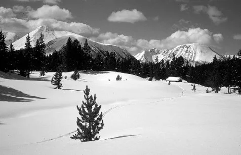
Spanish Camp Basin–Forest Service cabin right center.
We had several miles to travel before reaching the Spanish Camp cabin, but the route was through gentle terrain, with meadows separating spruce and lodgepole pine, so we did not expect any delays in reaching camp. However, the route had unexpected difficulties. The country’s gentle character, as well as the April snow cover, masked some of the more subtle features of the drainage patterns, making it unclear where a minor, yet critical drainage, leads toward the cabin site. Fatigue from a long day had made both of us careless. We inadvertently skied beyond the point where we should have turned away from the main drainage, and found ourselves dropping into a deepening trough. My memory of the area was clear enough for me to know that we had missed a stream confluence. We needed to back-track. We stopped and put on our climbing skins, and began contouring above the creek, looking for the small drainage that surely would lead us to the cabin. Because there was so little daylight remaining, we needed to either find the cabin quickly or choose a suitable campsite on the snow, and begin melting snow for our evening meal. Finally, Rob and I spotted what we were looking for, a slight depression in the snow cover, and began climbing alongside it through dense lodgepole. In less than 100 yards the forest ended. A large, flat meadow extended nearly a mile in the direction of Amphitheater Mountain. The cabin stood in front of us, much closer to the forest edge than I remembered. It felt satisfying to open the door and set my pack on the dry floor, and its wooden bunks looked inviting. In a few minutes Rob and I were drinking hot cups of soup, tired but pleased we had taken the extra time to ski Bald Mountain. I realized I might not have an opportunity to ski through this area again, so I wanted to take careful measure of this remote corner of the Pasayten Wilderness. Our frustration with missing the cabin seemed minor in comparison, a consequence of not attending to the details of route finding.

Spanish Camp cabin–luxurious in comparison to a tent.
We did not awaken at our usual 6:30 a.m. the next morning. I was surprised when I looked at my watch—8:00 a.m.! Sunlight was streaming into the cabin’s east-facing window. The morning was so sharp and intense, that I postponed my breakfast of instant oatmeal, while I skied a hundred yards away from camp for photos—Andrews Peak framed behind the cabin. While returning I noticed an open section of creek in the meadow not far upstream from the cabin. The snow edge was only three or four feet deep. This was less than half the snow still remaining along the Pacific Crest in other parts of the Cascades, but the Spanish Camp country, several thousand feet higher than most passes along the crest, created a genuine feeling of late winter. The Pasayten country does not receive heavy snows, but its elevation and open vistas create a worthy setting for ski touring.
By late morning we left the cabin for a half-day tour toward Amphitheater Mountain and its views of Spanish Camp Basin and surrounding summits: Bald Mountain, Remmel and Andrews Peak. This day was distinctly different from the previous days of our trip. We could literally feel the transition to spring. In a period of a few hours, late winter all but disappeared. The snow surface was becoming spring-like, warmed and consolidated by the sun. Soft, powdery snow, which had remained on trees for days after the last snowfall because of cold temperatures, was now melting and falling off. Skiing back to the cabin became an authentic spring tour—rounded telemark turns on sun-warmed snow and long traverses across snowy, sun-baked clearings. Just short of the cabin, I noticed something odd on the snow surface near a small rise. I skied closer, and realized a hibernating marmot had awakened and dug out of his burrow, piling soil and rock on the snow.
We planned to leave early the next morning and travel over Andrews Pass, skiing along the Andrews Creek trail for 16 miles to the Chewuck River Road. Rob’s car was parked several miles down the road where it had been blocked by snow nearly a week earlier. Shortly after nine that evening I went outside to look at the stars. As expected they were brilliant, and familiar patterns reminded me of all the other times I have done the same thing. It is always engaging to stand in the middle of a mountain range and watch Orion and the Pleides set during an April night.
The next morning we were up early, ready to depart in little more than an hour. I was putting on my skis when I heard the honking sound of Canadian geese overhead. A large “V” was heading northward for another arctic summer. Again, it seemed the arrival of spring was being pressed on us. The two-mile climb to Andrews Pass was an easy ascent of 500 vertical feet. From that point on, the route down the Andrews Creek drainage to the road would be either flat or downhill for 14 miles. The shoulder of Remmel Mountain, windswept and austere, rose several thousand feet above the east side of the valley. It had seemed remote two days earlier from the summit of Bald Mountain, but now we were gliding by it at a fast pace, using gravity to carry us along the well graded, easy to follow Andrews Creek trail. Its wide clearance and even transitions made skiing it an absolute joy. We skied through mile after mile of spruce and lodgepole forest, and by mid-afternoon entered stands of large ponderosa pine and Douglas fir, a sign we had reached lower elevations close to the Chewuck Valley. Before long the snow became patchy, so we removed our skis and hiked the last mile, with the last half-mile completely melted of snow.
The rewards of the trip had been wide ranging. I had known that good weather would bring us extraordinary views of the eastern and central Pasayten Wilderness. What surprised me was the extent of animal tracks, especially bobcat, lynx, snowshoe rabbits, and even moose. To a degree it mirrored the experience Dale Allen and Walt Anderson had over 50 years earlier. Because of wilderness designation, The Pasayten we experienced on skis was much like what Dale saw—a similar sense of remoteness and wildness. It has remained an intact body of land, in many ways free of large-scale human modification.
The Lyman Lake Country
Two of us stood on the summit of Chiwawa Mountain on a cold and crystalline day in early April. The surrounding peaks were white and snow fluted as if we were in the Alaska Range. It had been a substantial snow year, so the white was deep, covering most of the glacial crevasses and rocky outcrops that would be visible by mid-summer. This was the fifth day of a ski tour into the Lyman Lake country and we had been lucky enough to have flawless weather the day of the summit climb. We had left our camp near the outlet of Lyman Lake early in the morning, using climbing skins on our skis for the 3,000-foot ascent. As we approached the lower portion of the Lyman Glacier I realized the wind had stopped. The silence was broken only by the faint rhythmic “beep” of our avalanche rescue beacons.
Very few crevasses were visible on the upper glacier, but as a precaution we used a climbing rope for this portion of the climb. Although most crevasses seemed to be well covered and safely bridged, we chose to keep risk at a minimum. The environment was remote and carried a degree of unpredictability. After caching our skis at the saddle just below the summit, we kicked steps in the wind-packed snow, using our ice axes for balance and support. The steep shoulder of Fortress Mountain was visible to the west, with spectacular snow fluting on its northwest ridge. A massive volume of avalanche debris from earlier storm cycles had accumulated in the upper basin of Miners Creek.
My trip journal describes the summit as “perhaps the most memorable view I have had.” If that statement is no longer true, at least it is close to the truth. Even though our summit stay was short, it was the kind of experience that remains vivid in one’s mind forever. The imagery has not been limited by its initial brevity. We stayed on the summit for about a half-hour, simply staring at what surrounded us, a large portion of a winter-white North Cascades. The time of year seemed to make distances between valleys greater, and the summits taller. Everything appeared to be on a more vast scale. Because of the time of day—it was already mid-afternoon—we reluctantly prepared to leave the summit, first nibbling some nuts, then beginning the short descent to our skis. We quickly reached them, and began a series of fall line descents and traverses, this time un-roped. By now we felt more confident of the snow coverage on the glacier. The north-facing slope below the East Peak of Chiwawa was smooth and covered with remarkably dry, old powder snow. In my journal I rated the experience as “mountain skiing at its best.” There were no other tracks, of course, and the snow was consistent and not difficult to ski, altogether a remarkable setting. The north side of Chiwawa was winter-like against cold, blue skies. In what seemed like a compressed period of time, we arrived at the foot of the glacier and began the long traverse toward Lyman Lake. We simply stood on our skis, sliding effortlessly through the scattered subalpine fir toward camp, relaxed and tired after a wonderful day. Following our evening meal we climbed out of the cabin and watched the alpenglow on Dumbell Mountain, perhaps longer lasting than the previous evening’s display, which had been notable in its length and color. The peak lay east of our camp and had just the right aspect to catch the sun’s last light during early April.

Lyman Lake in April. West shoulder of Chiwawa Mountain.
1966, Ralph Kurtz photo.
Late March or early April in the high Cascades is a unique time of year. At higher elevations there is still the feeling and reality of deep winter, with powder snow on cold north slopes, snow-plastered summit ridges and deep snowpacks. Yet the snow is often more stable and therefore safer for travel compared to early or mid-winter. By mid-March storms are usually less frequent, the snow is often more predictable and avalanches less frequent, unless a warm, rainy period develops, which invariably creates hazardous avalanche conditions. During those times it is best to be elsewhere. Springtime storms tend to be cool, but more likely, yet, are periods of clear weather. The combination of clear, yet cool weather is the ideal, and does occur with some regularity. Equally important, there is the added pleasure of longer periods of daylight.
At mid-elevations, between 4,500 to 5,500 feet, where most campsites tend to be established, the harshness of winter has usually passed by March. Running water can often be found in even moderate sized creeks. This seemingly innocuous fact is significant. The need to go through the tedious process of melting snow for water is eliminated. Our camp at the outlet of Lyman Lake gave us access to a small, open section of Railroad Creek, although some careful snow trail construction was needed to reduce the risk of water soaked boots when filling the cook pot. Seeing open water flow this time of year can stimulate the imagination, reminding one of the return of active life to the high country. A running stream is set against what remains of a long winter—part of the cycle of seasonal change. The experience is intensified by a brilliant April sun.
Our shelter at Lyman Lake was not a nylon tent, but an old snow survey cabin built at the edge of a small opening, about 200 feet below the outlet of the lake. It was constructed in the early 1900s and used for many decades as a base camp for annual snow surveys by an electric utility company. They were interested in knowing what magnitude of stream flows to expect for the upcoming summer. A lean snowpack would mean less power generating potential for the hydroelectric dam at the mouth of Lake Chelan. As was customary, the cabin was left unlocked and available for public use. Ours appeared to be the first entry since the autumn. A solar powered, electronic snow mass sensing station had been installed recently, eliminating the need for people to travel to the site and do live snow measuring. It could all be done remotely, so the cabin was no longer needed for its original purpose. This meant its future was precarious. In the early 1980s the Forest Service determined it had become a problem and a nuisance. The cabin was burned, a victim of managed wilderness and growing recreation use. During the summers campers had been drawn to it irresistibly, creating a wide area of trampled and denuded vegetation.
In April of 1975 this was still a special cabin, offering a cozy base camp for any number of ski adventures. That’s not to say reaching Lyman Lake wasn’t a journey in itself, requiring a long day of travel on skis for friends Steve, Ann and myself, carrying multi-day packs and climbing along a nine mile route. The journey began at Holden Village and ascended the Railroad Creek valley toward Hart Lake, where Bonanza Peak, the highest non-volcanic peak in the Cascades, towered directly above us. A series of enormous avalanche paths flow off Bonanza, emptying most of their debris either beyond the west end of Hart Lake or onto the lake itself. I was impressed at the depth of the debris, fanning out across a large portion of the valley 10-to-12 feet deep. In the Cascades Range, avalanches of this scale usually occur after periods of heavy snowfall, followed by a rapid warmup and rainfall. This day it was clear and cold enough to have frozen the snow hard. Skiing was smooth and easy as we skirted the edge of the piles of snow debris, and we felt at ease, knowing the probability for springtime avalanches was low as long as it remained cold.
Our route ascended the head of the valley, climbing steadily to a point where we could begin a traverse into the hanging valley where we would find Lyman Lake. The view of Dumbell Mountain across the valley was encouraging, indicating we were nearing the elevation of the lake. We made a slight descent without removing our skins, and then a short climb along Railroad Creek for a hundred yards or so. Where I believed the cabin should be was a mound of snow with a decidedly suspicious shape. I was sure there were no large boulders in the area, so I was optimistic we had arrived. Eight to ten feet of snow had disguised it, but after 20 minutes of digging with our small, avalanche rescue shovels, we were able to climb down through our snow tunnel and enter the doorway. We spread down bags across the bunks and settled in. That evening our small cabin had a soft glow from candlelight.
The following morning was clear, although an inch of new snow had fallen while we slept. Our plan was to climb with day packs toward Cloudy Pass and beyond, skiing as many of the basins and faces as we could, enjoying as much of the country as possible. We could only speculate how long the favorable weather might continue. My journal gives a first reaction to that morning: “It’s perfectly clear. We’ll travel to Cloudy Pass and ski.” The experience at the pass brought about long-remembered emotions, with Glacier Peak, Dome, Plummer, Fortress, and more for a 360-degree panorama. Skiing on the north-facing bowls south of the pass was exceptional, but the setting itself created an overall experience that was completely engaging to us. The solitude, the clear skies and the snow flutted summits created feelings that are difficult to duplicate.

Near Cloudy Pass, 1975–a winter of above average snowfall.
In the Lee of Winter Storms: the Enchantment Basin
By mid-morning in late February 1964, four snowshoers began traveling up the Ingalls Creek trail, heading for a campsite where Crystal Creek meets the main drainage of Ingalls Creek, seven miles up valley. This was our base camp from where we would climb the steep Crystal Creek valley and enter the Enchantment Lakes Basin. Lower Ingalls Creek lies in a deep, narrow canyon, which tends to trap cold air during the winter months. Where the trail passed close to the creek we could see how cold weather affects a running stream. Patterns of ice had formed between the stream and the snow cover along the banks, and also atop mid-stream boulders. Some were like stalactites, growing downward from the snow edge toward the water. It was an intricate display of snow and ice, with the white snow turning to deeper shades of blue ice as it neared the water’s edge.
Three miles up valley we noticed where elk had wallowed through the deep snow. Whenever possible, they had taken advantage of easier traveling under the shelter of larger trees, where the snowpack was more shallow. Conserving even the smallest amount of energy was critical to their survival. My friend Don, who was in front breaking trail, spotted a large bull elk a short distance upstream, just across Ingalls Creek in a small opening. He seemed to move with ease, his legs long enough to carry his belly above the snow surface. The snow was sufficiently consolidated a few feet below the surface to support his weight. The big bull seemed unconcerned about our presence, and did not waste energy trying to flee. We did our best to avoid disturbing him by slowly resuming our pace.
The forest opened after snowshoeing another hour, and in front of us was a 50-yard-wide accumulation of avalanche debris, a jumbled mass of frozen snow and conifer limbs. Little imagination was needed to understand what it must have been like as the torrent of snow and debris crashed down the avalanche path, coming to rest at the bottom of Ingalls Creek Valley. The mass of snow had covered part of the creek earlier in the winter, still largely in place after several weeks, except for a tunnel melted by the moving water of the creek.
In the Cascade Range, avalanches of this scale, running the full length of an avalanche path, are often the result of heavy rains on top of a fresh, unconsolidated snowfall. Rain will penetrate to a weak layer some distance below the surface, weakening the snow bonds and adding weight. Eventually a critical point is reached; a massive slab of wet snow is released, dissipating its energy and debris along the way until it comes to rest in the valley bottom. Such large-scale avalanche cycles occur sporadically. Some winters it may happen several times, other years not at all. Their frequency is sufficient to have created, and maintained, the alternating pattern of openings and forest cover, so characteristic of Cascade valleys. In the autumn, avalanche chutes are filled with reds, yellows and oranges, as vine maple, mountain ash and other shrubs are transformed from their summertime green. In most Cascade valleys the bottom portion of avalanche chutes, the run out zones, give unobstructed views of the surrounding peaks. In this case we enjoyed the granite spires of the eastern part of the Stuart Range, rising as much as 5,000 feet above us.
We reached camp just before dark, with barely enough time to set up our tents. Our party immediately grew from four to six. Two of the group had snowshoed up valley the previous day, and had established a comfortable camp. While we were traveling toward camp they had snowshoed most of the way to the top of Crystal Creek, just short of the Enchantment Basin. [4] Their reconnaissance had been fruitful, and reported good news for the rest of us, finding the route to be mostly well consolidated snow, firm enough to climb much of the way without snowshoes. They had carried their snowshoes through most of the steepest terrain until nearly halfway to the basin. A thaw, followed by a period of cold weather, had created a firm crust. Clear nights had compounded the cooling process. The following morning we likewise made rapid progress, using the steps kicked in the snow the previous day.
By late morning a storm front began to cover the Stuart Range, dusting us with snow showers as we climbed higher toward the Enchantments. Just before noon we entered the cirque-like basin below Crystal Lake, although by now the crust had all but disappeared. Shortly before we had strapped on our snowshoes, after we began breaking through the crust into softer snow. At this point we were above the elevation where the previous week’s alternating warm and cold cycle had created the strong crust. It had remained cool enough at the highest elevations for the snow to stay relatively dry, with little melting, even though the overall snowpack was well enough consolidated for enjoyable snowshoeing.
The snow fell harder as we crossed the frozen surface of one of the middle Enchantment Lakes, [5] and became so intense I stopped to pull on my shell anorak. Just before climbing the last few hundred vertical feet to Prusik Pass, I glanced to the west and could see the summit of Little Annapurna, with blue sky surrounding it. The storm front had weakened for a short time, with its edge retreating to the west barely enough to give us 45 minutes of broken clouds. We were far enough east of the Cascade Crest so that small changes in the intensity of the storm could give us periodic clearing, followed by short duration snow showers. The Enchantment Basin, lying at the eastern extremity of the Stuart Range, is often in the lee of southwesterly storms. [6] High summits to the west absorb the majority of a storm’s intensity, leaving the Enchantments with less snowfall, and consequently more sunshine.
It became bright enough that I stopped and reached into my pack for my sunglasses and camera. The basin was blanketed with several inches of fresh snow, and the sunlight was intense against the snow and blue sky. In less than an hour, and just as we reached Prusik Pass, the snow showers returned. Even so, we could clearly see the Rat Lakes basin and Cannon Mountain. The vertical granite of Prusik Peak seemed much colder with the darkening sky.
The descent to camp was relaxing, snowshoeing easily across the upper slopes, and finally plunge stepping with climbing boots the last few thousand feet. The next day remained overcast as we departed camp and snowshoed the seven and one-half miles to the trailhead. The weather had been less than ideal, but we had been fortunate. The general overcast had been broken by a short period of brilliant sunlight and blue sky. It had happened at the right time, when we could stare at the summits above frozen, snow-covered lakes.
Traversing a Snow Engulfed Entiat and Chelan Mountains—April 1999
From the late 1970s through the early 1990s, the Cascade snowpack, more often than not, was below the average of the previous 30 years. None of the winters equaled the record year of 1955-56, or even approached winters of the late 1960s or early ‘70s. [7] Even so, snowfall had been sufficient during the “lean decades” to provide good ski touring in the high country in even the driest winter on record, the drought year of 1976-77. During that remarkable winter, December and January were mostly clear and dry, with at most a few feet of snow at the highest elevations along the Cascade Crest. The Eastern Slope was little more than dusted by snow. In mid-February I hiked through less than a foot of fluffy snow on my way to the summit of Wedge Mountain, where I looked down on nearly snow-free, but solidly frozen over Snow Lakes. Beyond Snow Lakes and over a thousand feet higher, the Enchantment Lakes appeared colder yet, with very little snow—austerely windswept and gray. By late February of that year strong storms began to arrive, with snowfall continuing through March and into April. But even with the late storms, the highest areas near the crest accumulated little more than half their usual depth of snow, and the Eastern Slope even less.
The winter of 1996-97 was the initial break from the pattern of the late ‘70s, ‘80s and early ‘90s. Snow depths returned to the Cascades reminiscent of the early 1970s. By March the snow stake at Stevens Pass indicated over 180 inches of snow, reminding old-timers at the ski resort and at the Department of Transportation of their younger days, when they were driven by the excitement and hard labor of intense, prolonged storms. The following season was modest, but the winter of 1998-99 engulfed the Cascades with the deepest snowpack in over 40 years.
By March of 1999 the snowpack was second only to that of 1956, filling the highest basins with an overwhelming burden of white. Oversized cornices from windblown snow overhung nearly every ridgeline. In late March my wife Ann and I skied along the summit of McCue Ridge in the Chiwaukum Mountains, and experienced first hand what I had expected to see. The high point of the range, rising above the trough of Glacier Creek, was plainly unlike what we had seen on previous tours along the ridge. Both of us were struck by the degree that irregularities in the terrain had disappeared—the landscape appeared to be enveloped. Normally distinct features of rock ribs and gullies, usually visible in mid-winter, had disappeared under a white shroud.
Several weeks later, when my friend Rob and I began a weeklong ski tour across the Entiat and Chelan ranges, we already knew we would be skiing over the deepest Cascade snowpack we had ever experienced. After being transported by snowmobile for several hours up the Chiwawa and Minnow Creek road systems, we shouldered our packs and began climbing on skis. That evening we hoped to reach the high divide between the Chiwawa and Entiat Valleys, named by Sylvester the Entiat Mountains. Our route wound through a protected basin dotted with larch, spruce and fir. The afternoon’s warmth brought out the refreshing, resinous scent of subalpine fir.
By late afternoon we crested a broad ridge leading to the main divide, equidistant between Rampart and Garland Peaks, jutting above most everything else. To the west were rows of increasingly distant peaks: Clark Mountain, Buck, Indian Head, Chiwawa and Fortress were smoothed with deep snows, their lines much softer than I had ever seen. Whitebark pine dotted sections of the ridgeline, back-lighted by the late afternoon sun. By six o’clock we reached an inviting, solitary grove of whitebark on the shoulder of Rampart Mountain. Surprisingly, it was windless. Camping exactly on the backbone of the high divide, Rob and I could look alternately into the Entiat or Chiwawa Valleys. That night the skies remained clear without exception. The Milky Way was full of detail; Jupiter was a brilliant point of light framed by the summits of Rampart and distant ranges.

Chelan Mountains from shoulder of Rampart Peak,
Entiat Mountains.
The clear skies had created a rock-hard crust on the snow by morning, so little effort was needed to traverse across the gentle slopes beyond camp. That same crust created some anxiety as we skied around the south side of Rampart Mountain, and began crossing some very steep slopes. At one point we removed our skis, and with considerable care, kicked steps down the most severe pitches. After descending a few hundred feet we reached a basin where we again used our skis, climbing in the warming sun to the high saddle between Rampart and Fifth of July Mountain.
Once at the saddle the impact of this unusual winter again became clear. Cornice development along the ridgelines was massive and continuous, as if oversized mushrooms of snow had grown at every conceivable location. Snow was plastered along all the north faces, making an April day appear as white as mid-winter. The cool spring had helped to prolong the feeling of winter.
The ski descent from Fifth of July Pass toward the Entiat River was a drop of over 3,000 feet. After some careful searching, Rob spotted a narrow gap in the cornice line along the arc of the pass, giving us a steep but direct line to the slopes of the upper basin, the next step in our route toward Cow Creek Meadows. By skiing back and forth across the crowns of several prominent ribs—avoiding the more exposed portions of the cirque—we reduced the danger from any avalanching snow that might be channeled into the expanding gully and alluvial system. Reaching the meadow gave us a sense of relief, with the most difficult passage of the trip behind us. I removed my pack and looked at the snow fluted rock faces above us, finally able to thoroughly enjoy the alpine setting. Skiing from Fifth of July Pass had created some anxiety for me, but it was also an experience of intense beauty. We timed our crossing of the pass so that the late morning sun, which could warm and de-stabilize the snow, had not yet struck the snow-filled chutes above our descent line. In few other cases is timing so crucial.
Even with the massive snowpack, we spotted one short section of open water on the outlet stream flowing through the meadows. The snow walls bracketing the creek were in excess of eight feet, unusual for so far east of the Cascade Crest. Most winters Cow Creek Meadows would be lucky to see a snow depth of five feet. As we skied beyond the meadows into the old growth forest, I soon gave up hope of following the route of the summer-time trail. All the signs I would normally look for—cut limbs and the contour of the trail telegraphed through the snow—were invisible. The snow was too deep, masking everything but the most gross features.
By mid-afternoon we skied to the edge of the Entiat River where the summer trail crosses the river on a sturdily built bridge. It was now covered with a snow load several feet above its railings. I skied across quickly, questioning for a moment whether my added weight might be the last incremental mass needed to overload its structure. Rob crossed just as quickly, and we were on our way up-valley for a few miles before choosing a campsite. We settled for a pleasant spot a short distance from the river’s edge, protected by several large Douglas fir and a solitary white pine. After walking down a short snow bank to the river, I was impressed again by how unusual this winter had been. Although there was open water in several locations, three quarters of the river was covered with a substantial amount of snow. For a river of this size in April, the lack of open water was surprising.

Cow Creek Meadows–looking at Fifth of July Pass
and descent route.
The following day we skied up-valley on a long day tour into the expansive Entiat Meadows. Although the deep snow camouflaged the contour of the trail across the valley floor, its general route was easier to follow than I expected. Relic, white insulators from a long abandoned Forest Service phone line had been nailed high on the trees, but now they were near enough to our line of sight to be easily seen. Since phone lines had usually followed trails, the insulators were like beacons. In most years they would have been difficult to recognize, lost above us in the maze of limbs and boughs.
As we traveled up-valley the river became increasingly blanketed by white. Several miles above the confluence with Snow Brushy Creek, we began using the river channel as our winter trail. It was flat, uniform and easy to ski, with only occasional areas of open water, all easily avoided. Traveling like this is rare in the Cascades, although common in colder climates, like interior Alaska, where the deep cold makes it possible, freezing their rivers into reliable winter routes of ice. In our case, massive snowfall had created a white trail.
That evening the gentle, muffled sound of running water reminded me that we were on an April ski tour, with the best of both winter and spring. After an early breakfast the next morning, we skied up valley several miles, and then turned northward, following the Snow Brushy Creek drainage toward Milham Pass. We neared the summit by mid-afternoon as a two-hour snow shower passed overhead, the overcast masking most of Saska Peak as we skied below its brooding, darkened base. The pass itself is unusually abrupt, and although rimmed by trees, is cliff-bound except for its western end. At this point a series of larch covered benches give a safe ski route into the Lake Chelan watershed. We needed only an hour to descend into Emerald Park, skiing from bench to bench among stands of larch and Engelmann spruce. This is the same route A.L Cool snowshoed for many winters in the late 19th and early 20th centuries, while working his trap lines (see Chapter 7).
Skiing across the expanse of Emerald Park was nearly effortless, its gentle upper section blending into the main meadow at a grade ideal for gliding on skis. We camped on the northwest edge of the park, a place Cool had used for decades as one of his fall hunting camps. Thickly boughed subalpine fir and spruce would have given us protection from an evening storm, but clearing skies by 4 p.m. made that unnecessary. Still, the trees gave the camp a sense of security as a place to rest.

West shoulder of Emerald Peak and the expanse of Emerald Park.
Rising steeply at the far end of the park, Emerald Peak was high-lighted by the afternoon setting sun, its rock faces bright and sharply defined from a fresh cover of April snow. Emerald Park proper was flat, in appearance nearly identical to a frozen lake. With the amount of snow present, there was no chance of finding open, running water from any of the tributaries of the main creek. From summertime trips, I remembered the creeks in this part of the meadow being rather small, not forming a large, singular flow until the lower end of the valley. Because of that, I did not bother to dig snow in a search for water; it was a better use of my energy to simply melt snow. The evening was filled with wonderful sounds—a gentle breeze passed across fir and spruce boughs, a quintessential sound of the high country.
Before leaving Emerald Park the next morning, we climbed a few hundred vertical feet up the slope adjacent to camp—part of the dividing ridge that towers between Emerald Park and Mirror Lake—and made an early morning ski run. The snow surface was firm because of the cold, clear night, but it skied as smoothly as a groomed slope. Both Rob and I were inclined to delay our departure. Neither of us was in a rush to leave such a place.
Gliding down Emerald Park Valley later in the morning was supreme mountain skiing, with a layer of sun-softened corn snow, and high, snow fluted ridges framing both sides of the valley. In only a few hours of rapid descent we were at the edge of Domke Lake, where a melted-out trail led a mile and one-half to Lucerne and the shore of Lake Chelan. We had experienced in one day a full April transition in the Eastern Slope of the North Cascades. It had begun in the morning next to the wintry summits surrounding Emerald Park, and ended by mid-afternoon alongside black cottonwood trees beginning to bud out, soon to be shading grass and shrubs along the shore of Lake Chelan. Before long pine grass would be showing green, and maple and red-osier dogwood leaves were already forming. I emptied my pack and spread most of my gear on the dry grass to freshen. The afternoon sun and the expanse of Lake Chelan put me in an utterly relaxed mood. I had completed one of the most rewarding ski tours in three decades of ski travel.
Chapter Thirteen
Seasonal Change
In late June or early July the high country of the Cascade Eastern Slope undergoes a metamorphosis, the annual springtime rush of plant growth. The timing varies slightly from year to year. Several factors—the depth of the winter snowpack, springtime temperatures—all combine with a location’s elevation and aspect to the sun, in determining when the surge of plant growth is most intense.
Regardless of a year’s precise timing, the winter snowpack eventually becomes patchy and the first glacier lilies push through the remaining inch or so of softening snow. Walking through a basin during this time of transition is both engrossing and evocative—seeing the rapid snowmelt and the response of plant life to increased warming and sunlight. How the first pulse of plant growth can respond to what must be small increases in warmth, is not easy to understand on an intuitive level. But the process occurs nevertheless. Glacier lilies begin their growth cycle before the snow has completely melted from the ground. Hiking across a basin still partly covered with snow, it is apparent the small, yellow flowers have received enough warmth to begin their period of growth while covered by a thin layer of snow. They push through the snow with green leaves and developing flower heads, surrounded by a shallow cover of old, melting granular snow. By the time a field of glacier lilies is in full bloom, the snow is mostly gone, receding to the edge of a mass of yellow and green.
Boulder Basin, east of Clark Mountain in the Tenpeak Range, has a blend of topography, aspect and moisture, ideal for spectacular blooms of lilies. In the early summer Boulder Basin will be in a full bloom of yellow, while above it Clark’s East Peak is still surrounded by a substantial snowpack. By the time the lilies in the lower portion of the basin are beginning to fade, pink heather is blooming on drier, more sun-exposed locations not far away. Enough additional warming has taken place for them to progress along their annual cycle.
A late June climb of Clark in the early 1960s gave me my first long, close look at springtime in Boulder Basin. A mile before entering the basin proper, the trail climbs through a series of meadow slopes, divided by sections of alder brush, mountain ash and small streams. The meadows were a soft, yet vibrant yellow, a dense covering of glacier lilies thriving beneath the East Peak of Clark Mountain. We set camp at the edge of this display, no less stunning than the rocky summit above it. The same springtime transformation takes place in countless places along the Cascade Eastern Slope, but none has been held as clearly in my memory as this place.
During this period of change—warming temperatures and rapid melting— water is everywhere, flowing through every conceivable channel as it descends toward the larger streams feeding Boulder Creek. Dozens of waterfalls and cascades pour from the permanent snowfields of Clark’s East Peak, creating the muffled background roar so distinctive of high cirques in the Cascades. The sound will last in diminished form throughout the summer and fall, until silenced sometime in late November, with the arrival of early winter’s new snow. The main channel of Boulder Creek, while easy to cross on exposed rocks in early autumn, is a serious obstacle in June, sometimes requiring a handline or rope belay for safe crossing. By late July springtime is usually over, and high summer overtakes the basin, covering the meadows with a combination of late blooming and matured plants. Grasses and sedges are a rich green, undulating in afternoon breezes. Seasonal streams no longer flow, only year-long streams remain, fed by springs and permanent snowfields.

Glacier Lily

Anemone
The springtime rhythm of western anemone is another measure of the remarkable time of snowmelt in the Cascades. Their flower heads are visible soon after the snow recedes, beginning to grow and flower, even while nearby grasses and sedges are still gray and compacted from the effects of winter’s snow. By the time grasses are showing green from new growth, anemone have already developed their tall, soft seed heads. Their phase of early and rapid growth is over, even before the new growth of many other plants is noticed.
At about the time the subalpine meadows are a blend of snow patches and bloom from the earliest flowers—anemonies and glacier lilies—the bare, sun exposed south slopes of the highest ridges are reaching maximum bloom. Because they are exposed to winter winds that continually erode the snowpack, and are warmed by the springtime sun melting what little snow remains, windward, south-facing slopes begin their bloom cycle before more protected, lower elevation areas are even snow free. The summit plateau of Big Jim Mountain along the top of Icicle Ridge, exposed to wind and sun, is a mosaic of granite outcrops, small boulders and slowly decomposing granite-based soil. By early or mid June this rocky habitat is dotted with Cascade dryas, phlox, dwarf lupine and buttercup. The plateau’s full bloom is weeks ahead of Cabin Creek Basin, a thousand feet below. Cabin Creek’s anemone and shooting stars are only beginning to bloom, with shaded portions of the basin still deep in snow. Trying to hike the trail system this time of year can be frustrating, alternating between short sections of dry trail, patches of soft snow, and muddy, stream-filled sections of trail. Choosing a sun-exposed off-trail route is often easier, even if less direct.
Months before the high country loses its snow cover, the open forest stands of the Eastern Slope’s mid and lower elevations pass through their own springtime transformation. The bloom may be less brilliant in comparison with subalpine areas, but this part of the Cascade environment has its own strong appeal. It is at its best when set against the snow-covered high country of April, when one can descend from a ski tour into a sunny, snow-free forest.
In late April our party of four ski tourers were ending a fiveday traverse of the northern half of the Sawtooth Range. Each day had been clear and sunny, giving us firm, frozen snow for fast traveling in the early morning, changing to a sun-softened surface by mid-day. The snow was five or six feet deep in most areas, making ski travel efficient over a nearly continuous snow cover. We skied across frozen Lake Juanita, its April snow and ice cover easily holding our weight. This small lake is near the upper end of the Purple Creek Trail, which descends 6,000 vertical feet to the community of Stehekin at the head of Lake Chelan. Our ski descent began at the edge of a steep basin, quickly reaching a thickly forested area, where we began looking for any indications of the route of the summer trail. Finding it would make our descent much easier through the dense forest of the upper few thousand feet. Luckily we spotted a narrow swath through the trees, the most obvious indication of a trail this time of year, and traversed along the snow-covered path, side-slipping the skis to control our descent, and kick-turning when we reached a trail switchback. Eventually the snow became so patchy that ski travel was no longer practical. With mixed emotions we strapped skis onto our packs. Walking on the damp, soft soil felt relaxing to our knees, now freed of the stress of turning and controlling skis on the afternoon’s melting, heavy, water saturated snow, but we missed the speed and fluidity of a ski descent.
After dropping another 1,500 vertical feet toward Lake Chelan, we entered an elevation zone where willow and alder, growing in small gullies and more moist areas, were beginning to leaf. Seeing and smelling this change became a surprisingly important event for us. Because the previous four days had been spent camping and traveling on continuous snow, we were especially receptive to changes brought by the warmth of springtime. The rapid transition of our descent, exaggerated by being on a south-facing slope, created a setting where we experienced nearly constant change. Our senses were absorbing everything new. The smells of the vegetation, the different shades of green—all helped define the Stehekin country in late April.
Lake Chelan was still several thousand feet below us, a mellow blue against the fresh green of new leaves. As we continued dropping toward the lakeshore, the effects of spring became stronger. Balsam-root and service berry were blooming, adding smells from their yellow and white flowers. As we neared the lake edge we began to feel the afternoon warmth, reminding us that summer in the Cascade lowlands was only a few weeks away. By late June, the high country of the Sawtooth Range would be going through its own springtime transition.
Near the middle of May the lakeshore near Stehekin reaches its peak of spring color, as scattered Pacific dogwood trees become covered with large, creamy white blossoms. The Chelan Lakeshore trail extends along the upper-east side of the lake from Prince Creek to Stehekin, a distance of roughly 17 miles. A shorter version begins at Moore Point near the halfway mark, and includes the majority of the dogwood visible along the route. Hiking begins after being dropped off by the Lady of the Lake passenger boat, whether hiking the entire route or only the upper end. The seven-mile hike beginning at Moore Point is a gentle one, especially in comparison to physically demanding, multi-day ski tours along the Sawtooth Range, 7,000 feet above the lake. But one should not assume that solely because something appears easy, it must be of less value. In this case, my wife and eight-year-old daughter hiked, examined and explored the seven miles of trail, and we were fascinated with what was there.
We did not see dogwood immediately after leaving Moore point, but we did notice a pleasant scent from the decaying needles of the pine forest. Their refreshing smell flashed back to scores of trips begun in the same kind of setting. I spotted the first dogwood as we climbed toward Hunt’s Bluff, and after hiking a hundred yards, we noticed they were growing on both sides of the trail. Their blossoms were larger than I remembered from earlier trips in the upper valley, approaching six inches in diameter. While common in many valleys west of the Cascade divide, Pacific dogwood is rarely seen east of the crest, with the notable exception of the Stehekin area. The lake’s moderating influence on wintertime minimum temperatures may be a factor.
At our slow pace we were able to see things more closely, passing few plants or physical features unnoticed. The trail alternated between moist, shaded ravines and drier, sunny hillsides broken by granite bluffs. Even some of the sunnier hillsides had moist seeps, where we spotted mosses, small yellow monkey flower, ferns, death camas and alum root. Drier areas were filled with lupine in full bloom, kinnikinnick, prairie star and wild onion. Soft, bright green pine grass covered the shaded areas under the pines and firs. Douglas fir were beginning to push out new growth from their end buds.
The weather had recently turned warm, so snowmelt was pushing the stream volumes to high levels, creating a genuine sense of adventure for an eight-year-old crossing some of the streams that were absent footlogs. Our evening’s camp at the Flick Creek shelter was opposite a series of falls tumbling off Castle Ridge a half-mile across Lake Chelan. At that distance, the sound of water rushing over falls and cascades created a muffled vacillating sound—a rhythm and fluctuation presumably caused by changing frequencies of sound, perhaps related to air turbulence and density changes. Whether my explanation is correct or not, I do not know, although the phenomenon is common throughout the mountains, in this case along Lake Chelan, while camping and hiking in a forest of dogwood and pine.
After an especially enjoyable April ski tour in the Lyman Lake country, I was mentally tuned for more spring skiing in May. Early May can offer exceptional skiing, with firm corn snow at the highest elevations. But while I was initially drawn toward skiing, circumstances moved me in another direction. My wife suggested an alternative away from the snow, experiencing springtime in the Wenatchee Mountains, the rugged hills to the east of the Cascades—in this case the Mission Creek drainage.
Mission Creek and Devil’s Gulch are bisected by a well-defined ridge-top, extending from the confluence of the two creeks toward the summit line of Mission Ridge. A Forest Service trail extends its full length, eventually connecting to the upper reaches of the Devil’s Gulch trail, a more frequently traveled paralleling route. Both trails are free of snow early in the spring, and by May the pine grass has become a soft, shimmering green. Balsam-root were blooming along the first few miles of trail, although the expanses of bright yellow on the hillside across Mission Creek were slightly past their best color. Even so, we noticed clumps along more shaded sections of trail that were at full bloom. As we climbed higher we began walking through patches of lupine, although their flower heads were only beginning to push above the main plant body. In another week or 10 days they would be near full bloom, but even now there was a suggestion of the intense blue to come. Their developing flower heads were soft and delicate appearing, yet changing rapidly as the hills moved into mid-May.
We stopped at a clearing short of the junction with the Devil’s Gulch route, but high enough for a full view of the hills blending into mountains. To the west we could see several summits of the Stuart Range rising above the sandstone slopes across Devil’s Gulch, and even though clouds veiled much of the North Cascades, the Entiat Mountains were in sunshine over 40 miles to the north. The sun’s warmth gave our resting spot a full share of comfort. The pleasant temperatures intensified the springtime smells of this ponderosa pine landscape, with its balsamroot, scattered sage and wild onions. Aging needles littered the ground beneath all the pines, giving a penetrating, pleasant scent so distinctive of a mild, springtime day in a pine forest. The odors sparked memories from trips many years earlier—a remembrance due to the immediacy of our sense of smell, so evident during times of transition in the mountains.
Our sense of smell can become dulled from spending too many hours indoors, removed from much of the natural world. But a hike into the early stages of autumn can sharpen our sensitivity to small, yet telling changes in the physical environment. In early September, before the first autumn colors come to the high country, there is a subtle yet defining change to the smell of the forest openings below timberline. This effect is most noticeable in small meadows below the elevation of the subalpine parklands. By this time many of the plants have matured, and the changing vegetation is beginning to decompose, giving off a pleasant, musty, organic scent—a sign that summer is ending. The time of ripening huckleberries and the brilliant yellows and reds of autumn is only a few weeks away.
I first recognized what this scent implied while in the Chiwaukum Mountains, working as a wilderness ranger for the Forest Service. Just before the Labor Day weekend I was hiking up the Frosty Creek trail toward Frosty Pass, entering a small meadow basin less than a mile from the pass. This is the same meadow where Sylvester camped on his first trip to the area, when he named Frosty Creek, Lake Mary and Margaret (Chapter 2). As soon as I passed from the forest cover onto the edge of the meadow, I was struck by the scent, and I realized it marked the end of summer. Memories of the same odor from previous trips came together—the familiar odor now had a more precise meaning. On the high meadows above Frosty Pass, far above Sylvester’s old camp, there was still enough early September sun to give the illusion of summer, but the irrevocable signs of seasonal change had already arrived.
Three weeks later I returned to Frosty Pass for my final trip of the year to the Chiwaukums, making sure the drainage ditches along the trail were cleaned and set for the season. It would be nine months before they could be maintained again, probably no earlier than late June or early July. This trip would be the last opportunity to ready them for the spring melt, when they would be important in reducing erosional damage to the steeper sections of the trail.
By now there were only a few days remaining in September. The high country was in full autumn—late summer had long passed. Taller vegetation in the meadows below the pass had been flattened by heavy frost, and even the grasses and sedges had been affected. At Frosty Pass patches of low bush huckleberry were bright red. Looking north down the Wildhorse Valley I could see patterns of yellow and orange from Cascade azalea and mountain ash leaves, especially striking alongside the green of subalpine fir. Snowgrass Mountain’s upper thousand feet had several inches of fresh snow, unaffected by the late September sun. The sunlight only made the scene more brilliant. That evening the sky remained cloudless, leaving another hard frost by early morning. The grass next to my bivouac sack had been stiffened by a thick coating of frost, and it had been cold enough to create hoar frost crystals where the soil was loose along the edge of the trail. The top layer of soil had been lifted by the expanding crystals formed from the moisture in the ground. A temperature gradient between the warmth in the soil and cold air had created a micro-environment for crystalline growth. Only a few hours of warm sun later that morning would destroy them.
As I left the Lake Mary basin that afternoon, I thought about Sylvester’s first trip here in 1909. The trail system was certainly less defined at that time, although sheep grazing had already helped develop the most logical travel routes, at least to the best grazing areas. Sylvester did have the special pleasure and the sense of adventure that comes from traveling a route where only a few had visited before. Even though I could not authentically experience all of what Sylvester must have felt on his first journey, the fundamental character of the land was still intact. The autumn colors and smells were equally accessible to my senses as his. The summits of the Chiwaukum Range were unchanged, and the meadows as expansive as during his time. Even if decades of sheep grazing and recreation had created some changes, they were not of a scale that could distract me from the experience of autumn in the high Chiwaukums.
The Stehekin country is a striking mountain environment regardless of the season, but during late September and early October, fall color changes create patterns of special subtlety and complexity. Its character changes from valley bottom to summits, and from the lower valley near Stehekin to the tributary creeks in Horseshoe Basin and Cascade Pass. From near Stehekin it is possible to look eastward toward the summits of the Sawtooth Range. Distant groves of larch trees are barely noticeable as they turn golden. They are far enough away to give only a hint of their color. Along the bottomlands of the Stehekin Valley, bright yellow from black cottonwoods overwhelms the usually predominant greens of pine and Douglas fir. A slightly less vibrant yellow comes from Douglas maple, a hardy shrub reaching no more than 15 feet off the forest floor. They are dwarfed by the cottonwood, as tall as many conifers. Vine maple, closely related to the Douglas maple but usually slightly smaller, is the valley’s most colorful shrub, with its mixed pattern of red, orange, yellow and green, sometimes on the same leaf. Avalanche paths descend from steeper, higher terrain, and old burns are scattered randomly along the shoulder above the valley. Both are filled with maples and willows, creating long swaths of mixed color.
My climbing partner Don and I traveled through these changing fall patterns on our way to Cottonwood Camp, the end of the historic Stehekin River wagon road. The hiking from this point was through the most remarkable display of fall maples I have seen in the Cascade Range. The vine maples were intense, even though the day was overcast with occasional light drizzle.
As counter-intuitive as it might seem, overcast conditions appear to intensify the contrast between reds, oranges, yellows and greens. The pattern continued up the valley, alternating between groups of maple and cottonwood along the trail. Orange and yellow avalanche paths marked the flanks of Glory and Trapper Peaks. Camp was quickly set up in lower Horseshoe Basin that night as the last of the day’s showers was passing overhead.
The next morning was clear enough to see the summit of Buckner Mountain, 4,000 feet above us and solidly white. Yesterday’s storm had dropped a substantial covering of snow on the upper few hundred feet of the peak. We scrambled through a gully system leading through cliff bands, separating the lower cirque from the meadows and talus slopes below the summit. Rusting machinery from early day mining in the basin is still visible, aerial cables and other metal machinery slowly melting away in the brush, but we were too focused on our route to the summit to spend much time examining it. A few small, scattered larch grew on the upper slopes, now covered by an inch or so of fresh snow. Their needles were far enough advanced—barely attached to their spurs—so that the weight and friction of the new snow pulled some of the needles off as it melted and fell to the ground.
The summit ridge was covered with nearly two feet of fresh snow. We felt as if we had suddenly traveled ahead to early December. Intermittent sun on the snow created a setting of constantly changing light and shadow. We spent a few minutes on the summit, taking some photos and having a bite of nourishment. As winter-like as the summit seemed, after an hour’s descent we were back in the high meadows, where the sun had already melted much of the snow we had hiked through earlier in the morning. By early afternoon we entered the lower basin, still filled with reds, yellows and oranges of autumn.
The transition from summit to valley had given us the richest gradations and contrasts of colors, textures and lighting we have been fortunate to see.
Epilogue
On the Edge
Although without any major summits, the eastern portion of Icicle Ridge rises nearly 6,000 feet above the community of Leavenworth. The abruptness of the ridge, set against the flatness of the valley bottom, creates a dramatic edge to the Cascade Range, a visual and geologic line between mountain range and gentle land. The ridge’s granitic origins have helped maintain its steep flanks, where wooded slopes alternate with narrow chutes and rock bluffs. A large wildfire swept across much of Icicle Ridge in 1994—and a smaller one in 2001—burning the forest in a spotty and unpredictable pattern, making some aspects of the topography more apparent than before, especially ravines and rock outcrops—in effect adding variety to the landscape. The confluence of the Icicle and Wenatchee Rivers is at the mid-point of the Leavenworth Valley, directly below where the eastern end of Icicle Ridge almost touches the Wenatchee River. Even as recently as Linsley’s time, the area was a summer and fall encampment of the Wenatchi Indians, a place to catch and dry salmon. Not far from this point is the eastern terminus of the present day Icicle Ridge trail, beginning 25 miles to the west at Frosty Pass. The trailhead is sandwiched between year-round residences, little more than a mile from the center of town.
Several years ago, during an especially warm period in late August, I began a long day hike across the eastern portion of the ridge. I had traveled the route many times before—sometimes on foot, just as often on skis or snowshoes—but I had never tired of the area’s special rewards. This time I climbed to the ridge-top by way of the 4th of July trail, a relatively steep but direct approach to the summit, passing through a number of distinctive vegetation zones—beginning with ponderosa pine, balsam root and ceanothus brush, and ending with a parkland of timberline plants at nearly 7000 feet. I began early enough in the morning to avoid the warming sun for most of the climb to the top, where I planned to intersect the ridge trail. Two months earlier when I had hiked this same trail, the first few miles were filled with the fresh scent of blooming ceanothus brush, but now most midelevation plants were mature, long past their bloom time, some already dormant because of the lack of moisture.
After a few hours of hiking I reached the crest of the ridge, now in the full sun of mid-morning. Only a few hundred yards west of the trail junction is “Icicle”, the highest point of the eastern portion of the ridge. Its dark, lichen covered granite once supported a Forest Service fire lookout building, artfully designed and constructed, a gem of the early days of the Forest Service. This exposed, weathered structure had withstood severe storms since its construction in 1929, securely affixed by cables anchored in granite bedrock. Sadly, it was removed in the late 1960s when the technology of wildfire detection changed from fixed visual searches based on lookouts, to the use of small aircraft. Once in the early 1960s I snowshoed to its base, and after spending considerable time removing one of the window shutters, managed to squeeze inside. It gave me wonderful shelter from a cold February wind. The Forest Service security system was not designed to stop a determined winter traveler from gaining shelter, at least not one with a screwdriver on his Swiss army knife. I miss that weathered building, although I can understand the Forest Service’s need for relief from its continuing maintenance demands, especially as the structure aged.
I followed the ridge trail eastward from the summit as it wanders between weathered granite outcrops, groves of whitebark pine and subalpine fir, and sparse meadows. The rolling ridge crest offers an interesting contrast to the serrated skyline of the Stuart Range to the south. While no doubt less dramatic than climbing in the taller range, hiking along the ridge can become engrossing in its details—in ways more engaging because what is there is less obvious. The land is dry by late summer, especially along the backbone of the ridge where the wind and sun have a desiccating effect. But there are areas where gentle meadows (actually very shallow basins) have developed because of moisture retained in the soil. In these areas vegetation is more dense, and in two locations small springs flow throughout the summer, even in the driest years.
The trail nearly disappears along some of the meadows from lack of use. As the years have gone by, grasses and other plants have been healthy enough to reclaim parts of the trail tread. A few small rock cairns placed by the Forest Service help indicate where the trail re-appears at the meadow’s edge. As I walked across the largest of these meadows, I realized once again why this high ridge-top has been so appealing to me. Even though I was only a few miles west of Leavenworth, and on a trail which had been established at least 75 years earlier, the country seemed genuinely wild. Walking along the ridge-top I entered a place where human effects seemed negligible, where I naturally became immersed in the details of the landscape. There were few distractions to lessen the feeling of wildness, even though I was not many miles from where several thousand people lived and worked, including myself. I was easily drawn into noticing less obvious features of the natural world: small plants growing between granite stones beside the trail, and slight differences in bark color between the windward and leeward sides of their trunks and limbs.
At one point I left the trail and walked toward the edge of a large meadow, searching for a spring I remembered from a hike years earlier. I was startled by unexpected sounds that seemed much too close, and quickly realized I had surprised a resting black bear with her cub. She stood on her hind legs and assessed the situation, grunting and watching every act of the intruder. The cub quickly climbed a nearby whitebark pine, while the sow, her black coat lustrous in the mid-day light, continued to guard her cub and their resting spot next to the spring. I moved away as easily as I could, speaking to her in a soft voice, hoping to limit my disturbance of their space. After I had traveled a hundred yards or so, the cub was allowed to climb down from the safety of the pine. I hoped they could continue their day much as before, little troubled by my intrusion. Seeing the sow and cub reinforced my feeling that Icicle Ridge has remained a wildland landscape. The sow bear had felt at home in an open meadow only 50 yards from a trail—a trail used occasionally by people, but not overwhelmed by human use.
Icicle Ridge has remained lightly visited, even though it is bracketed geographically by an all season highway, the community of Leavenworth, and a Forest Service road along the Icicle River. The climb to the top is steep (some might say arduous) but it is less than five miles in length. Even though the overall setting from the ridge-top is dramatic, with the full arc of the Stuart Range only a few miles to the south, and the depths of Tumwater Canyon to the north, the area lacks the one element many people find irresistible. The eastern half of Icicle Ridge has no high lakes. This alone has helped it remain as it is. The high lakes of the nearby Stuart Range have attracted great numbers of people for decades, largely due to the dramatic setting of lake and mountain, of smooth granite against crystalline, clear water. Icicle Ridge, and other areas like it, embody a different kind of wildland setting. Although drama and visual impact are found atop the ridge, much of its beauty is defined in less obvious ways. Trips along its crest have taught me a fundamental principle: in the mountain world not everything of value is spectacular, imposing, or overwhelming. Learning to perceive the less obvious is rewarding, but it sometimes requires us to engage more of our senses, or use them in a different way: the fresh smell of an afternoon shower, the scent of decaying pine needles, or the silver tinge of new growth on subalpine fir limbs.
Places like Icicle Ridge, relatively accessible yet rich as wildland reserves, are scattered throughout portions of the Eastern Slope of the North Cascades. Their value as wildland and wildlife habitat far exceeds their notoriety. Whenever the natural integrity of such areas is retained, whether by enlightened management or accident, natural systems have a better chance of thriving, especially when they are adjacent to large tracks of wilderness. As a consequence, plant and animal habitat are less fragmented. Natural corridors, relatively free of human alteration, allow animals to travel and plants to propagate, so that over time genetic interchange can take place. Healthy, sustainable populations are more likely under these conditions. Allowing nature to flourish does not preclude careful and restrained human use of wildlands. We can be enriched by places like Icicle Ridge, where the opportunity exists for brief but meaningful contact. Recognizing the value of local areas, and protecting them from deterioration caused by drastic human alteration, should be a fundamental strategy of overall wildland preservation. While the preservation of large tracks of wildland should always be seen as an essential goal—whether 500,000-acre parcels in the North Cascades, or 5,000,000-acre reserves in Alaska—the much smaller, nearby areas peripheral to designated wilderness are no less vital. Without question, standing atop the Arctic divide in the Brooks Range and looking across a vastness rarely seen elsewhere on our planet, is a kind of experience one cannot duplicate from a ridge only a few miles from my home. But Icicle Ridge offers other ways of feeling joy and fascination in experiencing the natural world. Even a struggling whitebark pine growing in a rocky outcrop, or a grouse making its mating call, can become starting points in perceiving the complexity and beauty of the natural world.
Previous chapters have described the Eastern Slope of the North Cascades through the journeys of different individuals over a span of 125 years. In some cases a person’s experiences have taken a broad sweep across the landscape and over a considerable period of time. Sylvester may be the best example, visiting a large portion of the range over a period of five decades. In other cases, an individual’s travels have given a more selected view of the Cascades, often a unique, personal glimpse circumscribed by geography, historical setting, or to the extent their thoughts and impressions were written down. Not withstanding such differences, common themes have revolved around the sense of wonder, joy, and the appreciation of beauty, that have so defined being in the wildlands of the Cascades, whether traveling in the late 19th century, the 1930s, or today.
My own years in the Cascade high country have been personally compelling, as might be expected of someone who has been inclined to write about it. While reading and editing the recollections of others, as well as recounting some of my own times in the range, I naturally began to reflect again about the significance of wildlands. As we enter the early part of the 21st century, I could not help but consider why it is remains meaningful, and deeply fulfilling, to experience a sense of wonder and joy about the natural world. The issues have become more pressing as undeveloped lands have grown smaller, while the earth’s human population and its economic and industrial systems have enlarged with such power. Even though wildland reserves exist in national parks and designated wilderness areas, the scale of developed land—that area utilized by the world economy in its many forms, which includes all of us—has grown steadily. Here in the Pacific Northwest, change has occurred at a rapid pace, where the expanding economy and population of the Puget Sound region press hard against the western edge of the Cascade Range. The smaller, but still growing population of Eastern Washington is reaching farther up the wooded valleys and foothills of the Eastern Slope. Homes have been built in areas that, until recently, were largely wildlife habitat or commercial timberland. In earlier decades these areas acted as a buffer between the settled, developed lower valleys and the high elevation Cascades, but now that buffer is diminished. The Cascades stand more in isolation—a region more fragmented.
These underlying changes in the character of the landscape, and the resulting alteration to the region’s ecosystem, are the effects of continuing, deep social and economic shifts that have been taking place in the Pacific Northwest since the middle of the 19th century. In a broader perspective, this transformation is only part of the worldwide growth and dominance of the human-built culture: our communities, industry, technology, transportation, communication and energy systems. The globalization of change and the rapid communication between cultural and economic systems have re-defined our era as a transition into what is sometimes called the “post-modern world”.
The effects of these changes provoke a series of fundamental questions. Has the preservation of wildland, and hence its role as the basis for an elemental human experience of nature, become an anachronism? Has the dominance of the human builtculture— its urbanization, intellectual and artistic achievements, its technological strength, the creation of a human-built world— made a fascination and love for nature a point of view that could just as well be discarded as intellectual baggage of an earlier era, something of only historical interest? Is a love for wildland a passion that only an increasingly irrelevant minority of romantics refuses to relinquish? Or, in what ways can humanity gain perspective, happiness and greater self-understanding from a close tie to a less synthetic world? Might a rejection of the fundamental value of human contact with the natural world become the most absurd act of hubris our species could commit?
Answers to these questions can be disturbingly different, reflecting divergent views as to the nature of the human animal— competing conceptions of what it means to be a member of the species Homo sapiens. Thinking about these issues draws us toward contemporary science, philosophy and ethics. It is part of the centuries-old quest to understand both our biological and cultural heritage, to understand ourselves in the broadest sense. How a person views the nature of the species will determine, in large measure, how one describes humanity’s relationship to everything else in the world. It will determine whether we see ourselves more fully realized in a world where there is genuine natural diversity, as well as authentic intellectual diversity. Our presuppositions will decide whether we see ourselves as part of the natural world, and hence dependent on it for our continued existence, or whether we see humanity as largely autonomous, capable of standing apart from the living heritage of the earth.
Questions about the nature of the human animal are as old as reflective thought itself. Some of the most ancient philosophical thinking expressed keen insights, even though their wisdom was constrained by its lack of a sophisticated science. There is a longlived philosophical and ethical tradition, expressed in classical times by Aristotle in the West, and Confucius in the East, which has viewed the human animal as a combination of multiple aspects, all contributing to the full range of human potential. The Confucian way of thought, perhaps to a greater extent than Aristotle, emphasized a balance between the intellectual, emotional, physical and esthetic aspects of the person, rejecting the myth of a simplistic, singularly defined human personality. If a balance could not be achieved through a process of education, training and life experience, then a distorted human being would likely result, a failure to fully realize our humanity. Although Aristotle gave primary emphasis to the rational or intellectual aspects of the person, he expressed much of the same humanist assumption: what was desirable was a harmonious development of human capacities.
This humanistic concept of the person, undergoing varying interpretations over many centuries, has defined a human being as multi-dimensional, with a suite of emotional and intellectual faculties. The humanist point of departure, extending into contemporary times, has accepted the complexity of human nature as a given, believing that the cultivation of a human being is a multi-faceted, life-long project. This broadly conceived philosophical tradition, while evolving in important ways over time in response to scientific advance, is the very basis for understanding how an engagement with the natural world, and wildlands in particular, enriches our humanity.
In modern and contemporary times the evolution of ideas about the human animal—and specifically the mind— has crossed nearly every possible intellectual boundary. Widely differing schools of thought have waged intellectual warfare during this century-long process: Freud, Jung, behaviorists, the cognitive sciences, advocates of artificial intelligence, philosophers of varying traditions, sociobiologists, and countless others. All have articulated conceptual schemes for understanding the human animal, and often their views have been in apparent conflict. For some the human personality is viewed as harshly fragmented by the contemporary world’s crush of rapid cultural and social change. The very idea of multi-faceted, yet interrelated person has been ridiculed as untenable. On the other hand, others have attempted to synthesize contrasting points of view. [1] This group—influenced by the cognitive sciences—has offered a complex synthesis, the idea of a more flexible and complex human being, responding to life’s different situations with intellectual, emotional and esthetic reactions. While an individual—or the human species as a whole—retains recognizable tendencies regardless of circumstance, human behavior can respond and change as it moves through multiple social, cultural and environmental contexts. This flexibility allows a person to develop most fully, and survive change.
Although separated by 2,500 years, this point of view is surprisingly compatible with the earliest humanist tradition. Their points of similarity reinforce the strength of the core ideas: the human animal is complex, a multi-faceted organism whose full potential requires a range of cultural and physical environments, created through centuries of cultural evolution— differing cultural, intellectual and physical environments providing a rich background for engagement. This brings us full circle to questions raised earlier about the relevance of the world of nature and wildlands, questions about the role the natural world plays in realizing the fullness of our humanity. In many ways those questions have already been answered in the writings of dozens of authors in the present and recent past—from E.O. Wilson and Aldo Leopold to John Muir—and also in the diaries and memories of individuals re-counted in this volume. Wildland experiences are rich esthetically, intellectually, emotionally, physically and even socially. The natural world, especially in a wildland setting, offers an unusually rewarding background for a person to become self-aware, and integrate a wide range of experiences. Human life is enriched by contact with the natural world, bringing wholeness to our experience.
Dale Allen’s comments to me nearly 20 years ago offer a parallel starting point for understanding the human fascination with the natural world—the richness of experiencing wildland, a context for the expression of a multi-faceted personality. Dale was recollecting several of his favorite ski tours. He took these long, sometimes arduous trips “for the simple pleasure of going, just being out in nature...there is the beauty of the country...just being out there...I’m not sure exactly what being in the mountains does to you, but it does something, and it’s wonderful.” Dale’s humility and sense of privacy kept him from saying any more about the personal meaning of his adventures. But what he did say was corroborated by my own feelings, and by the thoughts of many natural history and wilderness writers. A wildland experience is an experience of personal creativity, an esthetic and conceptual engagement with the world-at-large. Only rarely is it a passive reception of sensory images. The experience has depth. One discovers subtlety and complexity in the natural world, and at the same time a sense of inter-relationship between elements of the world at every scale, from the very small to the immense. The smallest colony of lichens is related ecologically and esthetically to the expanse of landscape that surrounds it.
Dale Allen was fascinated with the very act of entering wildlands and spending days engrossed in a wilderness setting. Being there encompassed nearly every aspect of his personality. The character of his journeys demanded a focus of physical and mental abilities, a determination to reach a particular location— a pass, a cabin, some crucial destination. Mental and physical elements were made whole within his personality as he traveled throughout the Cascades. The high country was a setting where the esthetic, emotional, intellectual and physical aspects of his personality could be engaged and stimulated.
I can picture Dale on skis in the 1940s, crossing Ashnola Pass in the Pasayten high country. Despite his physical endurance, Dale is tired as he pauses at the summit, but he feels exhilaration as he crosses the pass and glides north through cold powder snow. He notices the beauty of subalpine fir as he quietly slides by, their boughs softened by several inches of light snow. The wind from the previous day has formed patterns in the snow around many of the tree wells. He hears only a light wind now, but it is an intricate, complex sound. The movement of air through the forest— each tree at a different distance, height and mass—and the muffling of snow, together create a pattern of sound distinctive to the snow-covered high country. Dale’s mind is reaching out with a keen awareness of what surrounds him. His relationship to the natural world is integral to what he is able to perceive. The relationship is not passive, but essentially active. Absent that degree of attention and sensitivity, his journey would have been far less compelling.
Whether it was the time he lived or the uniqueness of his own way of life, Dale Allen never felt driven to justify the value of wildland experiences to the wider culture, at least to the degree some individuals have. But the narratives of his life in the Cascades portray a person with a powerful sense of exuberance about nature, a genuine and intense ability to see and feel so much of what was around him. What he was able to accomplish on wilderness trips gave him the intellectual and physical skills to deal with other aspects of life, as well. Dale Allen understood that without wildland as one of the viable contexts for human experience, a unique family of human possibilities is lost. To that degree the human enterprise would be poorer.
Much has happened in our world since Dale Allen’s 1940s-era ski tours, and even more since the time of Linsley’s crossing of the Cascades. Whatever else one might say about the last 100 or more years, it has been a time of striking contrasts and far reaching changes. Some of the most disruptive and consequential changes have brought a series of growing challenges to the integrity of the natural world, and to the health of the biosphere itself. Through the growth of population and the continued development of an energetic and extremely powerful consumer- based industrial society, the earth is being transformed into an ever more urban and developed state. Undeveloped land and the diversity of animal and plant life are diminished on a daily basis. In one sense, this thrust speaks of the energy, raw intelligence and adaptability of the species. But in this case, such success should cause concern. It should be an occasion to pause, reflect and re-think presuppositions. It should be a guard against hubris, and an opportunity for the species to act in a more restrained, ethical and enlightened way toward the world that has sustained our species for two hundred thousand years.
One of the most ironic themes of the past century has been the chilling contrast between the heights of human achievement on the one hand, and the devastating crises and suffering human populations have experienced. Two terrible world wars and other, smaller, yet savage conflicts, have torn societies apart and brutally altered individual lives. Yet, during the last hundred years, the human mind has also produced cultural achievements of the most profound and creative kind. The 20th century’s intellectual achievements have been astounding, helping the species understand itself and the cosmos as never before: relativity theory, the quantum theory, the discovery of DNA, knowledge of the expanding Universe, the fields of ecology and bio-diversity, new directions in philosophy and cognitive psychology, evolutionary psychology—the list can be expanded to great length. All of this is part of the human-created culture, and as such, provides a world of stimulating and fascinating ideas, feelings and aspirations.
From a core group of ideas emerging from recent science and thought, a new synthesis is pointing toward a deeper understanding of our species’ relationship to the world. In the broadest sense it describes our place in the cosmos. This intellectual achievement is not an isolated theory or concept, but has become a way of thinking that allows a more comprehensive understanding of the nature of things—a new natural philosophy. It is helping to describe how we can see ourselves, our place in the evolution of life, and our relationship to the Universe as a whole. Included in this development are subjects that span a wide range of inquiry: cosmology, physics, artificial intelligence, evolutionary biology, bio-diversity, nearly all the other life sciences, philosophy and psychology. [2] This way of thinking is grounded upon science and reason, but is inspired by intimate contact with nature and an elemental wonder at the beauty and complexity of the world—wonder at the variety of life we see around us and the patterns that define the changing cosmos.
The ideas implicit in this contemporary synthesis can be condensed into a series of related statements: the human species is part of the natural world and has evolved from it; humans are a subset of the natural world; humanity is not apart from nature. We are composed of the same complex molecules that make up simpler life on earth. We differ in degrees of complexity and structure. Atoms and sub-atomic particles that make up our molecules are identical with those found on distant stars and galaxies. The health and future of the species are dependent upon the health of the biosphere. It is folly to exploit, without restraint and balance, the natural world that sustains us: the breathable atmosphere supported by plants, a life-giving soil and supply of water, a suitable climate, diverse forms of life, and a world of beauty. No matter how highly developed and celebrated the human created culture becomes, we are, in the most fundamental sense, dependent upon the world from which we have evolved. There is an essential connection between ourselves and what we see around us. To deny that connection is to deny the reality of our biological and ecological heritage. It ignores what is essential for sustaining our civilization.
Having evolved both culturally and physically, we as a species carry a kinship with our past, reaching from our nearest descendents of the past few centuries, to our Pleistocene ancestors who hunted large mammals across a vast landscape. The Ice Age environment must have been both inspiring and frightening— humans watching the world before them with awe. Simply surviving required an intimate relationship with nature; knowledge of the immediate was validated every day, and, surely, our ancestors were frequently reminded of limitations to their own power. Their affinity to nature was composed of complementary elements: necessity, perhaps occasional fear, and surely a direct and immediate appreciation of natural beauty.
Our cultural setting is very different from our most distant ancestors, but common realities do exist. The threats faced by humans in Pleistocene times were largely from the natural world, met while obtaining food, shelter and other necessities. The challenges we face in the industrialized countries are often inflicted by our own culture, whether by the socially destructive behavior of groups and individuals, unwise public policy, or the unpredictable and unintended consequences of a host of human decisions. As if embracing a philosophy of total boundlessness, modern society has been the agent of an unprecedented growth in population and resource use, posing a threat to the integrity and health of the biosphere, and thereby risking the sustainability of human society. For traditional hunting and gathering societies, as well as today’s culture, a defining characteristic has been how each way of life, singularly, has perceived the natural environment. With us, the challenge is to understand where we find ourselves, and then act with some wisdom. The uniqueness of our case lies in how far our way of life has removed us from immediate contact with the natural world, as if we are not part of that world, but alienated from it.
Re-connecting with the natural world re-connects us with our ancestral past. Doing so acknowledges humanity as a product of a long evolutionary path, in a biological as well as a cultural sense. To not act in this way severs part of the tie to nature—or tries to—but is really an act of self-denial. A more balanced picture of our species implies human fulfillment within the natural and cultural spheres, placing our humanity within a richer context.
Over the next decades we have the opportunity to synthesize complementary experiences and points of view into a re-formulation of the species’ picture of itself and its relationship to the natural world. Arrogance about human autonomy from the world—the hubris in thinking our species is technologically so powerful, that we could exist apart from our roots and the sustenance provided by the earth—in the end diminishes the stature of humanity. It speaks poorly of our intelligence and rationality. A more comprehensive accounting of our predicament will include understanding the significance of the natural world for human life. Even though the human-created culture is a world filled with fascination, excitement and beauty, its relevance to us does not diminish the need to look in another direction, as well. A synthesis of multiple points of view allows one to become absorbed, for example, in the music of Bach, and later turn, in a complementary way, to thoughts and memories of wildland experiences. The two are not conflicting points of departure. Rather, each provides a rich texture for human engagement.
Contact with the natural world brings us closer to understanding our origins and our relationships to other things, closer to knowledge of ourselves and the larger world. The natural world, including wildlands, retains its value as a creative ground for human experience. The images and feelings experienced by Dale Allen while skiing across the Pasayten Wilderness are unique to a wildland setting, and as such are of supreme value in engaging the human mind.
Reference
East of the Divide
Glossary
East of the Divide
Alluvial—in landform descriptions, a fan-like deposition of soil and gravel where a stream slows in velocity as its slope gradient becomes gentle.
Alpine—in describing plants communities, those growing above timberline. Compare with subalpine below. Also, the mountain landscape of steep rock and ice above tree line.
Begschrund—in mountaineering and geology, a large crevasse at an alpine glacier’s upper limit, where the moving part of the glacier breaks away from the remainder of the ice adjoining the rock. It is often a major climbing obstacle.
Cirque—natural amphitheaters carved on the flanks of mountains by the erosive action of alpine glaciers, often with steep, dramatic walls.
Col—a pass or saddle between summits in mountainous terrain.
Cornice—in the mountain world, an overhang of wind-blown snow forming on the lee of ridges during winter storms, often of significant size.
Couloir—a steep chute or gully, often snow filled, on the side of a mountain.
Crampons—metal spiked attachments for the bottom of mountaineering boots, providing traction on hard snow or ice.
Heath-type meadows—any of the low-lying heather plant communities common in the Cascades—pink, white and yellow (see plant list).
Krummholz—the low-lying shrub growth character of some conifers when affected by harsh, windblown conditions along ridges, especially at or near timberline.
Late-successional forest—in forest ecology, the later stages (oldgrowth or climax) in the natural succession of a forest, in contrast to pioneer species. Plant succession is the natural replacement in a forest of one species by another over time.
Lichen—a compound plant (a union of fungi and algae) growing in patches on rocks or trees, usually rough in texture. Colors can be green, gray, yellow, brown or black.
Little Ice Age—a 14th–to 19th century cooling trend that returned substantial ice to alpine areas (also called the period of neo-glaciation). Today’s glaciers on the Cascade’s non-volcanic peaks are remnants of that period of glacial growth. Compare with the glacial maximum of the Pleistocene Ice Age below.
Metamorphic rock—rock changed by natural processes of pressure and temperature over extended periods of time—common in the formation of mountains. Metamorphic rock is often convoluted. Examples are schist and gneiss, in contrast to granite.
Moraine—deposition (usually boulders and soil) by direct glacial action, either laterally, or at the terminus of the ice mass.
Melt-freeze crust—a snow crust often formed in late winter or early spring, by the alternating daytime melting and over-night freezing of the snow surface.
Parkland—characterized by scattered tree clumps in a meadow mosaic— a signature of the subalpine plant zone, in contrast to the alpine (see above).
Pioneer plants—in plant succession, the first stages of vegetation following a major disturbance, such a fi re, glaciation, avalanches, etc. Alpine larch, lodgepole pine and aspen can all be considered pioneer species, depending upon the site history.
Pitons—metal blades driven by mountaineers into rock cracks, offering anchor points for safety on rock faces—also ice pitons for the same purpose on steep ice.
Pleistocene Ice Age—the last glacial maximum of the Pleistocene Epoch was approximately 18,000 years ago in the Cascade Range, when alpine glaciers descended deeply into the lower valleys (termed the Wisconsin advance, the latest of the several major Pleistocene ice advances).
Rime ice—covering of ice deposited on trees or rocks from supercooled water droplets (water vapor, Fog) during cold, stormy periods. The phenomenon adds considerable beauty to high ridges during winter.
Sedge—the most common genus, Carex, has many members—grasslike vegetation with saw-like edges.
Subalpine—the vegetation zone below alpine but above forest zones, characterized by open meadows, tree groves, lush and diverse vegetation— an area of striking beauty. Parkland is widespread throughout the subalpine zone.
Talus—rock fragments at the base of a steep face, usually of varying sizes.
Telemark skiing—a style of heel-free skiing especially suited for traveling across mountain landscapes on extended tours, characterized by graceful turns.
Wildland—a generic term describing a landscape largely unaffected by human activities—or at least not in the recent past—often providing important wildlife habitat, and allowing for natural plant succession.
Wilderness—wildlands that have been designated by Congress as “Wilderness”, with legal protections against development and misuse. Also, wildlands of great scope, such as the “wilderness of the 18th century North Cascade Range”.
Plant List
East of the Divide
Conifers
Alpine larch—Larix lyallii
Subalpine fir—Abies lasiocarpa
Whitebark pine—Pinus albicaulis
Engelmann spruce—Picea engelmannii
Mountain Hemlock—Tsuga mertensiana
Ponderosa pine—Pinus ponderosa
Lodgepole pine—Pinus contorta
Alaska yellow cedar (Alaska-cedar)—Chamaecyparis nootkatensis
Douglas fir—Pseudotsuga menziesii
Pacific silver fir—Abies amabilis
Pacific yew—Taxus brevifolia
Deciduous Trees and Taller Shrubs
Aspen—Populus tremuloides
Bigleaf maple—Acer macrophyllum
Black cottonwood—Populus trichocarpa
Ceanothus (snowbrush)—Ceanothus velutinus
Douglas maple—Acer glabrum
Mountain ash—Sorbus sitchensis
Pacific dogwood—Cornus nuttallii
Service berry—Amelanchier alnifolia
Sitka alder—Alnus sinuata
Vine maple—Acer circinatum
White rhododendron (Cascade azalea)—Rhododendron albiflorum
Low-lying Shrubs
Dwarf huckleberry—Vaccinium deliciosum
Kinnikinnick—Arctostaphylos uva-ursi
Myrtle-box—Pachistima myrsinites
Pink heather—Phyllodoce empetriformis
White heather—Cassiope mertensiana
Yellow heather—Phyllodoce glanduliflora
Herbs and Grasses
Anemone (western anemone)—Anemone occidentalis
Aster—Aster ledophyllus
Balsam-root—Balsamorhiza sagittata
Bistort—Polygonum bistortoides
Bluebells—Mertensia paniculata
Blue gentian (mountain gentian)—Gentiana calycosa
Bunchberry—Cornus canadensis
Buttercup (subalpine buttercup)—Ranunculus eschscholtzii
Cascade dryas—Dryas octopetala
Glacier lily—Erythronium grandiflorum
Green fescue—Festuca viridula
Lupine (broadleaf lupine)—Lupinus latifolius
Alpine (dwarf) lupine—Lupinus lyallii
Paintbrush—Castilleja spp.
Partridge foot—Luetkea pectinata
Phlox—Phlox diff usa
Pinegrass—Calamagrostis rubescens
Pink monkey flower—Mimulus lewisii
Salmonberry–Rubus spectabilis
Sedge—Carex spp.
Shooting star—Dodecatheon spp.
Twinflower—Linnaea borealis
Valerian (Sitka valerian)—Valeriana sitchensis
Endnotes
East of the Divide
Endnotes Prologue
[1] Fred G. Plummer, “Forest Conditions in the Cascade Range of Washington between the Washington and Mt. Rainier Forest Reserves” (Washington D.C. :U.S. Geological Survey, 1902, Government Printing Office, Document #214, Professional Paper No.6). Chapter 1
Endnotes Chapter One
[1] Although both are commonly called heathers, the two species are not of the same genus, so are only remotely related.
[2] USGS Open File 95-413. “Is glacier Peak a Dangerous Volcano?” U.S Department of the Interior, Cascades Volcano Observatory.
[3] Stephen F. Arno, Northwest Trees, (Seattle: The Mountaineers, 1977).
[4] The trail traversing westward below the summit of the ridge system is an old sheep trail now abandoned by the Forest Service. In places the tread remains good, but in other areas fades.
[5] In 1902 nearly 60,000 head of sheep grazed in the Mad River and Upper Entiat River areas. From An Historical Overview of the Wenatchee National Forest, Craig Holstine, editor, (USDA Forest Service, 1994).
Endnotes Chapter Two
[1] E.C. Pielou, After the Ice Ages: the Return of Life to Glaciated North America, (Chicago: Univ. Chicago Press, 1991).
[2] Wenatchee National Forest Historical Files, Wenatchee, WA, “The History of a Pick”, by Reiff French.
[3] Holstine.
[4] WNF Historical Files, Commentary by Harry Majors on Sylvester.
[5] WNF Historical Files, “Place Naming in the Northwest”, Albert H. Sylvester.
[6] Today’s trailhead is four miles farther up the valley at Blackpine Creek. The classic CCC built guard station at Chatter Creek is still used.
[7] See Chapter 3, Sylvester’s climb of Mt. Stuart.
[8] Chapters 3 and 5 describe two of Sylvester’s other trips.
[9] Edson Dow, Adventure in the Northwest, (Wenatchee, WA: Outdoor Publishing, 1964). 10WNF Historical Files, Majors.
Endnotes Chapter Three
[1] Fred Beckey, Cascade Alpine Guide: Columbia River to Stevens Pass, 2nd ed. (Seattle: The Mountaineers, 1996).
[2] Pielou.
[3] I.C. Russell, “A Preliminary Paper on the Geology of the Cascade Mountains of Northern Washington” (Washington D.C.: U.S. Geological Survey, 1900).
[4] Climbing histories are unclear as to the first ascent of Mt. Stuart by nonnative Americans, but it is assumed the first ascent occurred in the latter part of the 19th century.
[5] Wenatchee National Forest Historical Files, Wenatchee, WA.
[6] WNF Historical Files, J.J. Charlton Journal.
[7] Gene Prater narrative, Wenatchee Alpine Roamers, “1957 Annual”, in possession of C. Marler.
[8] Russell used the name “Wenache” Mountains for what today is usually called the Stuart Range. Today’s Wenatchee Mountains cover a broader area.
[9] Russell.
[10] WNF Historical Files, “Place Naming in the Northwest”, Albert. H. Sylvester
[11] Margaret Stark, How Deep the High Journey, unpublished book, published video tape.
[12] Beckey.
Endnotes Chapter Four
[1] Pielou.
[2] The 1950s and ‘60s were relatively strong snow years. By the late ‘70s the trend seemed to reverse. Recent climate studies have substantiated a 20- 30-year cycle, apparent in weather data in the Northwest since 1900, with a warm, dry cycle alternating with a wetter, cooler cycle. The latter tends to bring greater snowpacks to the Cascades.
[3] Although data is limited at present, grizzly may be migrating from Canada, seeking additional habitat. They were methodically eradicated from much of the American West before the middle of the 1900s.
[4] Personal discussion, William A. Long.
[5] Russell.
Endnotes Chapter Five
[1] I have found Engelmann spruce in the Upper Enchantment Basin, at nearly 7,200 feet, all less than two feet tall.
[2] The 505,524-acre Pasayten Wilderness was established by Congress in 1968. The much older Forest Service administrative classification “primitive area” offered less long-term protection to the area, but did acknowledge its special character as wildland.
[3] WNF Historical Files, Sylvester narrative.
[4] George R. Fahnestock, “Fires, Fuels, and Flora as Factors in Wilderness Management: the Pasayten Case”, from Tall Timbers Fire Ecology Conference Annual Proceeding, U.S.D.A. Forest Service.
[5] A massive wildfire in 2003 burned a large portion of the Chewuch drainage, including much of Andrews, Lake, Farewell and Windy Creeks.
Endnotes Chapter Six
[1] Jack Nisbet, Sources of the River,(Seattle: Sasquatch Books, 1994).
[2] Holstine.
[3] See Cascade Climbing Guide: Rainy Pass to Fraser River, by Fred Beckey. Beckey remains skeptical as to Ross’ crossing point, due to the lack of identifiable details in his journal. See also his Range of Glaciers, where he suggests Ross may have crossed Kaiwhat Pass. Beckey’s account of the Ross exploration makes excellent reading.
[4] Holstine.
[5] WNF Historical Files, “Diary of A.B. Rogers.
[6] WNF Historical files, “Place Names North of Stevens Pass”, Albert H. Sylvester.
[7] “A Railroad Survey Across the North Cascades in 1870”, edited by Harry M. Majors, Northwest Discovery: The Journal of Northwest History and Natural History, Volume 2, Number 4, April 1981.
[8] What Linsley knew as Kaiwhat Pass is not named on present day U.S. Forest Service or U.S. Geological Survey maps. As I interpret Linsley’s journal, Kaiwhat is the pass unofficially named “Garden Pass” in Fred Beckey’s Cascade Alpine Guide. I suggest returning to the earlier usage. A slightly higher pass a mile to the south is named Ross Pass on present maps.
[9] Linsley may be referring to discoloration of the trunk or to effects from lichen growth. The basis for his judgment is open to some skepticism. 10Such open pine stands are usually thought to have been maintained by frequent, low intensity ground fire. Whether the majority of fi re in the lower valleys was caused by lightning or Native Americans is open to debate. Regardless of the principal cause of fire, most fire ecologists assume the central role of fire.
Endnotes Chapter Seven
[1] See Sandy Bryant, Mountain Air: the Life of Gordon Stuart—Mountain Man of the North Cascades, (Wenatchee, WA: Webco Publications, 1986) for an interesting sketch of Cool’s life.
[2] Beckey.
[3] Terris Moore, Mt. McKinley: the Pioneer Climbs,(College, AK: Univ. of Alaska Press, 1967) includes an interesting account of the goals of the expedition.
[4] C.E. Rusk, Tales of a Western Mountaineer—a Record of Mountain Experiences of the Pacific Coast, (Boston and New York: Houghton Mifflin and the Riverside Press, 1924).
[5] Rusk, The Chelan Leader, September 14 and 21, 1906, from the Jean Renfro Collection.
[6] Rusk, Tales…
[7] Rusk, The Chelan Leader.
[8] Ibid.
[9] WNF Historical Files, “Place Naming in the Northwest”, Albert H. Sylvester.
[10] Rusk, Tales…
[11] Beckey.
[12] Rusk called this glacier the Chocolate, and had named the glacier to the north for Cool. The names became reversed over time.
[13] Rusk, Tales…
[14] Ibid.
[15] USGS open file 95-413.
[16] Rusk, Tales…
[17] Ibid.
[18] Ibid.
[19] Bryant.
[20] Methow Valley News, October 14, 1904.
Endnotes Chapter Eight
[1] WNF Historical Files, “Diary of Miss Wheeler”.
[2] WNF Historical Files, “Place Names North of Stevens Pass”, Albert H. Sylvester. 2 Ibid.
[3] The Civilian Conservation Corps was involved in hundreds of miles of Forest Service trail construction, bridge and shelter construction.
Endnotes Chapter Nine
[1] Personal communication with Lloyd Berry, grandson of Ed Lindston, and Berry Family Papers, Wenatchee, WA.
[2] Personal communication with Byron Dickinson, Lake Wenatchee, WA., one-time owner of many of the Phelps Creek patented claims—1980s early ‘90s.
[3] WNF Cultural Resource Site Report, #06-17-06-40 H.
[4] Personal communication with Byron Dickinson.
Endnotes Chapter Ten
[1] Singleton Family Collection, in the possession of Burr Singleton Jr., Manson, WA.
[2] Burr Singleton Narrative, Wenatchee Alpine Roamers “1960 Annual”, in possession of C. Marler
[3] Burr was referring to what was then designated the “North Cascades Primitive Area” by the Forest Service. In 1968 it became the Pasayten Wilderness and the North Cascades National Park.
[4] Personal letter from Burr Singleton, in possession of C. Marler.
Endnotes Chapter Eleven
[1] Holstine.
[2] Descriptions are from a series of Forest Service internal reports titled “Wildhorse Sheep and Goat Allotment”. Dates of the documents vary from the early 1950s to the mid-1970s. Each includes a brief history of the allotment starting at the earliest period of grazing. Located at the Lake Wenatchee Ranger Station, Lake Wenatchee, WA.
[3] “Rock Creek Sheep and Goat Allotment”, as above.
Endnotes Chapter Twelve
[1] Narrative written by Dale Allen, in possession of C. Marler, Leavenworth, WA and Pat Allen, Wenatchee, WA.
[2] Personal interview by the author in the early 1980s, in possession of C. Marler.
[3] Notes in possession of C. Marler.
[4] The pair was Bill Prater and Bill Long. Prater made numerous first ascents of Cascade peaks with his brother Gene, and with others. Long, a geologist by profession, authored many papers and articles on Cascade geology and glaciology.
[5] Called either Rune or Perfection Lake, depending upon the choice of conflicting place names.
[6] On occasion storm fronts approach from the south, dropping more snow on the Eastern Slope than areas near the Cascade divide.
[7] Recent climate studies have substantiated a 20-30-year cycle, apparent in weather data in the Northwest since 1900, with a warm, dry cycle alternating with a wetter, cooler cycle. The latter tends to bring greater snowpacks to the Cascades.
Endnotes Epilogue
[1] Included in this diverse group are the cognitive psychologist Steven Pinker and the computer/artificial intelligence proponent Marvin Minsky.
[2] For an interesting analysis of current trends see John Brockman, The Third Culture, (New York: Touchstone, 1995).